Feeds:
Posts
Comments

Archive for March, 2013

Iowa is dignified by the largest egg of all…

Innovations in poultry maps, 1931…

graduated_egg_map

An egg map of the United States, showing at a glance relative egg production of each state, ca. 1931.

Each state is represented by imitation eggs of different sizes.

graduated_egg_map_all

Popular Mechanics, May 1931

Read Full Post »

Several signal officers flying alone or as passengers were able to make usable sketch maps of the country below them, as they flew two or three thousand feet in the air.

airmap

The practicability of making war maps from aeroplanes during aerial scouting expeditions into the enemy’s territory has recently been tested by the signal corps of the United States army and found entirely feasible. Several signal officers flying alone or as passengers were able to make usable sketch maps of the country below them, as they flew two or three thousand feet in the air. Two maps that were made during these tests are reproduced [above].

One of them is the rough sketch map drawn by Lieut. W.C. Sherman while riding as a passenger in an aeroplane with Lieut. Thomas DeWitt Milling on his record flight from Texas City to San Antonio. Tex., on March 28, 1913. It was drawn while they were traveling 56 miles an hour and, by means of the signal corps symbols, gives a clear picture of the country tover which they passed. Railroads, highways, streams. towns, woods. etc., are marked, and the figures on the lefthand margin indicate the aeroplane’s time. The original sketch is 12 ft. long and to scale, 6 1/2 inches equaling 10 minutes, and 1 in. equaling 1.44 mile. The other is a completed map drawn from a sketch of San Diego; Cal., and vicinity made by Lieut. J. D. Park while flying alone on May 3, 1913. a few days before his death in an aeroplane accident on May 9. The coast line and the topography of the country are indicated clearly enough to be of value to an attacking force, and at various points clear fields where airmen might make safe landings are marked out. Although the strip of country included in the map is 5 miles wide and 15 miles long, the entire sketch was made during a 35-minute flight from the aviation field at the south along the line of the railroad. At times the airman reached a height of over 3,000 ft. and from there was able to note the character of the country for 10 miles about.

Popular Mechanics Magazine, Volume 20, Number 4, October 1913.

Read Full Post »

The isotherms nestle together,
The isobars tenderly twine…
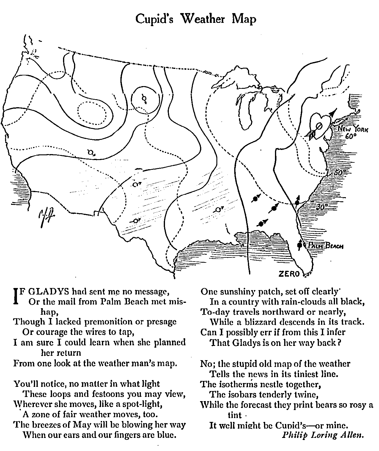
cupids-weather-map-poem-1907_map

Cupid’s Weather Map

If Gladys had sent me no message,
Or the mail from Palm Beach met mishap,
Though I lacked premonition or presage
Or courage the wires to tap,
I am sure I could learn when she planned her return
From one look at the weather man’s map.

You’ll notice, no matter in what light
These loops and festoons you may view,
Wherever she moves, like a spot-light,
A zone of fair weather moves, too.
The breezes of May will be blowing her way
When our cars and our fingers are blue.

One sunshiny patch, set off clearly
In a country with rain-clouds all black,
To-day travels northward or nearly,
While a blizzard descends in its track.
Can I possibly err if from this I infer
That Gladys is on her way back?

No; the stupid old map of the weather
Tells the news in its tiniest line.
The isotherms nestle together,
The isobars tenderly twine,
While the forecast they print bears so rosy a tint
It well might be Cupid’s – or mine.

Philip Loring Allen

cupids-weather-map-poem-1907

Life, February 28, 1907, p. 49

Read Full Post »