
Archive for the ‘10 Type on Maps’ Category
Making Maps now at makingmaps.substack.com
Posted in 01 What's A Map?, 02 Why Are You Making Your Map?, 03 Mappable Data, 04 Map-Making Tools, 05 Geographic Framework, 06 Map Layout, 07 Hierarchies, 08 Generalization & Classification, 09 Map Symbolization, 10 Type on Maps, 11 Color on Maps, 12 Finishing Your Map, tagged Cartography, data analytics, Denis Wood, Geographic Information Systems, geospatial, information design, John Krygier, Making Maps, maps on January 17, 2025| Leave a Comment »
Atlas de Cuba | 1949 | Gerardo Canet & Erwin Raisz
Posted in 06 Map Layout, 07 Hierarchies, 09 Map Symbolization, 10 Type on Maps, 11 Color on Maps, Map Books, Map History, tagged Erwin Raisz - Atlases; Map design - atlases; Cuba - atlases on July 9, 2014| 9 Comments »

This Atlas is more than an attempt to describe Cuba. Our aim is not only to present the setting in which the drama of Cuban life is played but to show how this life itself changes its own setting, creating new problems and new adjustments to them.
This dynamic element is usually absent from the impersonal atlases produced by governments, societies and publishing houses, which merely give a graphic report of a given moment of time. Our objective is to give a living picture of Cuban geography as far as possible in 64 pages. Our approach is as follows: 1. What are the facts?, 2. What are the essential problems?, 3. What will be their effects in the future and what may be done about them? For instance, Cuba, by reason of its close proximity to the United States become its chief source of tropical products, especially sugar. Thus the Cuban economy has become dependent on the fluctuating sugar demand, whereas a diversification of crops and industries would be advisable.
We have presented the results of our labor in graphical form. An old Chinese proverb says: “A picture says more than a thousand words.” Moreover by visual representation the most complicated problems may be brought within the understanding of the layman. Everyone should know the geography of his own country, and in the case of Cuba this need is imperative, since few countries have such clear-cut dependence on location, climate and soil Cuba’s internal problems of adjustment and interdependence with the rest of the world demand a high degree of understanding from its citizens.
– from Introduction
•••••••••••••••••••••••••••••••••
In addition to many dozens of unique landform maps, Erwin Raisz produced three atlases in his lifetime, including the Atlas of Global Geography (Global Press Corp., 1944), the Atlas de Cuba (Harvard University Press, 1949) and the Atlas of Florida (University of Florida Press, 1964). Copies of the Global and Florida atlases are relatively easy to find (used or in libraries); this is not the case with the Cuba atlas, which seems to have had a relatively low print run. A series of maps, diagrams and illustrations from the Cuba atlas are included below.
The Atlas de Cuba strongly reflects Raisz’s aesthetic, combining creative illustration with his bold and cozy aesthetic of map design. Part of the appeal of Raisz’s work is its humane feel, reflecting the manual mapping tools used to create his maps. Raisz’s maps and illustrations clearly reveal the hand of a human creator.
A large format map, included in the back of the Atlas de Cuba, will be the subject of a subsequent post.
See also, at this blog, Raisz’s History of American Cartography Timelines, Map Symbols: Landforms & Terrain, and Raisz’s currently available landform maps at www.raiszmaps.com.
•••••••••••••••••••••••••••••••••

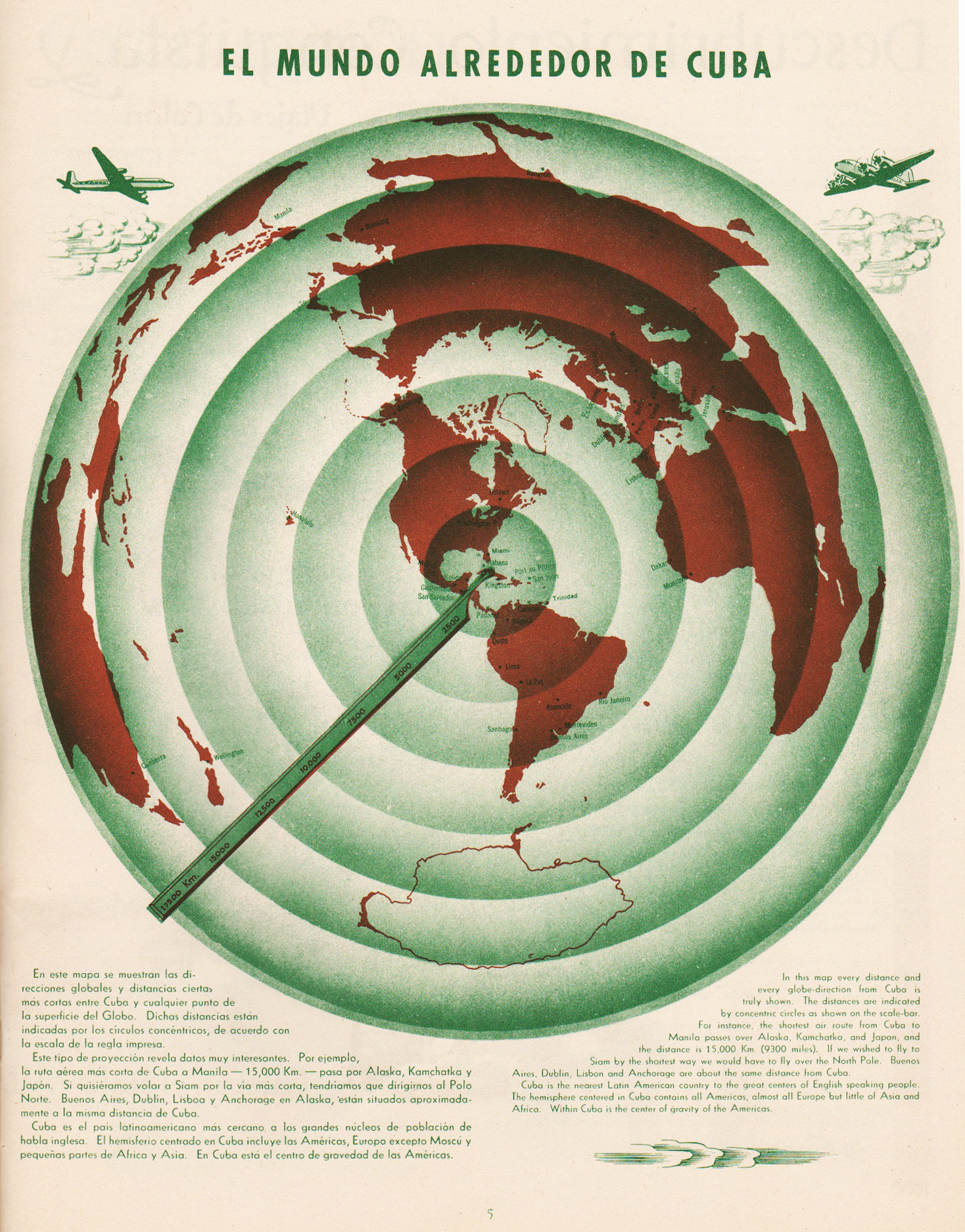
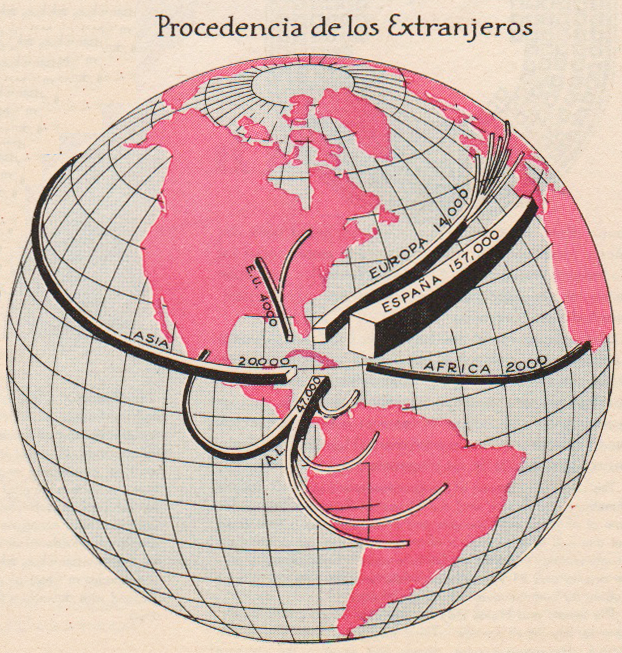
El Mundo Alrededor de Cuba | The World Around Cuba (Excerpt & entire p. 5)
•••••••••••••••••••••••••••••••••
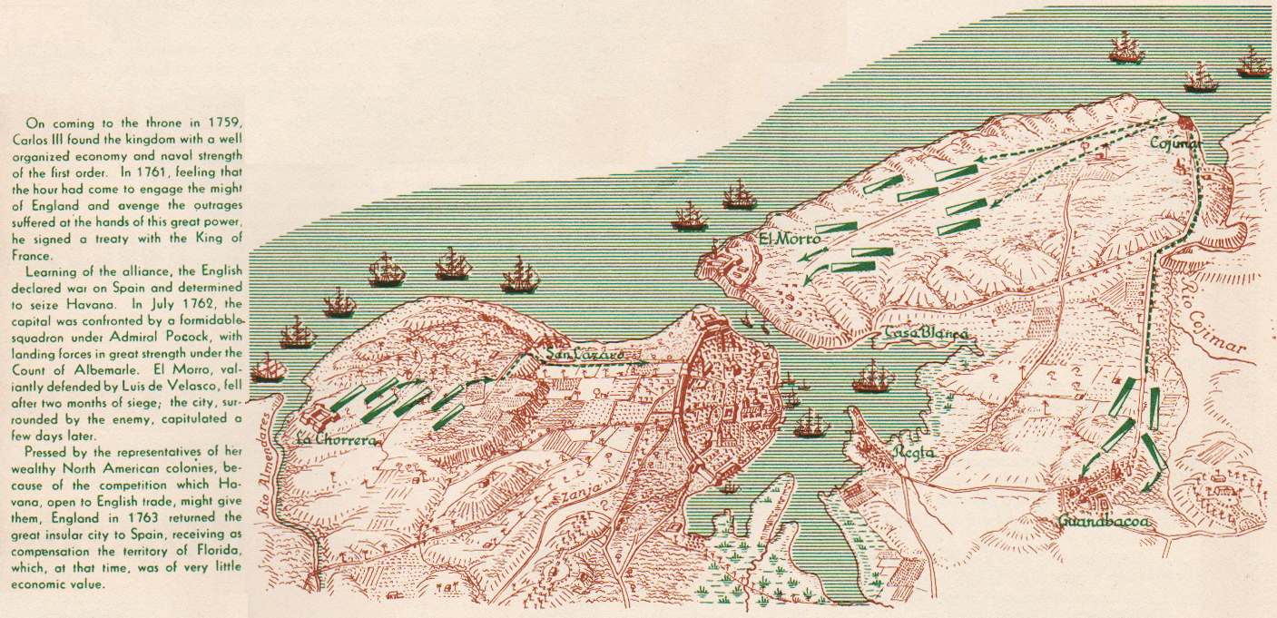
Cuba Colonial | Colonial Cuba (excerpt, p. 9)
•••••••••••••••••••••••••••••••••

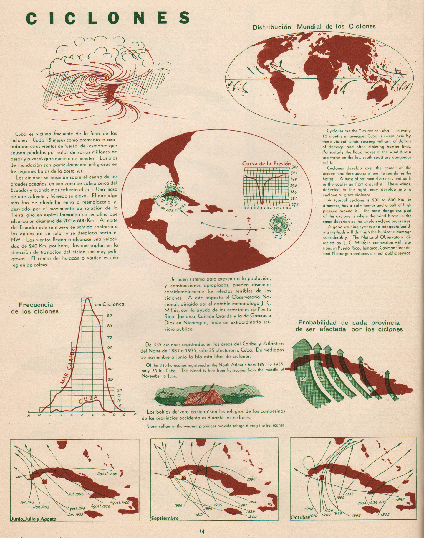
Ciclones | Cyclones (excerpt & entire p. 14)
•••••••••••••••••••••••••••••••••

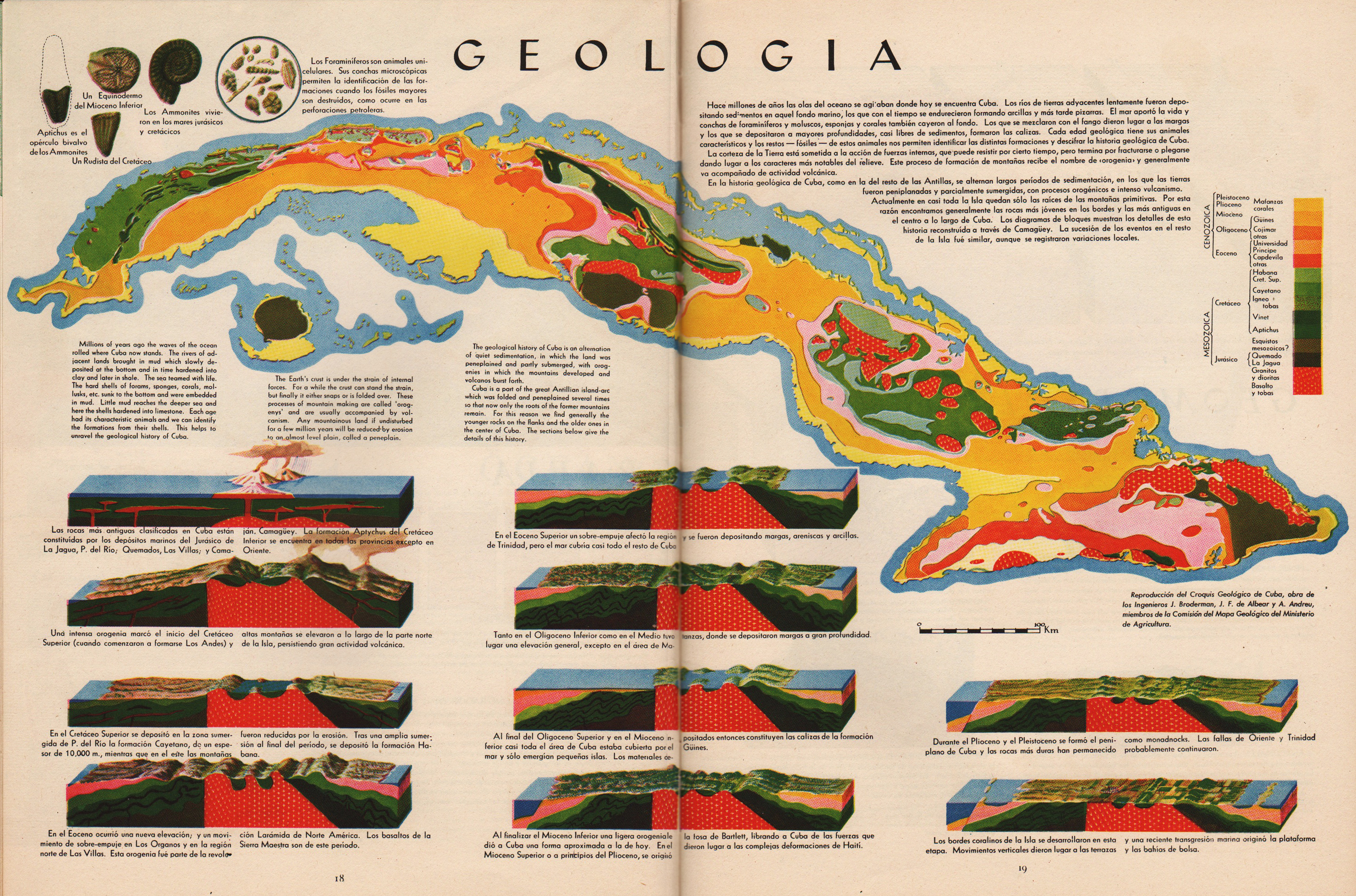
Geologia | Geology (excerpt & entire pp. 18-19)
•••••••••••••••••••••••••••••••••


Geomorfologia | Geomorphology (excerpt & entire pp. 20-21)
•••••••••••••••••••••••••••••••••

Pesca | Fish (excerpt, p. 25)
•••••••••••••••••••••••••••••••••


Vegetacion | Vegetation (excerpt & entire pp. 26-27)
•••••••••••••••••••••••••••••••••

Poblacion | Population (excerpt, p. 29)
•••••••••••••••••••••••••••••••••
Composition Social | Social Composition (excerpt, p. 35)
•••••••••••••••••••••••••••••••••


Tourismo | Tourism (excerpt & entire pp. 38-39)
•••••••••••••••••••••••••••••••••
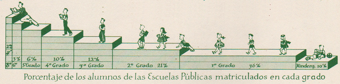
Educacion | Education (excerpt, p. 40)
•••••••••••••••••••••••••••••••••


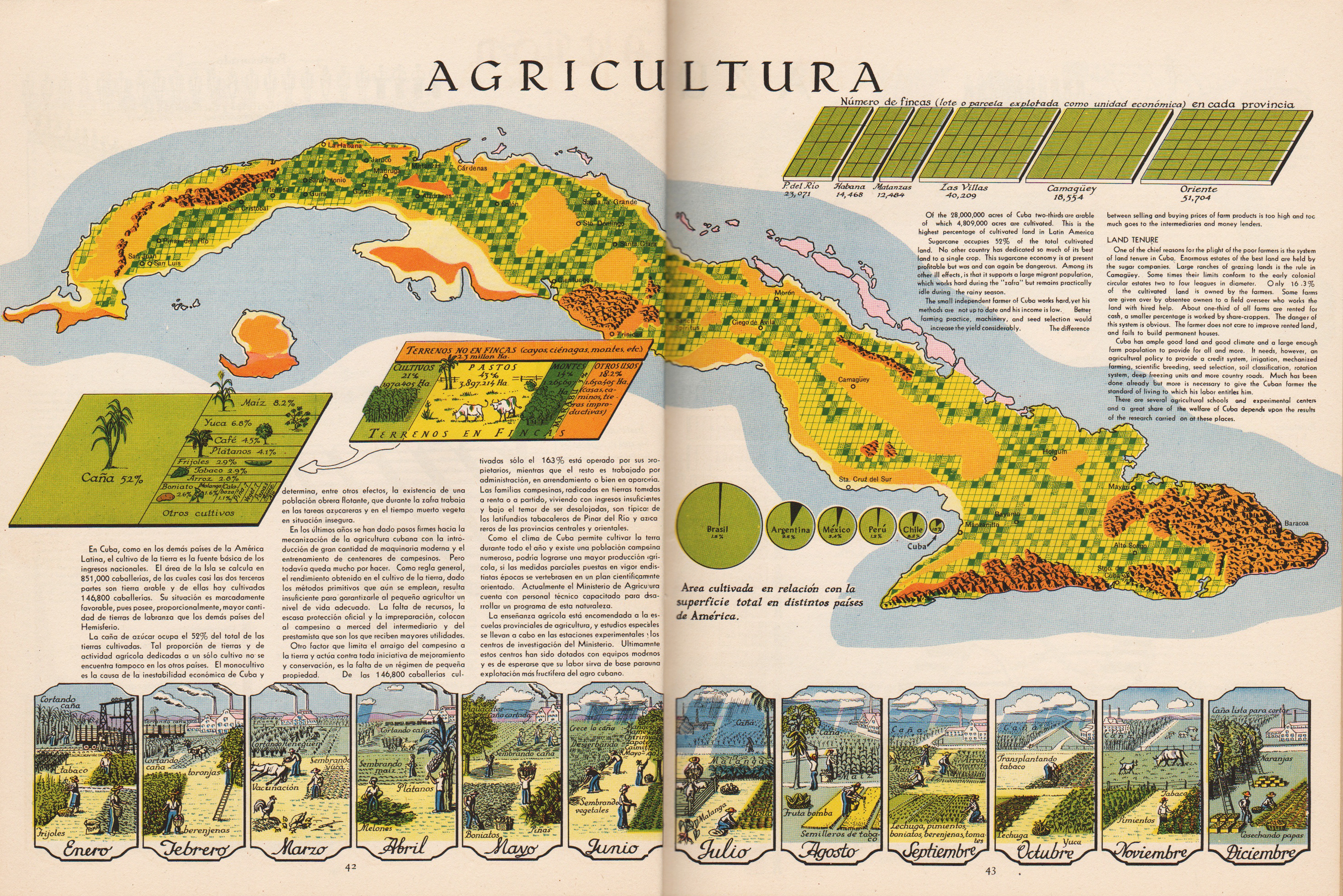
Agricultura | Agriculture (excerpts & entire pp. 42-43)
•••••••••••••••••••••••••••••••••
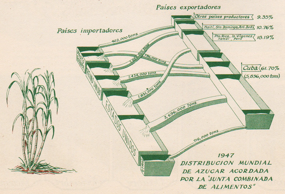
Azucar | Sugar (excerpt, p. 44)
•••••••••••••••••••••••••••••••••

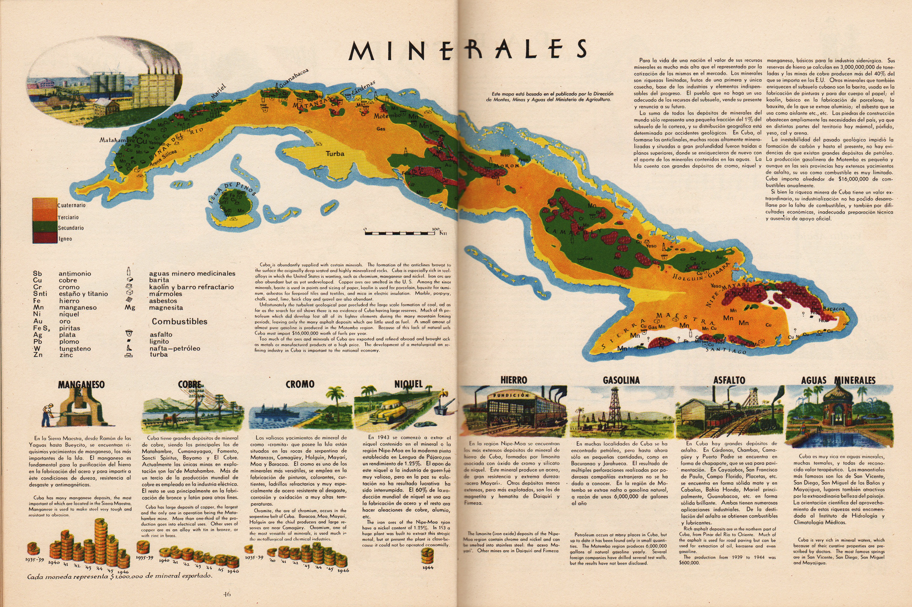
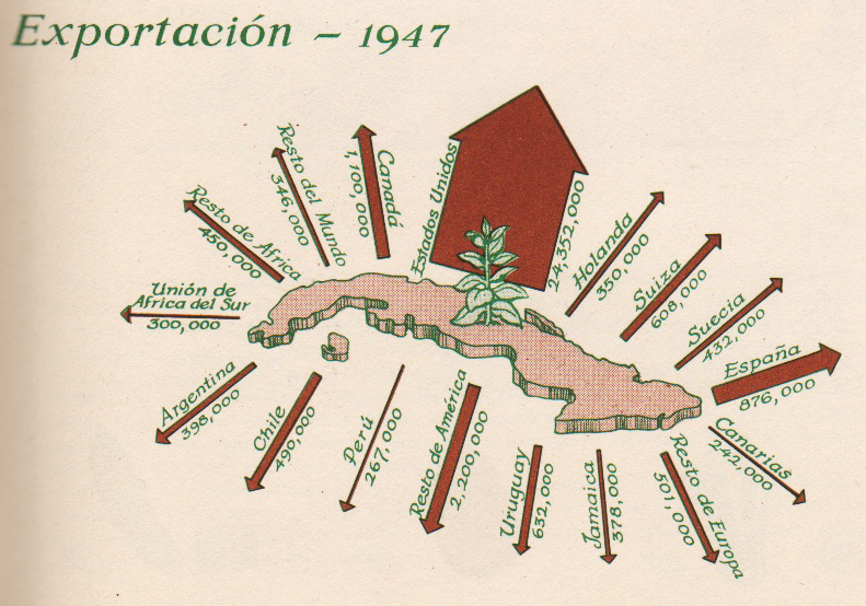
Minerales | Minerals (excerpt & entire pp. 46-47)
•••••••••••••••••••••••••••••••••
Tabaco | Tobacco (excerpt, p. 49)
•••••••••••••••••••••••••••••••••

Frutas | Fruit (excerpt, p. 51)
•••••••••••••••••••••••••••••••••
Atlas de Cuba
Garardo Canet & Erwin Raisz
Harvard University Press
1949
Japanese Maps | Tokugawa Era | 1600-1870
Posted in 01 What's A Map?, 02 Why Are You Making Your Map?, 09 Map Symbolization, 10 Type on Maps, 11 Color on Maps, Map History, tagged Maps - History, Maps - Japan - Tokugawa Era - history on May 28, 2014| 1 Comment »


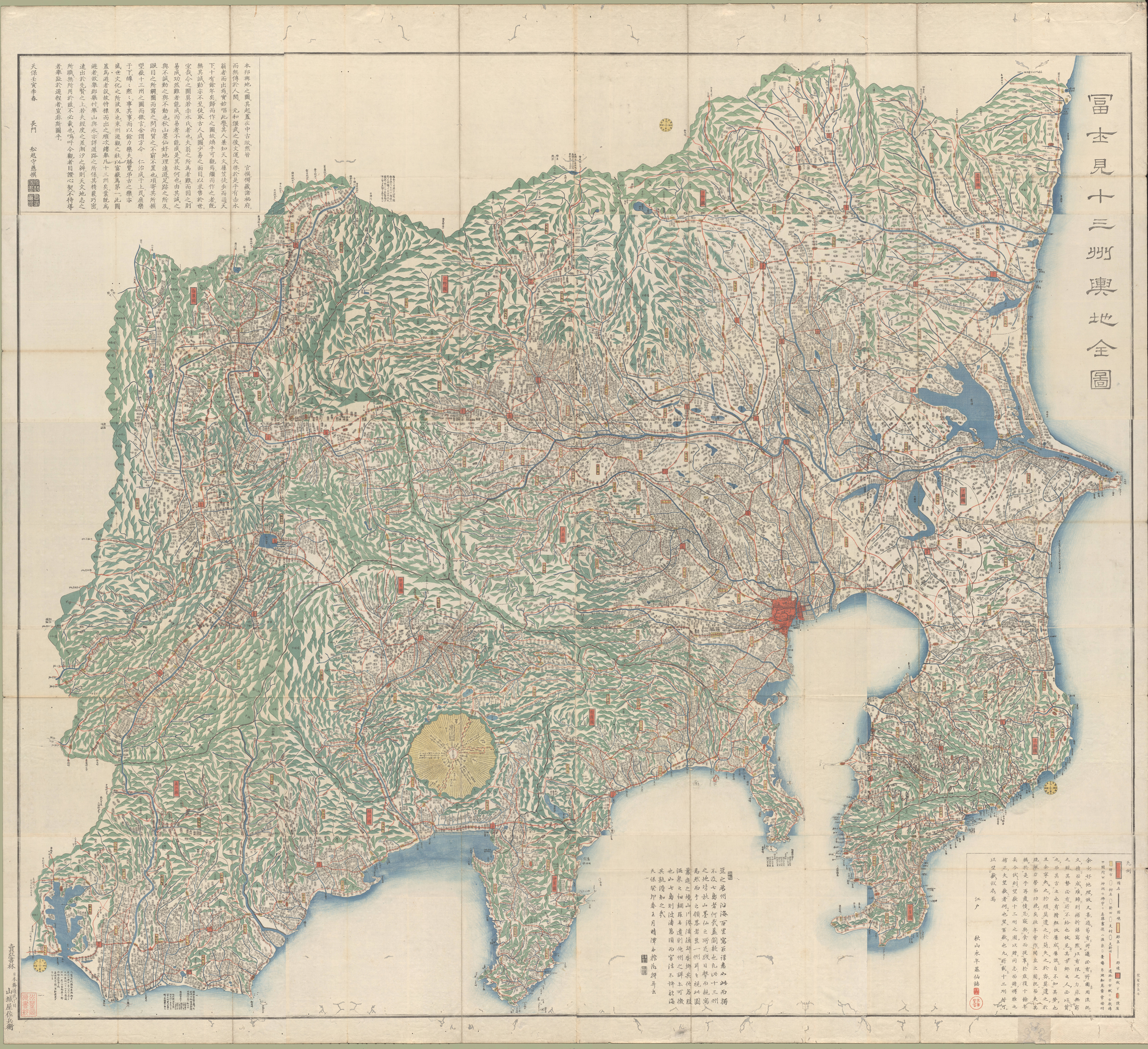
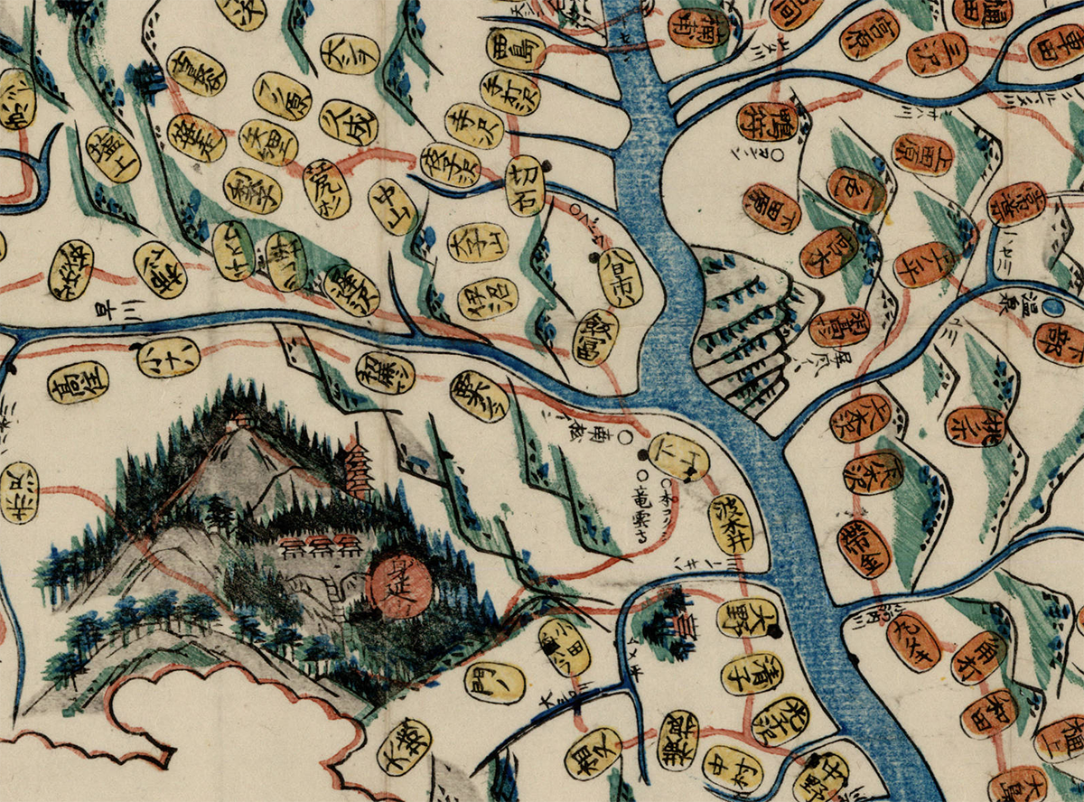
Fujimi jūsanshū yochi zenzu
(Map of the thirteen provinces from which Mt. Fuji is visible)
1843 | Edo : Yamashiroya Sahei
Source
••••••••••


Kaihō Kai no Kuni ezu
(Pocket map of Kai Province)
1842 | Kōfu, Kai Province : Murataya Kōtarō
Source
••••••••••


Ōsaka yori Tōkai ni itaru kairo no zu
(Tōkaidō and the sea route from Ōsaka to Edo)
1855 | Manuscript
Source
••••••••••
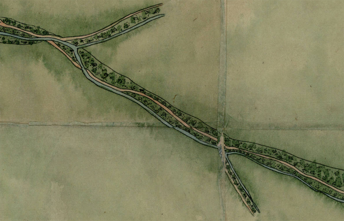
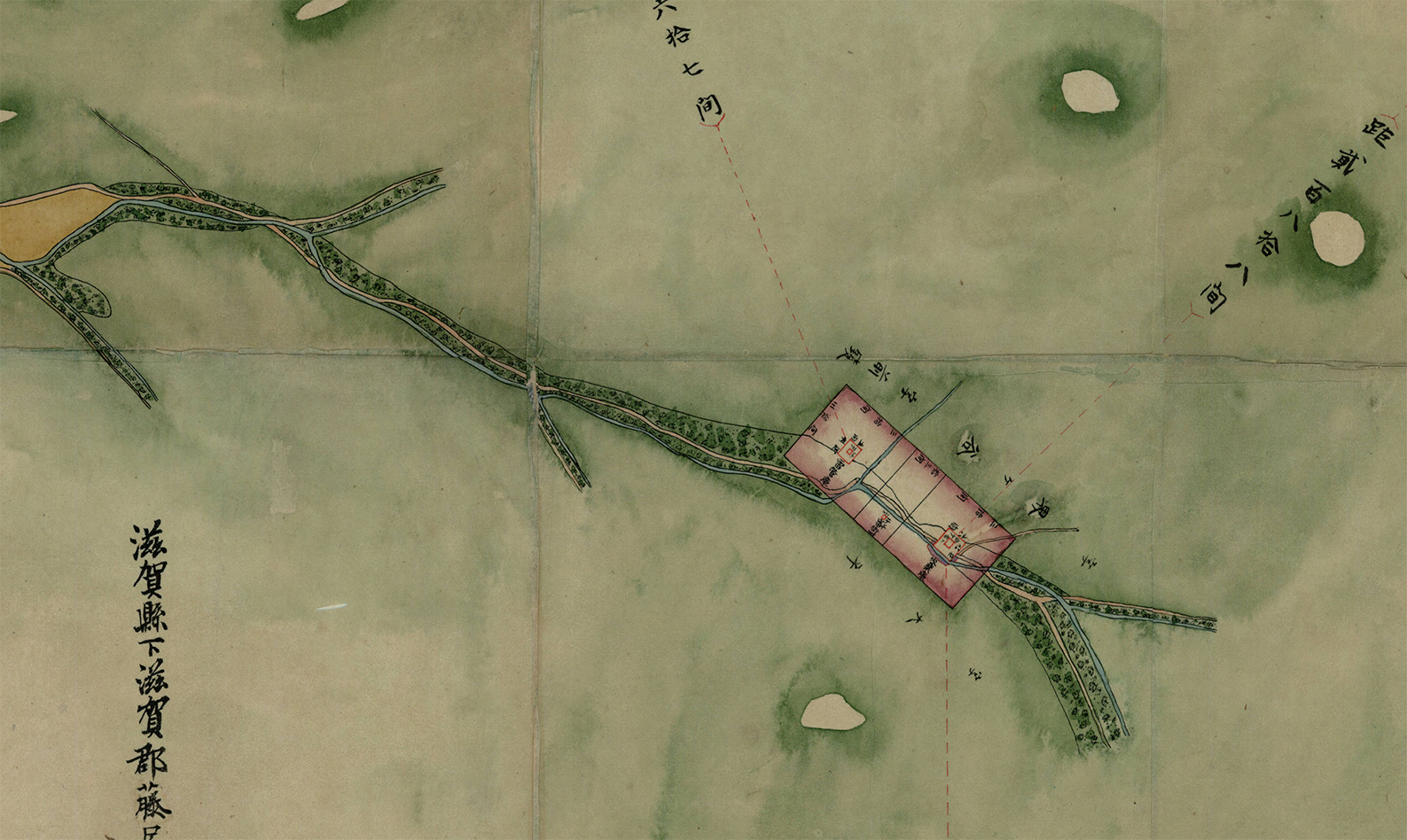

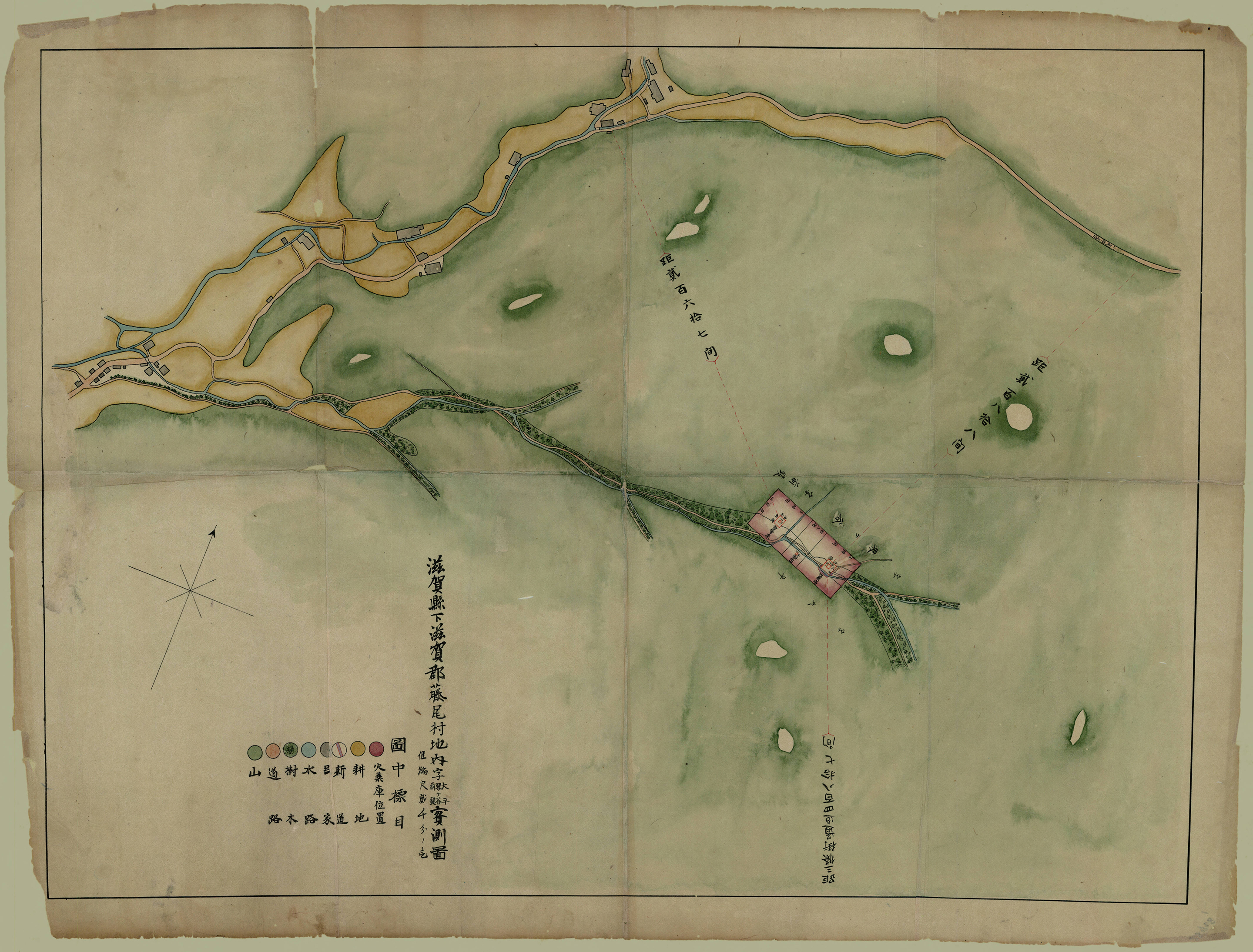
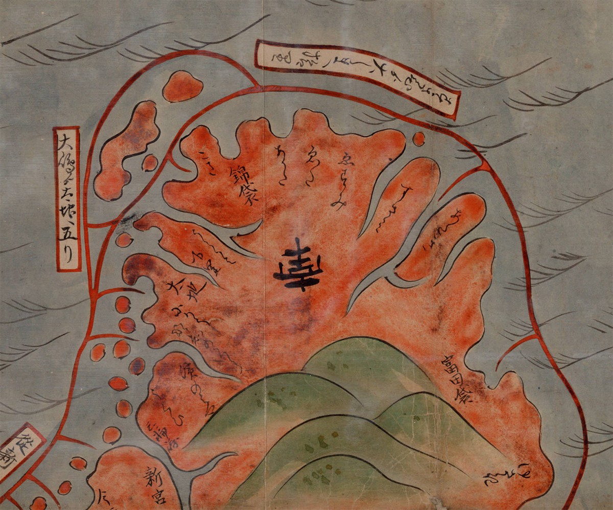
Shiga kenka Shiga-gun Fujio-mura chinai aza Ōhira Kaigaya Maegaki jissokuzu
(Measured map of Ōhira Kaigaya Maegaki, in Fujio Village, Shiga County, Shiga Prefecture – Gunpowder Safety Map)
1870 | Manuscript
Source
••••••••••
University of British Columbia
Collection: Japanese Maps of the Tokugawa Era
Source & Description
Map Poetry | Cupid’s Weather Map | 1907
Posted in 01 What's A Map?, 02 Why Are You Making Your Map?, 10 Type on Maps, Map Cartoons, Map History, tagged Maps - Poems, Maps - Weather - Poems on March 4, 2013| Leave a Comment »
The isotherms nestle together,
The isobars tenderly twine…

Cupid’s Weather Map
If Gladys had sent me no message,
Or the mail from Palm Beach met mishap,
Though I lacked premonition or presage
Or courage the wires to tap,
I am sure I could learn when she planned her return
From one look at the weather man’s map.
You’ll notice, no matter in what light
These loops and festoons you may view,
Wherever she moves, like a spot-light,
A zone of fair weather moves, too.
The breezes of May will be blowing her way
When our cars and our fingers are blue.
One sunshiny patch, set off clearly
In a country with rain-clouds all black,
To-day travels northward or nearly,
While a blizzard descends in its track.
Can I possibly err if from this I infer
That Gladys is on her way back?
No; the stupid old map of the weather
Tells the news in its tiniest line.
The isotherms nestle together,
The isobars tenderly twine,
While the forecast they print bears so rosy a tint
It well might be Cupid’s – or mine.
Philip Loring Allen
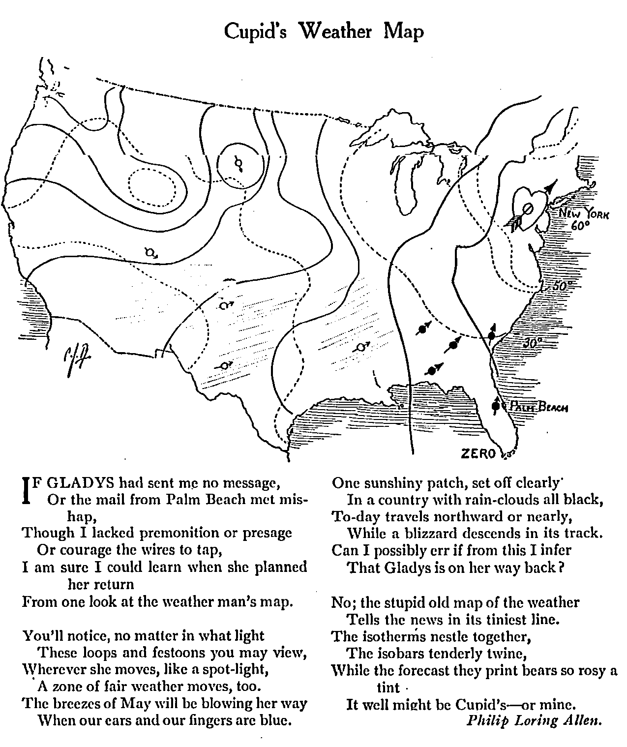
Life, February 28, 1907, p. 49
Map Design Annotated: 13 Voyager Maps from Making Maps 2nd Edition
Posted in 01 What's A Map?, 02 Why Are You Making Your Map?, 06 Map Layout, 07 Hierarchies, 08 Generalization & Classification, 09 Map Symbolization, 10 Type on Maps, Making Maps Book News, Maps Made, tagged Annotated Maps, Map Design, Maps - Annotated, Maps - Design on October 17, 2011| 1 Comment »

To understand map design, and how maps work, it is useful to see how map design concepts play out on a real map.
One of the significant updates to the 2nd edition of Making Maps was the inclusion of a map of the 1986 trans-global flight of the experimental aircraft called Voyager. This map, originally designed and created by David DiBiase and I back in 1987 for David Woodward’s map design course (and in the University of Wisconsin Cartographic Lab), is repeated thirteen times in seven of the chapters, annotated to show how the concepts and ideas in these chapters play out on the map.
The repeatedly annotated Voyager map serves as an example of map design in practice, but also a guide to “reading” a map from the perspective of map design.
Martin Dodge suggested the annotated maps be available together, for instructional purposes. A good idea! So here they are. Each individual map on this page is a 800k PNG file (click for full size).
A PDF file (8.8mb) with all thirteen higher resolution TIFF images is available here.
The Voyager map project was quite a bit of fun to create back in the day. It won a map design award, was published in the book about the Voyager flight, and printed on paper as part of a promotion for the Waukesha County, Wisconsin Airport. I cannot imagine anything much more exciting than that.
••••••••••
The second map in the series prefaces the initial chapter in Making Maps 2nd edition, and poses a series of questions that will be addressed in future chapters (and annotated Voyager maps):

Chapter 2, What’s Your Map For?, sets the context of the map (and of its re-creation for the book) and how such context shapes the design of the map:

Chapter 6, The Big Picture of Map Design, repeats the Voyager map five times, focusing on the key map design concepts covered in the chapter. This is where the map flips orientation south up (a controversial design choice, according to some reviewers: good! Think about why such a choice is controversial, and if it should be [or ask your students to do so]):

South is now up (so the story reads from left to right):

Annotations about map pieces including title, scale, explanatory text, legend, directional indicator, border, sources, credits, and insets & locator maps:

Annotations about visual arrangement including path, visual center, balance, symmetry, sight-lines, and grids:

Annotations about graphical excellence, based on Edward Tufte’s ideas, including complexity, detail, design variation & data variation, context, revision, non-data ink, data-ink ratio, explanatory text, editing, chartjunk & map crap, redundancy, and multivariate data:

Chapter 7, The Inner Workings of Map Design, reveals the Voyager map with no visual differences (a confusing mess of lines and type):

The map with visual differences is then annotated, with regard to key methods for establishing visual differences, including detail, edges, texture, layering, shape, size, closure, proximity, simplicity, direction, familiarity, and color:

Chapter 8, Map Generalization and Classification, annotates the Voyager map in terms of the generalization concepts of selection, dimension change, simplification, smoothing, displacement, and enhancement:

Chapter 9, Map Symbolization, annotates the map in terms of the visual variables: shape, size, color hue, color value, color intensity, and texture:

Chapter 10, Words on Maps, annotates the Voyager map with regards to typographic variables including typeface, type form, type weight, and type size:

I have a few ideas for additional annotated Voyager maps (such as a full color map) which I hope to cobble together in the future. If you have any other ideas for variations that might be useful or interesting, let me know.
Word Maps | Words on Maps | Map Typography
Posted in 09 Map Symbolization, 10 Type on Maps, tagged Cartography - type, Cartography - words, Map Lettering, Maps - words, Maps- South America on January 31, 2011| 8 Comments »

Click map for larger version; full version (7.3 mb PDF) here
The beauty of words on maps is often not evident, embedded, as they are, in an array of other symbols. A “word map” of South America (above), published by the Geographical Press in 1935, consists entirely of hand-lettered words. The map is supposed to show the labeled landforms of South America; this copy was erroneously printed without the landforms. The map is another find from the dusty old Departmental archives here at Ohio Wesleyan.
The South America word map is not that dissimilar from the word map poetry of Howard Horowitz: below, Manhattan:

A few examples of “word maps” or “typographic maps” have recently popped up on the internets.
National Geographic’s What’s in a Surname (below) interactive map of the dominant surnames in different parts of the US (upper Midwest, and Southwest) reveal structure (the form of the US is evident) as well as meaning (variations in ethnicity across the US).


Axis Maps Typographic Map series works in much the same way, but at a different scale and in a bit more complex manner:

Chicago Typographic Map (Axis Maps)

Boston Typographic Map (Axis Maps)
The Axis Typographic Maps use typography as line and area map symbols, providing a nuanced exposition of the geography of these places, the grid of Chicago or the meandering roads of Boston. Again, both meaning and structure are generated by words alone.
But back to the old South America map…
The South American map follows the typical “rules” about type placement, worked out in practice throughout the last few hundred years, and now embedded in cartography texts and in automatic text placement algorithms in GIS software. These rules will, in most cases, make the map easier to read and understand. On the excerpts of the South America map below
- City names are mixed caps/lower case, roman, and horizontal
- Country names are upper case, horizontal, and spread out to define the areas
- Natural features are in the more flowing italics form; if referring to a point, they are horizontal, if they refer to linear or area features (rivers, regions) they are curved to fit the feature.
In practice, placement is complicated, as words cross other words, wrap around each other, and (on most maps) vie for space with other map symbols. The South America map has some neat examples of the art of placing words on maps:

The size of the words varies – suggesting large areas, or places of more importance.


Below find a few pages from the new (2nd) edition of Making Maps (2011) on type as a map symbol. These pages show how typography can be used to express both qualitative and quantitative characteristics of the data they stand for on a map. Typographic guidelines on these pages include typeface (font), type size, type weight, and form (including italics, roman, color, case, and spacing).


1910 | Topographic Maps | Map Symbols | Egypt
Posted in 06 Map Layout, 07 Hierarchies, 09 Map Symbolization, 10 Type on Maps, 11 Color on Maps, Cartominutiae, Map Music, tagged Desert Maps, Egypt - maps, Empty maps, History of Cartography, Map Symbols - history, Maps - History, The Survey of Egypt on November 2, 2010| Leave a Comment »

The Survey of Egypt, 1910, 1:1,000,000, Sheet 5 (detail 1, close-up)
•••
Found while cleaning out an old map cabinet: oceans of just about nothing, punctuated by signs of a minimal landscape. Soiled, creased, tears, dusty. Thumb-print and fading pencil marks, from someone who stared at this map a long time ago.
Details from a topographic map of Egypt in 6 sheets, published by The Survey of Egypt in 1910, scale 1:1,000,000.
Click on any map for a larger version of the scan.
•••

The Survey of Egypt, 1910, 1:1,000,000, Sheet 5 (detail 1)
•••

The Survey of Egypt, 1910, 1:1,000,000, Sheet 1 (detail 1)
•••

The Survey of Egypt, 1910, 1:1,000,000, Sheet 1 (detail 2)
•••

Note the type leaking over the map border (Mediterranean, Lake Borollos, Gharbia)
The Survey of Egypt, 1910, 1:1,000,000, Sheet 1 (detail 3 – close-up)
•••

Note the type leaking over the map border (Mediterranean, Lake Borollos, Gharbia)
The Survey of Egypt, 1910, 1:1,000,000, Sheet 1 (detail 3)
•••

The Survey of Egypt, 1910, 1:1,000,000, Sheet 3 (detail 1 – close-up)
•••

The Survey of Egypt, 1910, 1:1,000,000, Sheet 3 (detail 1)
•••

The Survey of Egypt, 1910, 1:1,000,000, Sheet 5 (detail 2)
•••

The Survey of Egypt, 1910, 1:1,000,000, Sheet 6 (detail 1)
Mapping with Isotype
Posted in 02 Why Are You Making Your Map?, 06 Map Layout, 09 Map Symbolization, 10 Type on Maps, 11 Color on Maps, Map Books, Map History on February 17, 2009| 16 Comments »


I was moving some piles of junk in a storage room and came across a 1934 U.S. Public Works Administration book on Mississippi Valley public works projects (Report of the Mississippi Valley Committee of the Public Works Administration, October 1, 1934). The book is full of maps and other information graphics influenced by Otto Neurath, Gerd Arntz, and Marie Reidemeister’s picture language, isotype.
I always thought isotype had a great look to it. Its context, in Vienna Circle logical positivism, is a bit wonky, and the idea that symbols – if designed carefully enough – could be “universally communicable” across all cultural and social differences, is merely the dream of those born with a peculiar neurology. Nevertheless, the isotype “look” is cool in a retro sort of way, and it has certainly influenced the current spare design ethos in cartography.
Some annotated examples of the isotype “language” from a 1937 article by Neurath:


The Gerd Arntz Web Archive is a spectacular collection of thousands of isotype symbols designed by Arntz. All seem to be free to use. (symbols are copyrighted by Pictoright – thanks to Jonathan Hunt for pointing this out). The site also has a breif biography of Arntz.


In casting about the internets, I was gladdened to find someone had scanned the isotype classic, Atlas of Gesellschaft und Wirtschaft (1930, 14+mb PDF). As far as I know the atlas was printed (on sheets) in limited numbers and has never been easy to find. Sybilla Nikolow discusses the atlas in her article “Society and Economy: An Atlas in Otto Neurath’s Pictorial Statistics from 1930.” (PDF)
A sampling of maps and graphs from the Atlas follows, and a few more useful isotype resources can be found way at the end.


•••••
A few interesting isotype resources:
The Isotype Institute documents the history of isotype and has much useful information.
A snazzy discussion of isotype done up by mixing isotype and text is Modern Hieroglyphics. (PDF)
Ellen Lupton reviews the history and significance of isotype in her article “Reading Isotype.” (PDF)

Neurath and the Vienna Method of Picture Statistics (PDF). A chapter out of an e-book called Speaking of Graphics An Essay on Graphicacy in Science, Technology and Business by Paul J. Lewi. Seems like a nice overview of the history of isotype and its characteristics.
The DADA Companion has much information on design and art related to isotype. Search for “isotype” or “Neurath.”
A new book to be published in April of 2009 is called The Transformer: Principles of Making Isotype Charts by Marie Neurath and Robin Kinross.
Austin Kleon’s blog on graphic design has a nice posting on isotype, comics, and information graphics design. Search the blog for other isotype references.
The web magazine Mute has a feature called The Dutch Are Weeping in Four Universal Pictorial Languages At Least that reviews a series of contemporary exhibits that focus on isotype and related ideas. One exhibit called After Neurath has a significant amount of information and links.
The New York Times summarized 2007 US and Coalition member deaths in Iraq in a isotype-esque chart (click for larger version):

Stroom De Haag writes (in the online magazine Archined) about Neurath as the “grandfather of open source.”
Working Maps: 17th-19th Century French Manuscript Maps
Posted in 02 Why Are You Making Your Map?, 09 Map Symbolization, 10 Type on Maps, 11 Color on Maps, Map History, tagged History of Cartography, Map Design, map symbols - farm fields, map symbols - French - 17th-19th century, map symbols - geology, map symbols - hunting grounds, map symbols - prehistoric sites, map symbols - property, map symbols - rivers, map symbols - terrain, map symbols - trees & forests, maps - manuscript on February 3, 2009| 6 Comments »


Prähistorische Karte von Südwestdeutschland und der Schweiz, 1879
(Protohistoric and Prehistoric Discoveries …)
Looking at working maps – manuscripts, field sketches, and provisional maps – reveals a diversity of symbolization and design which are lost in the monoculture of finished, standardized maps.
HistCarto brings together more than 4000 17th-19th century French manuscript maps. All are working maps, and most are hand drawn. Most contain signs of assessment:
These “signs of assessment” include textual commentaries or the addition of symbols, which provide some indication of the ways the maps were made or the uses to which they were put in an administrative or military capacity.
Map symbols and topics shown here include prehistoric sites, farm fields, trees and forests, rivers, hunting grounds, geology, terrain, and property parcels.
The site is in French. Once at the site, click on the Acces a la base link on the right. Then select Recherche (on the left) and Simple. I tried to link each of the maps below to its page at the HistCarto site, but you must be logged into the site for the links to work. Not optimal! So I removed the links. To find the maps, just search the site using the map’s title (below each map).
•••
Detail, farm fields near Neuhof forest (1787):

Plan de la forêt du Neuhof
•••
Detail, farm fields near Poppenreuth (1795):

Mappa Geographica Parochiae Poppenreutensis
•••
Detail, farm fields near Strasbourg (no date):

Carte des environs de Strasbourg
•••
Detail, farm fields near Herlisheim (1760):

Projet d’une nouvelle route entre Gambsheim et Drusenheim
•••
Details, trees, Château de Karlsruhe (no date):

Plan du château de Karlsruhe
•••
Detail, forests near Molsheim (no date):

Plan de Molsheim
•••
Detail, forests near Mont Sainte Odile (1810):

Les environs du Mont Sainte-Odile
•••
Detail, forests near Thann (1815):

Lever à Vue de la Ville de Thann et des Montagnes qui l’environnent
•••
Drachenkopf Forest, detail and full map (no date):


Forêt de Drachenkopf
•••
Detail, map of Strasburg (1765):

Plan de Strasbourg en 1765
•••
Hunting grounds in the vicinity of Strasbourg, reserved for the king and officers (1739):

Terrains de chasse aux environs de Strasbourg
•••
Revision on Geologic Map, Barr Region (no date):

Région de Barr: Carte Géologique
•••
Detail, hand-drawn map of Euphrates (no date):

The river Euphrates with the Cilician Taurus and Northern Syria
•••
Detail, terrain near Munster (no date):

Carte des Vosges depuis Belfort jusqu’à Landau
•••
Detail, terrain on map of mining concessions near Thann and Dauendorf (1705):

Concessions minières dans les environs de Thann et de Dauendorf
•••
Map showing two roads linking Wissembourg and Fischbach and a new road (in yellow) (no date):


Deux routes reliant Fischbach et Wissembourg
•••
Parcels in a portion of municipal Nordheim (1782):

Portion du communal de Nordheim
321 Definitions of “Map”
Posted in 01 What's A Map?, 10 Type on Maps, Map History, tagged Map Definitions, What is a Map?, Word Clouds on November 25, 2008| 10 Comments »

What is a map?
J.H. Andrews compiled 321 definitions of “map” for a 1996 article (“What Was a Map?” Cartographica 33:4, pp. 1-11). A copy of that paper is available here.
Edit out all the source information and other miscellaneous stuff and you have a bunch of words that can be pumped into a word cloud generator like the late, great Wordle. (search for alternatives including Wordart.com
The word cloud visualization does help to make some sense out of the 8106 words in the 321 definitions. At least we know what we think maps are.


•••
321 Definitions of “Map” are below, first without the citation information (to copy and paste into a word cloud app). The definitions, numbered and with the citations follow.
•••
The terrestrial or earthly globe is an artificial representation of the earth and water under that form and figure of roundness which they are supposed to have, describing the situation, and measuring the compass of the whole frame, and describing the situation and measuring the distances of all the parts. As the earth and water are wholly represented upon the globe, so the whole, or any part of either may be described in plano, or upon a plane surface in a map or sea-chart. It was said before that as the whole earth upon the globe, so the whole or any part thereof may be described upon a plane.
A schedule containing a description of the world, &c.
A representation of the whole globe of the earth, or of some particular country upon a plan, or plain superficies.
A representation of the globe of the earth, or of some of its parts, upon a plan or plain superficies.
A description of the earth, or some particular part thereof, projected upon a plain superficies; describing the form of countries, rivers, situation of cities, hills, woods, and other remarks.
The resemblance of the heavens or the earth on a plane superficies.
A description of the earth, or some particular part thereof, projected upon a plain superficies; describing the form of countries, rivers, situation of cities, hills, woods and other things of note.
A representation of the earth or some particular part thereof upon a plain superficies. A general map is a description of the whole earth, with the several countries, islands, seas, rivers, &c. therein contained, and also the circles of the globe. Particular maps, are either of the four parts of the world; or of particular kingdoms and countries.
A representation of the earth, or some part of it, on a plane superficies. A general map in geography is a description of the whole earth, with the several countries, islands, seas, rivers, &c. therein contained, and also the circles of the globe. Particular maps, are either of the four parts of the world; or of particular kingdoms and countries.
The problem of composing geographical maps: the situation of an infinite plain, or one to be produced at pleasure, being given, to represent in that the places of the superficies of the earth, according to the rules of perspective. The end of these tables or maps is to the life, and exactly as may be to express the scituation of places in the superficies of the earth; maps of small regions do not require the rules of perspective.
A plain figure, representing the several parts of the surface of the earth, according to the laws of perspective, or it is a projection of the surface of the globe, or part thereof in plano, describing the several countries, islands, seas, rivers, with the situation of cities, woods, hills etc. Universal maps, such as exhibit the whole surface of the earth, or the two hemispheres. Particular maps, are such as exhibit some particular part or region thereof.
A representation of the whole earth, or some part of it, upon a plain superficies.
A description or projection of either the whole world or a part of it upon a plane, in which the situation, figure &c. of a country, both in respect to its own absolute possession of a particular space, or in relation to the bordering nations about it, is described according to the laws of perspective.
A representation of the whole, or a part of the earth, upon a plane superficies, describing the situation and form of countries &c.
A geographical picture on which lands and seas are delineated according to the latitude and longitude.
A geographical picture, or a projection of the globe, or a part thereof, on a plain surface, representing the forms and dimensions of the several countries, rivers, and seas, with the situation of cities, mountains, and other places, according to their respective longitude and latitude.
A geographical picture, or a projection of the globe, or a part thereof, on a plain surface, representing the forms and dimensions of the several countries, rivers, and seas, with the situation of cities, mountains, and other places, according to their respective longitude and latitude.
Ichnographical descriptions of the earth, which we call.
Maps differ from a globe as a picture from a statue.
A plain figure, representing the surface of the earth, or a part thereof, according to the laws of perspective.
A geographical picture, or a projection of the globe or any part thereof on a plain surface, representing the forms and dimensions of the several countries, rivers, and seas, with the situation of cities, mountains, and other places, according to their respective longitude and latitude.
A description of a country by lines drawn on paper, a picture on which lands and seas are delineated according to the rules of geography; the site or description of an estate according to exact admeasurement.
A kind of pictures which should accurately represent all the different parts of our earth.
A plane figure representing the surface of the earth, or a part thereof, in reduced scale.
A plain figure, representing the surface of the earth, or a part thereof, according to the laws of perspective.
A projection of the surface of the globe, or a part thereof; representing the forms and dimensions of the several countries and rivers; with the situations of cities, mountains, and other places.
A geographical picture on which lands and seas are delineated according to the longitude and latitude.
A geographical picture on which lands and seas are delineated according to the longitude and latitude; a description of a country by lines drawn on paper; a view of an estate according to exact measurement.
A plain figure, representing the surface of the earth, or a part thereof, according to the laws of perspective.
A geographical picture upon which lands and seas are delineated according to the longitude and latitude, a chart; the site and description of an estate according to exact admeasurement.
A delineation of lands, seas, countries etc.
Delineations of the earth’s surface on a plane; on which the form and boundaries of the several countries, and the objects most remarkable in each, whether by sea or land, are represented according to the rules of perspective, so as to preserve the remembrance that they are parts of a spherical surface.
A geographical picture, or a projection of the globe, or part thereof, on a plain surface, representing the forms and dimensions of the several countries, rivers, and seas, with the situation of cities, mountains, and other places, according to their respective longitude and latitude.
A lineal representation of countries in their just proportions.
A plane figure, representing the surface of the earth, or a part thereof, according to the laws of perspective.
A delineation or picture of some part of the earth’s surface: and hence of the heavens.
The delineation of the earth’s surface on a plane, by which means the whole or any portion may be easily represented, on a greater or less scale according to circumstances.
A delineation, on a plane surface, of some portion, or the whole, of the celestial globe.
A geographical picture on which lands and seas are delineated according to the longitude and latitude.
A projection, on a plane surface, of the whole or part of the spherical surface of the earth.
A tablet, picture, or delineation of the world, or any part of it; showing the relative situation of places on the earth; of stars in the heavens.
A geographical picture on which lands and seas are delineated according to the longitude and latitude; a description of a country by lines drawn on paper; a view of an estate according to exact admeasurement.
A representation of the whole earth, or of a part of it, on a flat surface.
The representation of the earth, or part of it, on a plane surface.
A delineation of some portion of the surface of the sphere terrestrial or celestial on a plane.
A picture of the world, or of some part of it.
A representation of the earth, or of any part of it, on a flat surface.
A tablet, picture or delineation of the world, or of any part of it; showing the relative situations of places on the earth; of stars in the heavens.
In geography, a representation of the surface of the earth, or of any part of it, drawn on paper or other material, exhibiting the lines of latitude and longitude, and the positions of countries, kingdoms, states, mountains, rivers, etc.
A chart. Picture of the earth.
A delineation on a plane surface of the world in general, or of a city or river, giving its general form or geographical peculiarity.
A delineation of the surface of the earth on paper or other material, in which the lines of latitude and longitude, and the relative positions of countries, kingdoms, states, mountains, rivers, seas etc. are represented.
A delineation of some portion of a sphere, or of the earth, on a plane; a chart.
A delineation of the earth, or part of it.
Represents on a plane greater or smaller parts of the earth’s surface. Astronomy uses similar representations of objects visible in the firmament.
A delineation of the surface of the earth, or any part of it, exhibiting the lines of latitude and the relative positions of countries, mountains, seas, rivers etc.
A delineation of some portion of the surface of the sphere terrestrial or celestial on a plane.
A representation of the surface of a sphere, or a portion of a sphere on a plane. The name however is commonly applied to those plane drawings which represent the form, extent, position and other particulars of the various countries of the earth.
A representation of the whole earth, or of any part of it, on a flat surface.
A rude representation of the school-room, as it would appear to a person looking down from the ceiling or, in other words, a map of the schoolroom.
A showing of the shapes and positions of the features of the earth, not as they rise before the eye in all the beauties of the sun and air, and in their vertical, upright forms, but as they are stretched out horizontally at one’s feet.
A representation in miniature of part of the earth’s surface.
A representation of the surface of the earth or of any part of it, or of the whole or any part of the celestial sphere, usually drawn on paper or other material. A distinct and precise representation of anything.
A drawing upon a plane surface representing a part or the whole of the earth’s surface or of the heavens, every point of the drawing corresponding to some geographical or celestial position, according to some law, of perspective, etc., which is called the projection, or, better, the map-projection.
A plan or drawing of the whole or part of the earth on a flat surface.
If a person in a balloon passed at a great height over any part of the earth’s surface, and sketched in outline what he saw directly below, his sketch on a flat surface like this page would be called a map.
A napkin. A painted cloth said to be a Punic word. A delineation of some portion of a sphere, or of the earth, on a plane; a chart.
A delineation of a portion of the earth’s surface upn paper or other similar material according to scale, showing the proportionate sizes, shapes and relative positions of places.
A representation of the surface of the earth, or of some portion of it, showing the relative position of the parts represented usually on a flat surface. Also such a representation of the celestial sphere, or of some part of it.
A representation of the earth or part of it.
A flat representation of the earth’s surface.
In one sense a picture expressed in definite and condensed symbols, every one of which is full of meaning.
A map of the simplest kind represents all the points of one surface by corresponding points of another surface in such a manner as to preserve the continuity unbroken, however great may be the distortion.
In a convenient shape, and on a small scale, such a picture of the country represented as will convey a real idea of the actual country as it exists.
A representation of the earth’s surface, or a part of it, its physical and political features, etc., or of the heavens, delineated on a flat surface of paper or other material, each point in the drawing corresponding to a geographical or celestial position according to a definite scale or projection.
A representation of the surface of the earth or any part of it, drawn on paper or other material, exhibiting the lines of latitude and longitude, and the positions of countries, kingdoms, states, mountains, rivers etc..
A delineation on a plane of the whole or of a portion of the surface of the earth.
A representation, as a plane projection, of any region or expanse; a chart; specifically, a delineation of land or land and water, showing the extent and relative position of geographical features and conveying topographical or other information.
Portrayal on a plane of the surface of the earth or some larger or smaller portion of it.
A picture of the earth, or part of it, on a flat surface.
A representation, on a plane and a reduced scale, of part or the whole of the earth’s surface.
Most commonly represents in a conventional manner a portion of the earth’s surface, somewhat as it would be seen by an eye directly above it, but with additions which render it a summary of observations made on the spot.
A delineation of the earth or any part of it.
A picture drawn on a flat piece of paper of a portion of the earth’s surface and giving a similar view of the earth to that presented to an observer in the car of a balloon floating in the air.
A reproduction or picture of some portion of the earth’s surface differing materially from an ordinary picture for two reasons: in a map objects are represented as they would appear if seen from a great height, such as would be obtained by an observer in an aeroplane; everything on a map must either be named or marked with a distinguishing symbol.
Essentially, a representation on paper of a portion of the earth’s surface.
A representation of the whole, or a portion, of the earth’s surface upon a plane.
A representation of a portion of the earth’s surface, or the heavens, on a plane.
A representation, generally on a flat surface, of the face of the earth or a part of it, or the celestial regions.
A delineation on a plane of the surface of the earth or heavens, or a portion thereof.
A plan of a portion of the curved surface of the earth represented on a plane surface.
A pictorial representation of a portion of the earth’s surface laid down on a flat surface.
Simply a model of a portion of the earth’s surface ideal map.
A representation of the whole earth, or of any part of it, on a flat surface.
A representation on a plane surface of a part or the whole of the surface of the earth or of the heavens.
An abstract of the main features of a country, laid before the traveller in advance of his experience of the country itself.
A representation of the whole or part of the earth’s surface drawn on a plane surface.
A representation of the whole or a part of the earth’s surface.
A representation usually on a flat surface of the surface of the earth, or of some portion of it, showing the relative position, according to some given scale and projection, of the parts represented; also such a representation of the celestial sphere, or some part of it.
Plane representation of the earth’s surface or a part of this, indicating physical features, political boundaries etc. Similar representation of heavens, showing position of stars etc.
A delineation on a plane of the surface of the earth or heavens, or a portion thereof.
A representation of the surface of the earth or of any part of it, drawn on paper or other material.
Flat representation of the earth or some part of it, or of the heavens.
A representation on a plane of a part or the whole of the surface of the earth, or the heavens.
A plane representation of a greater or smaller part of the earth’s surface, emphasising, in addition to the positional relations, also space and surface relations, and further geophysical, natural and cultural facts, in such a way that it enables their reading and measurement.
Any delineation of the surface of the earth, or any part of it, drawn on paper or other material.
A representation on a plane surface of a part or the whole of the surface of the earth or of the heavens.
A representation on a plane of a portion of the surface of the earth or the heavens.
Representation on a plane surface of the earth or some part of it.
A representation of the features of one surface on another.
A plan is the shape of any object or group of objects as they would appear if seen from above. Maps are plans on small scales, taking in large areas.
The outcome of man’s desire to give geographical expression to his knowledge or his ideas concerning the characteristics and distribution of the earth’s features.
Representation of the earth or some portion of it on a plane surface.
Representations on a plane surface of some part of the earth.
Plane representation of whole or part of earth’s surface, showing physical features, political boundaries etc..
A representation of a portion of the earth’s surface, or the heavens, upon a plane.
A representation of the surface of the earth or of part of it, on any plane surface; a representation of the celestial sphere.
Flat representation of the earth or some part of it, or of the heavens.
Intended to be a miniature of the country it represents, in so far as a flat surface can imitate one that is actually in relief.
A representation of any region, as the earth’s surface.
Reduced conditional representations of the surface of the whole or parts of earth’s sphere on a plane, obtained by means of a projection and rendering essential features of the geographical characteristic of this surface with all possible fullness and evidence.
A representation of the physical, political, or other features of a geographical area, put down on paper or other flat surfaces according to a definite scale.
A flat representation of the earth’s surface.
Flat representation of the earth or part of it.
Graphic presentation of our knowledge of the earth’s surface and its varied features.
A small-scale, flat-surface representation of some portion of the surface of the earth.
In its primary conception, a conventionalised picture of the earth’s pattern as seen from above, to which lettering is added for identification.
A picture or chart of part of the earth’s surface.
A representation, usually a plane projection, of any region or expanse; a chart; specifically, a delineation of land or land and water, showing the extent and relative position of geographical features, and conveying topographic or other information.
A represenation of spatial phenomena of a certain portion of the earth, projected on a plane; in comparison with a picture it constitutes an abstraction of the reality, represented by means of points, of lines and of superficial markings.
A chart, a flat representation of the earth or a particular region.
A representation in outline of the surface features of the earth, the moon etc., or part of it, usually on a plane surface; a similar plan of the stars in the sky.
A representation on a plane of a part or the whole of the surface of the earth, or the heavens.
Any delineation of the surface of the earth, or of any part of it, drawn on paper or other material.
A flat drawing of the earth’s surface or part of it.
By definition, a representation of all, or a portion of, the earth, drawn to scale and usually on a plane or flat surface.
A graphic document in which location, extent, and direction can be more precisely defined than by the written word.
The purpose of a map is to express graphically the relations of points and features on the earth’s surface to each other.
A complete picture of the countryside it represents, including hills and valleys, railways and roads, rivers and villages, and all the other features of interest.
A representation on a plane surface, at an established scale, of the physical features, natural, artificial or both, of a part or the whole of the earth’s surface, by the use of signs and symbols, and with the method of orientation indicated. Also a similar representation of the heavenly bodies.
Graphic representations of parts of the earth’s surface in miniature, incorporating selected information on a flat surface.
A representation of a portion of the earth’s surface, or the heavens, upon a plane.
A picture of the ground, looked at from above, drawn with painstaking accuracy.
The representation on a flat surface of all or a part of the earth’s surface to show physical, political, or other features, each point on the diagram corresponding to a geographical position according to a definite scale or projection.
A scale drawing of a part of the earth. Pictures of areas of the ground showing its shape, the location and types of roads, railroads, buildings, landmarks, woods, swamps, rivers, lakes and so on; instead of showing the land from the ground level, as you would ordinarily see things, the map gives a view from overhead; maps are picture drawings. They are drawings of the ground and the important things on the ground.
A delineation of the earth’s surface or any part of it.
A one-view drawing showing only the top view.
A flat representation of the earth or some part of it or of the heavens.
A lineal representation on a plane surface of spatial distributions usually on the earth, but sometimes the heavens or a heavenly body. It symbolises sphericity by using projections, distance by using a scale, relief by contours, and employs conventional signs for other features.
A representation of the earth or part of it, or of the heavens.
A representation on a flat surface of all or part of the earth’s surface.
A simplified picture or plan of part of the earth’s surface.
Reduced, generalised, mathematically defined representations of the earth’s surface, showing the distribution, the state and the mutual relations of various natural and social phenomena, chosen and characterised in accordance with the purpose of the map.
Represents the features of a piece of country all to the same scale, correct in their lateral disposition and orientation.
Geographical records and pictures of the way to get from place to place.
A representation of the earth’s surface or a part of it, its physical and political features, etc., or of the heavens, delineated on a flat surface of paper or other material, each point in the drawing corresponding to a geographical or celestial position according to a definite scale or projection.
A flat drawing of the earth or some part of it, showing mountains, rivers, etc.
A representation on a plane surface of the earth’s surface or a portion thereof, or the heavens.
A pilot’s eye view of the ground drawn on paper.
A selective, symbolised, and generalised picture on a much reduced scale of some spatial distribution of a large area, usually the earth’s surface.
A representation of the surface of the earth or any part of it or of the whole or any part of the celestial sphere, usually on paper or other material.
A proportional representation of a particular area of the earth’s surface on a plane, in which certain conventions are used.
A drawing of a large surface. The surface may be of a town, country, the world, the moon or the appearance of the sky.
Representation of the earth’s surface or of the heavens.
The chief difference between a map and a picture is that a map shows the outlines of things as they appear from above.
A conventional representation, normally to scale and usually on a flat medium, of a selection of material or abstract features on or in relation to the surface of the earth, or of a heavenly body.
A representation of the earth’s surface on a reduced scale.
A representation usually on a flat medium of all or a portion of the earth or other celestial body, showing the relative size and position of features to some given scale or projection; also, a representation of all or part of the celestial sphere.
The representation of a flat surface of all or part of the earth’s surface, to show physical, political or other features, each point on the diagram corresponding to a geographic position according to a definite scale or projection.
A graphic is a geographic map when the elements of a geographic component are arranged on a plane in the manner of their observed geographic order on the surface of the earth.
A portable, simplified picture of the world or some portion of it.
A topographic transfer, relative to a given part of the earth surface, is a set of signs informing about spatial relations conditions occurring between objects or phenomena connected with the said part of the earth surface. The map of a given part of the earth surface is a topographic transmitter that informs only and solely by means of a disposition on the plane of signs designating objects or phenomena.
A symbolised picture of an area or piece of ground, drawn as accurately as possible, as it would be seen from directly above.
The primary function of a map is to serve as a reduction of all or part of the earth’s surface for the purpose of recording, presenting, or analysing the spatial positions and the interrelationships of phenomena occurring thereon.
A graphic representation, usually on a plane surface and at an established scale, of natural and artificial features on the surface of a part or the whole of the earth or other planetary body. The features are positioned as accurately as possible, usually relative to a coordinate reference system. Also, a graphic representation of a part or the whole of the celestial sphere.
An abstract, abbreviated representation of a part or whole of an area, usually the earth’s surface.
A representation, usually on a plane surface, of a region of the earth or heavens.
Conventionalised representation of spatial phenomena on a plane surface. Unlike photographs maps are selective and may be prepared to show various quantitative and qualititative facts, including boundaries, physical features, patterns, and distribution. Each part of a map corresponds to a geographical position in accordance with a definite scale and projection.
Representation on a plane surface at an established scale of the physical features, natural or artificial, of a part or whole of the earth by means of symbols with the method of orientation, such as north, indicated.
Some form of ‘macroscope’ with a reducing power to scale down extensive regions to a convenient size for visual examination. The first technique in this class of graphic aids is the field sketch or landscape drawing which is completely bound by the horizon and the laws of perspective. The second technique breaks the horizon bondage by adopting a higher viewpoint thus condensing more extensive areas into panoramas or block diagrams. Third, the perspective bond is further broken by the rise of still more distant and imaginary viewpoints arranged in a systematic lattice to give vertical views of all points simultaneously. This produces the map.
An approximate iconic representation, scaled small, of an existent physical thing, all or a portion of the earth’s surface.
A graphic representation or charting of the whole or part of the earth’s surface, the heavens, or one of the heavenly bodies; anything which resembles a map in appearance or function.
A representation to scale of the features of the surface of the earth.
A kind of picture, showing certain geographical aspects of a town, a continent, the oceans, or even the surface of the moon.
A representation of all or part of the earth, drawn to scale, usually on a plane surface.
A representation on a plane surface paper, card, plastic, cloth or some other material of the features of part of the earth’s surface, drawn to some specific scale. It obviously involves certain degrees of generalisation, selective emphasis and conventionalisation, according to the scale and the detail involved.
A representation, normally to scale and on a flat medium, of a selection of material or abstract features on, or in relation to, the surface of the earth or of a celestial body.
A graphic representation of a planetary surface.
A representation, usually on a plane surface, of all or part of the surface of the earth, celestial sphere, or other area; shows relative size and position according to a given projection, of the physical features represented and such other information as may be applicable to the purpose intended.
Representation usually on a flat surface of the whole or a part of an area; a representation of the celestial sphere or part of it. 2. Something that represents with a clarity suggestive of a map.
Representation on paper etc. of the earth’s surface or part of it, showing physical and political features.
Two-dimensional representation of a landscape.
A drawing of part of the earth’s surface on a small scale.
A representation of the milieu. The space represented by a tangible map normally refers to the three-dimensional field of our experience. The most general terms are probably ‘place and area’ — simply a portion of space. They are quite impersonal, though, and because of the involvement of the cartographer in a map, they leave something to be desired; the word ‘milieu’ best connotes one’s surroundings or environment in addition to its meaning of place, and thus involves the cartographer. A map is a graphic thing made of marks of various kinds.
Traditionally, a map is a space in which marks that have been assigned meanings are placed in positions relative to one another in such a way that not only the marks, but also the positions and the spatial relationships among the elements, have meaning.
A drawing of an area as you would see it from high up above.
A graphic representation on a plane surface of the earth’s surface or part of it, showing its geographical features. These are positioned according to pre-established geodetic control, grids, projections, and scales.
A map is the simplest and most elegant and informative way of presenting data that vary across a surface. It is a two-dimensional model which the human mind recognises and comprehends with pictorial clarity but yet provides quantitative as well as qualititative information.
A symbolised picture of the earth pattern drawn to scale on a horizontal projection, to which lettering usually is added for identification.
A geographical map is a representation of the arrangement of elements on the surface of the earth.
Maps are scales for measuring the property location.
A presentational form of communication. No map marks are carriers of fixed meanings. The marks have location. The marks are opaque rather than transparent. The map has the quality of image and the quality of structure.
A representation of part of the earth’s surface as if seen from above, showing the shape of countries, the position of towns, the height of land, the rivers etc.
A graphic representation, usually on a plane surface and at an established scale, of natural and artificial features on the surface of a part or the whole of the earth or other planetary body; the features are positioned as accurately as possible, usually relative to a coordinate reference system.
Any geographical image of the environment. A cartographer’s map is an external geographical representation of the geographical environment.
A loose definition of the concept of mapping experience, and mapping behaviour, is that it is one of several modes of communication practised by human beings, specifically that concerned with selectively sensed data about objects and events in their spatial-temporal context; the storage and manipulation of such data as cognitive maps and only potentially as documents, and the thoughts, movements, and other behaviour consequent upon the sensing, sorting, arrangement and symbolic transformation of such data.
Diagram representing the lay out of features on the earth’s surface or part of it.
Graphic representation of the physical features, natural, artificial, or both of a part or the whole of the earth’s surface, by means of signs or symbols or photographic imagery, at an established scale, on a specified projection and with the means of orientation indicated.
A spatial representation that is dimensionally systematic in that there is a definable mathematical relationship among the objects shown usually made on a flat surface and that can show only a selection of geographical phenomena that have been somehow generalised, simplified, classified etc..
A diagrammatic representation of the earth’s surface or part of it, showing the geographical distributions, positions, etc., of natural or artificial features such as roads, towns, relief, rainfall, etc.
A representation, especially on a plane surface, of the surface of the earth, or part of it.
A drawn representation of geographical space.
A representation on flat surface of all or part of earth’s surface; similar representation of relative position of stars as seen from earth, or of the surface of other planets.
A flat representation of the earth or some part of it or of the heavens.
Some relatively durable physical object that represents spatial relationships among various phenomena.
A representation of the earth or some part of it on a plane surface.
Formal systems for the communication of spatial information.
Flat representation of the earth, or some part of it, or of the heavens.
A representation, usually on a plane surface, of the earth’s surface or a part of it or of the sky showing the positions of the stars etc.
A representation usually on a plane surface of the earth’s surface or a part of it or of the sky showing the positions of the stars etc..
A picture, diagram or analogue, usually having two dimensions, of part or all of the surface of the earth or other mappable area and a device for transferring selected information about the mapped area to the map user.
Achieves the visually impossible feat of vertical representation at every point, to a uniform scale throughout the map instead of reproducing the actual shape, colour and texture of the features it shows, replaces them with a set of more or less elaborate signs and symbols.
To see such productions as the Pawnee Indian star chart as somehow connected with the history of mapping merely distracts attention from the real issue in early cartography: how and when did mankind reach the highly sophisticated idea of representing landscape as though viewed vertically from every point?
The map image is a structured cartographic representation of selected spatial information, which when placed onto a storage medium becomes a map.
The map image is a structured representation of selected spatial information, which when placed on a storage medium becomes a map.
A drawing or other representation that is usually made on a flat surface and that shows the whole or a part of an area as of the surface of the earth or some other planet or of the moon and indicates the nature and relative position and size according to a chosen scale or projection of selected features or details as countries, cities, bodies of water, mountains, deserts.
Briefly, a form of graphic communication designed to convey information about the environment.
A symbolic graphic representation of a planetary body, or portion thereof.
A representation, on a flat surface, of a part or the whole of the earth’s surface, the heavens, or a heavenly body.
A spatial analogue: its purpose is the understanding, portrayal, and communication of information that varies in space.
Symbolic representations of the real world.
A graphic portrayal of the whole or part of the earth.
A representation in outline of the surface features of the earth, the moon, etc., or of part of it, usually on a plane surface: a similar plan of the stars in the sky: a representation, scheme, or epitome of the disposition or state of anything.
A graphic means of communicating useful information.
A drawing of the earth’s surface or of part of it, usually showing countries, cities, rivers, seas, lakes and mountains.
Graphic representation of spatial relationships and spatial forms.
The graphic representation of all or a portion of the earth’s surface or other celestial body, by means of signs and symbols or photographic imagery, at some given scale or projection.
A graphic representation of the geographic features of the earth’s surface on a plane surface.
A device for storing and communicating information about the physical and social phenomena that are distributed over the earth’s surface.
The domain of cartography is to be limited by the planimetrically correct representation of the two spatial dimensions retaining the various symbolism on that plane for the displaying of a third dimension.
Any graphic, conventional representation of spatial information, drawn for a purpose.
A representation usually on a plane surface of the earth’s surface or a part of it, or of the sky showing the position of the stars etc.
A representation of the earth’s surface or a part of it, or of the heavens, delineated on a flat sheet of paper or other material.
A two-dimensional representation of a geographical area.
A ‘symbolic description’ using an array of symbols to yield a true or false characterisation of a certain aspect of the world. To be a map, the conventions of representation used by the map maker must be known to the map reader.
Efforts to convey, on a flat surface, the representation of space and what, in that space, is particularly meaningful.
A representation on a flat surface usually of paper of the features of part of the earth’s surface, drawn at a specific scale.
A representation on a flat surface of part of the earth’s surface, the celestial sphere etc.
Drawing or representation on paper etc. of the earth’s surface or part of it, showing countries, oceans, rivers, mountains etc.; representation of the sky showing positions of the stars etc.
A means of representing the spatial arrangements of objects, conditions, processes, and events in the terrestrial, celestial or imagined worlds by means of a wide range of techniques on or with a great variety of materials for any number of reasons and structured according to any of several geometries.
A representation usually on plane surface, cf globe of part of earth’s surface, showing physical and political features etc., or of the heavens, showing positions of stars etc.
A representation, usually on a plane surface, of a region of the earth showing geographical, political, or other features
A drawing of the earth’s surface or part of it, often showing things such as rivers, mountains, countries, towns.
Representation on paper etc. of earth’s surface, or part of it, showing physical and political features etc.; similar represention of heavens showing position of stars etc.
The task of the cartographer is to represent the topographical natural and artificial features of the earth’s surface at a greatly reduced scale in a convenient form, usually on flat sheets of paper.
As we know them today, maps combine geographical outlines and features with toponymy. Modern definitions of a map, referring as they do to scale, projection, coordinates or clearly indicated methods of orientation, are anachronistic for our period. We therefore propose instead the following minimum requirements for an incunable map: It must attempt to convey, in graphic form, information about the real world or some part of it. It must be concerned — however inaccurately or schematically — with direction and the relative distance of one place or feature from others.
Graphic representations that facilitate a spatial understanding of things, concepts, conditions, processes, or events in the human world.
Permanent graphic images epitomising the spatial distribution of objects and events.
A drawing or other representation, usually on a flat surface, of all or part of the earth’s surface, ordinarily showing countries, bodies of water, cities, mountains etc. A similar representation of part of the sky, showing the relative positions of the stars, planets etc.
As a scale model, the map projects a spherical surface onto a plane and represents real features with graphic symbols.
Holistic representations of spatial reality. The map is initially and primarily an intellectual abstraction of spatial reality but this must be subsequently communicated, i.e. modelled and coded, in a form that exploits the human and/or digital spatial processing capablities.
A holistic representation and intellectual abstraction of geographic reality intended to be communicated for a purpose or purposes, transforming relevant geographical data into an end-product which is visual, digital or tactile.
Representation in outline form of the surface features of the earth or of the distribution of some phenomenon upon it.
A representation on paper, etc. of the earth’s surface or part of it, showing countries, rivers, mountains, oceans, roads, etc.
A two-dimensional graphic image which shows the location of things in space, that is, in relationship to the earth’s surface. It is distinguished from other kinds of representation in two dimensions — such as pictorial images and diagrams — in two principal ways. First, its perspective is an orthogonal projection of the earth’s three dimensional surface on to a plane. And second, it does not describe or depict individual things, but represents them by signs which place them in classes or categories. In addition, because the earth is nearly spherical, any map of more than a very small area must involve some distortion, and therefore employ some systematic means of representing the spheroidal or spherical surface, on a plane. Those maps which do not show any graticule or grid are still based on sources of information derived from maps on a coordinate system.
Maps structure information graphically, in two dimensions.
A graphic representation of the milieu, containing both pictorial or iconic and non-pictorial elements.
A representation of the surface of the earth or any part of it.
A systematic representation of all or part of the earth on a flat surface plane.
A graphic representation of the milieu.
A representation of a portion of the earth’s surface or the heavens, upon a plane.
A representation of the surface of the earth or any part of it.
A drawing of the earth’s surface or part of it, often showing things such as rivers, mountains, countries and towns.
A graphic representation of all or part of the earth’s surface; sometimes this definition may be much more restrictive, taking in such elements as scale and orientation.
A mirror, a graphic representation, of some aspect of the real world ‘the usual perception of the nature of maps’.
A visual representation of a part or all of the surface of the earth.
Is intended to represent the spatial relationship between locations on the globe in more or less schematic form.
Representations of features on the earth’s surface drawn to scale.
The flat representation of part of the earth’s surface, showing physical and political features.
An abstraction of reality used for analysing, storing and communicating information about the locations, attributes and interrelationships of physical and social phenomena that are distributed over the earth’s surface.
A bird’s eye view of a portion of the earth’s surface.
A representation or abstraction of geographical reality and a tool for presenting geographical information in a way that is visual, digital or tactile.
A communication tool that transmits information on a spatial themes with cartographic signs, whose arrangements, according to scale and projection of the representation base, correspond with the spatial structure of the represented objects of reality.
A representation or abstraction of geographical reality: a tool for presenting geographical information in a way that is visual, digital or tactile.
A holistic representation and intellectual abstraction of geographic reality intended to be communicated for a purpose or purposes, transferring relevant geograhical data into an end product which is visual, digital, or tactile.
A medium for the comprehension, recording and communication of spatial relationships and forms; these are often, but not always, of geographical phenomena.
A generalised picture of the surface of the earth or other celestial body viewed vertically from above and at a much reduced scale.
A representation on a flat surface of all or part of the earth’s surface or all or part of the stars.
A drawing of an area as it would appear if you saw it from above. A map shows the main features of an area and sometimes has special information on it.
The representation of part of the earth’s surface as seen from above, showing the shape of countries , the position of towns, the height of land, the rivers, etc.
A spatial representation of the environment. By ‘representation’ we mean something that stands for the environment, that portrays it, that is both a likeness and a simplified model.
An image proclaiming its objective neutrality.
Flat drawings of the world seen from above.
A report of a survey in the form of a drawing.
A plan drawn accurately to a defined scale.
A representation of the surface of the earth or any part of it.
A representation of the earth’s surface, or part of it, showing its physical or human features delineated on a flat surface of paper or other materials according to some set of rules.
A symbolised image of geographic reality, representing selected features or characteristics, resulting from the creative efforts of cartographers, and designed for use when spatial relationships are of special relevance.
A conventionalised image of geographical reality, representing selected features or characteristics, resulting from the creative effort of its author’s execution of choices, and thus designed for use when spatial relationships are of primary relevance.
A system capable of representing, perhaps after operations defined within the system, the direction and distance between any two arbitrary represented places.
A drawing or plan, in outline, of any part of the surface of the earth, various features are shown usually roads, rivers, seas, towns etc. a similar type of drawing showing e.g. the surface of the moon, the position of the stars in the sky etc.
A map represents the world, or portions of it, as a set of features divided into a small number of recurring types rivers, towns, national borders, etc., each indicated by a conventional symbol that are related to one another by contiguity and distance.
A map is a category 1 object representing category 4 geographic space. Category 1 = small manipulable objects (e.g. a book). Category 4 = spaces which cannot be perceived as units such as extended geographic space.
The map image is a structured cartographic representation of selected spatial information. The image becomes a map when represented physically (e.g. classical topographic map, or braille), virtually (e.g. on a computer screen or linguistically (e.g. verbal or written spatial instructions).
A representation of the surface of the earth or any part of it.
Relatively durable graphic expressions mimicking, at every point, a schematised view more or less from overhead.
A dissociated transcript of a public image of space and spatial relationships.
Graphic representations of social space.
A graphic image that can be interpreted geographically.
A matrix of ambiguous culturally defined symbols.
A graphical representation usually on a flat surface of objects and phenomena in their spatial relationships on the surface of the earth or any other celestial body.
A graphic image that can be interpreted spatially.
A representation of spatial relations.
Two- or three-dimensional devices, allowing to give a spatial organization to phenomena, events, processes, things, etc in order to understand them.
A tool which helps us order or navigate some aspect of the outside world.
A drawing that shows where various things are located in relation to one another.
This graphic representation of the geographical setting is what we call a map.
A representation of the earth, or part of it.
A representation, usually on a plane surface, of all or part of the earth or some other body showing a group of features in terms of their relative size and position.
•••
The definitions with citations:
(c) J. H. Andrews, January 1998
1) The terrestrial or earthly globe is an artificial representation of the earth and water under that form and figure of roundness which they are supposed to have, describing the situation, and measuring the compass of the whole frame, and describing the situation and measuring the distances of all the parts (Gregorri posthuma: or certain learned tracts written by John Gregorie, M.A. and chaplain of Christ-Church Oxford (London, 1649), p. 257). As the earth and water are wholly represented upon the globe, so the whole, or any part of either may be described in plano, or upon a plane surface in a map or sea-chart (ibid., p. 285). It was said before that as the whole earth upon the globe, so the whole or any part thereof may be described upon a plane (ibid., p. 301, following section-title: ‘the description and use of maps and charts universal and particular’).
2) A schedule containing a description of the world, &c. (Gazophylacium (London, 1689)).
3) A representation of the whole globe of the earth, or of some particular country upon a plan, or plain superficies (J.K[ersey], A new English dictionary (London, 1702)).
4) A representation of the globe of the earth, or of some of its parts, upon a plan or plain superficies (Edward Phillips, The new world of words, 6th ed., by J.K., London, 1706)).
5) A description of the earth, or some particular part thereof, projected upon a plain superficies; describing the form of countries, rivers, situation of cities, hills, woods, and other remarks (John Harris, Lexicon technicum: or, an universal English dictionary of arts and sciences (London, 1708)).
6) The resemblance of the heavens or the earth on a plane superficies (John Green, The construction of maps and globes (London, 1717), p. 6).
7) A description of the earth, or some particular part thereof, projected upon a plain superficies; describing the form of countries, rivers, situation of cities, hills, woods and other things of note (Glossographica Anglicana nova (London, 1719)).
8) A representation of the earth or some particular part thereof upon a plain superficies [A general map is a description of the whole earth, with the several countries, islands, seas, rivers, &c. therein contained, and also the circles of the globe. Particular maps, are either of the four parts of the world; or of particular kingdoms and countries] (Nathan Bailey, An universal etymological English dictionary (London, 1721)).
9) A representation of the earth, or some part of it, on a plane superficies [A general map (in geography) is a description of the whole earth, with the several countries, islands, seas, rivers, &c. therein contained, and also the circles of the globe. Particular maps, are either of the four parts of the world; or of particular kingdoms and countries] (Nathan Bailey, An universal etymological English dictionary (London, 1731, 1735, 1742, 1745, 1751, 1782)).
10) The problem of composing geographical maps: the situation of an infinite plain, or one to be produced at pleasure, being given, to represent in that the places of the superficies of the earth, according to the rules of perspective [p. 316] . . . The end of these tables or maps is to the life, and exactly as may be to express the scituation of places in the superficies of the earth [maps of small regions do not require the rules of perspective] [p. 318.]) (Bernhard Varenius, Cosmography and geography (London, 1733), pp. 316, 318).
11) A plain figure, representing the several parts of the surface of the earth, according to the laws of perspective, or it is a projection of the surface of the globe, or part thereof in plano, describing the several countries, islands, seas, rivers, with the situation of cities, woods, hills etc. Universal maps, such as exhibit the whole surface of the earth, or the two hemispheres. Particular maps, are such as exhibit some particular part or region thereof (Nathan Bailey, Dictionarium Britannicum(London, 1730, 1736)). Same, minus the last sentence, in Bailey’s The universal etymological dctionary of the English language, 3rd edition (London, 1737)).
12) A representation of the whole earth, or some part of it, upon a plain superficies ([B.N.Defoe], A new English dictionary (London, 1737)).
13) A description or projection of either the whole world or a part of it upon a plane, in which the situation, figure &c. of a country, both in respect to its own absolute possession of a particular space, or in relation to the bordering nations about it, is described according to the laws of perspective (Thomas Dyche and William Pardons, A new general English dictionary (London, 1744)).
14) A representation of the whole, or a part of the earth, upon a plane superficies, describing the situation and form of countries &c. (A pocket dictionary or complete English expositor (London, 1753)).
15) A geographical picture on which lands and seas are delineated according to the latitude and longitude (Samuel Johnson, A dictionary of the English language (London, 1755)).
16) A geographical picture, or a projection of the globe, or a part thereof, on a plain surface, representing the forms and dimensions of the several countries, rivers, and seas, with the situation of cities, mountains, and other places, according to their respective longitude and latitude (William Rider, A new universal dictionary of the English language (London, 1759)).
17) A geographical picture, or a projection of the globe, or a part thereof, on a plain surface, representing the forms and dimensions of the several countries, rivers, and seas, with the situation of cities, mountains, and other places, according to their respective longitude and latitude (D.Fenning, The royal English dictionary, or, a treasury of the English language (London, 1741 [apparently a misprint for 1761])). Same as Rider, above no. 16.
18) Ichnographical descriptions of the earth, which we call maps (A.F.Busching, 1762, quoted by D.H.Maling, Cartographic Journal, xx (1983), p. 113).
19) Maps differ from a globe as a picture from a statue (William Guthrie, quoted in Alan Downes, ‘The bibliographic dinosaurs of Georgian geography (1714-1830)’, Geographical Journal, cxxxvii (1971), pp. 383).
20) A plain figure, representing the surface of the earth, or a part thereof, according to the laws of perspective (Encyclopaedia Britannica (Edinburgh, 1771)). See below, Rees 1781, no. 25.
21) A geographical picture, or a projection of the globe or any part thereof on a plain surface, representing the forms and dimensions of the several countries, rivers, and seas, with the situation of cities, mountains, and other places, according to their respective longitude and latitude (Frederick Barton, The complete English dictionary or, general repository of the English language (London, preface dated 1772)).
22) A description of a country by lines drawn on paper, a picture on which lands and seas are delineated according to the rules of geography; the site or description of an estate according to exact admeasurement (John Ash, The new and complete dictionary of the English language (London, 1775)).
23) A kind of pictures which should accurately represent all the different parts of our earth ([Thomas Harrington], A new introduction to the knowledge and use of maps (3rd ed., 1774, 4th ed., London, 1775), p. 1).
24) A plane figure representing the surface of the earth, or a part thereof, in reduced scale (J.L.Lagrange, 1779, quoted by Stanislaw Oetkiewicz, ‘The evolution of the map definition during the last hundred years’, Actes du xie Congres International d’Histoire des Sciences, Varsovie-Cracovue, 1965, iv (Wroclaw, 1968), p. 272).
25) A plain figure, representing the surface of the earth, or a part thereof, according to the laws of perspective (Abraham Rees, Cyclopaedia: or, a universal dictionary of arts and sciences (London, 1781)).
26) A projection of the surface of the globe, or a part thereof; representing the forms and dimensions of the several countries and rivers; with the situations of cities, mountains, and other places (Abraham Rees, Cyclopaedia: or, a universal dictionary of arts and sciences (London, 1781)). Both the above definitions in Rees. Both repeated in E.Chambers, Cyclopaedia: or, a universal dictionary of arts and sciences (4th ed., London, [date cut off in Bristol University Library copy]).y
27) A geographical picture on which lands and seas are delineated according to the longitude and latitude (William Kenrick, A new dictionary of the English language (London, 1783)).
28) A geographical picture on which lands and seas are delineated according to the longitude and latitude; a description of a country by lines drawn on paper; a view of an estate according to exact measurement (Thomas Sheridan, A complete dictionary of the English language (London, 1789)).
29) A plain figure, representing the surface of the earth, or a part thereof, according to the laws of perspective (Encyclopaedia Britannica; or, a dictionary of arts, sciences, and miscellaneous literature (3rd ed., Edinburgh, 1797)).
30) A geographical picture upon which lands and seas are delineated according to the longitude and latitude, a chart; the site and description of an estate according to exact admeasurement (William Perry, The synonymous, etymological and pronouncing English dictionary (London, 1805)).
31) A delineation of lands, seas, countries etc. (Noah Webster, A compendious dictionary of the English language (Hartford, 1806)).
32) Delineations of the earth’s surface on a plane; on which the form and boundaries of the several countries, and the objects most remarkable in each, whether by sea or land, are represented according to the rules of perspective, so as to preserve the remembrance that they are parts of a spherical surface (Alexander Jamieson, A treatise on the construction of maps (London, 1814), p. 18).
33) A geographical picture, or a projection of the globe, or part thereof, on a plain surface, representing the forms and dimensions of the several countries, rivers, and seas, with the situation of cities, mountains, and other places, according to their respective longitude and latitude (Rev. Jas Barclay, revised by William Shorton, A complete and universal English dictionary (Liverpool, n.d., c.1814); also William Shorton, Barclay’s new universal English dictionary (London, 1835)).
34) A lineal representation of countries in their just proportions (Mylius’s school dictionary of the English language (London, 1819)).
35) A plane figure, representing the surface of the earth, or a part thereof, according to the laws of perspective (Encyclopaedia Britannica (6th ed., Edinburgh, 1823)).
36) A delineation or picture of some part of the earth’s surface: and hence of the heavens (The London encyclopaedia, or universal dictionary of science, art, literature and practical mechanics (London, 1829)).
37) [The delineation of] the earth’s surface on a plane, by which means the whole or any portion may be easily represented, on a greater or less scale according to circumstances (David Brewster, The Edinburgh encyclopaedia (Edinburgh, 1830)).
38) A delineation, on a plane surface, of some portion, or the whole, of the celestial globe (Joseph Conder, A dictionary of geography, ancient and modern (London, 1834)).
39) A geographical picture on which lands and seas are delineated according to the longitude and latitude (James Knowles, A pronouncing and explanatory dictionary of the English language (London, 1835)).
40) A projection, on a plane surface, of the whole or part of the spherical surface of the earth (The popular encyclopedia, iv (LED-MIS) (Glasgow: Blackie, n.d., post 1832)).
41) A tablet, picture, or delineation of the world, or any part of it; showing the relative situation of places on the earth; of stars in the heavens (Charles Richardson, A new dictionary of the English language (London, 1837)).
42) A geographical picture on which lands and seas are delineated according to the longitude and latitude; a description of a country by lines drawn on paper; a view of an estate according to exact admeasurement (John Walker, A critical pronouncing dictionary and expositor of the English language (London, 1838)).
43) A representation of the whole earth, or of a part of it, on a flat surface (James Thomson, An introduction to modern geography (Belfast, 1838), p. 4). Same in 1845 and 1857 editions.
44) The representation of the earth, or part of it, on a plane surface (Thomas Ewing, A system of geography (Edinburgh, 1839), p. 21).
45) A delineation of some portion of the surface of the sphere (terrestrial or celestial) on a plane (W.T.Brande, A dictionary of science, literature and art (London, 1843)).
46) A picture of the world, or of some part of it (Edward Groves, A compendium of modern geography (Dublin, [1844]), p. 4).
47) A representation of the earth, or of any part of it, on a flat surface (Alexander Reid, A dictionary of the English language (Edinburgh, 1844)).
48) A tablet, picture or delineation of the world, or of any part of it; showing the relative situations of places on the earth; of stars in the heavens (E.Smedley et al., Encyclopaedia metropolitana (London, 1845)).
49) In geography, a representation of the surface of the earth, or of any part of it, drawn on paper or other material, exhibiting the lines of latitude and longitude, and the positions of countries, kingdoms, states, mountains, rivers, etc. (Noah Webster, A dictionary of the English language, revised by Chauncey A. Goodrich (London, 1848)).
50) A chart. Picture of the earth (Hyde Clarke, New and comprehensive dictionary of the English language, as spoken and written (London, 1855)).
51) A delineation on a plane surface of the world in general, or of a city or river, giving its general form or geographical peculiarity (F.W.Fairholt, A dictionary of terms in art (London, n.d., [c.1855])).
52) A delineation of the surface of the earth on paper or other material, in which the lines of latitude and longitude, and the relative positions of countries, kingdoms, states, mountains, rivers, seas etc. are represented (John Craig, A new universal, etymological, technological and pronouncing dictionary of the English language (London, 1858)).
53) A delineation of some portion of a sphere, or of the earth, on a plane; a chart (Joseph E.Worcester, A comprehensive dictionary of the English language(Philadelphia, 1860)).
54) A delineation of the earth, or part of it (John Longmuir, Walker and Webster combined in a dictionary of the English language (London, 1864)).
55) Represents on a plane greater or smaller parts of the earth’s surface. . . . Astronomy uses similar representations of objects visible in the firmament (encyclopedia of 1864 quoted by Stanislaw Oetkiewicz, ‘The evolution of the map definition during the last hundred years’, Actes du xie Congres International d’Histoire des Sciences, Varsovie-Cracovue, 1965, iv (Wroclaw, 1968), p. 272).
56) A delineation of the surface of the earth, or any part of it, exhibiting the lines of latitude [sic] and the relative positions of countries, mountains, seas, rivers etc. (Beaton’s dictionary of useful information (London, n.d., [c.1865])).
57) A delineation of some portion of the surface of the sphere (terrestrial or celestial) on a plane (W.T.Brande and George W.Cox, A dictionary of science, literature and art (London, 1866)).
58) A representation of the surface of a sphere, or a portion of a sphere on a plane. The name however is commonly applied to those plane drawings which represent the form, extent, position and other particulars of the various countries of the earth (The national encyclopaedia, a dictionary of universal knowledge (London, n.d. [1870])).
59) A representation of the whole earth, or of any part of it, on a flat surface (A treatise on modern geography . . . by the Christian Brothers (Dublin, 1870; also 1872 edition, p. 455).
60) A rude representation of the school-room — as it would appear to a person looking down from the ceiling — or, in other words, . . . a map of the schoolroom (Robert Sullivan, Geography generalised (Dublin, 1874), p. 8, also in 1881, 1893 and 1909 eds, not in 1853 and 1868 eds).
61) [A showing of] the shapes and positions of the features of the earth, not as they rise before the eye in all the beauties of the sun and air, and in their vertical, upright forms, but as they are stretched out horizontally at one’s feet (George Grove, Geography (London, 1877)).
62) A representation in miniature of part of the earth’s surface (Keith Johnston, A physical, historical, political and descriptive geography (London, 1880), p. 8).
63) A representation of the surface of the earth or of any part of it, or of the whole or any part of the celestial sphere, usually drawn on paper or other material. Fig[urative]: A distinct and precise representation of anything (John Ogilvie, The imperial dictionary of the English language (London etc., n.d. [c.1885])).
64) A drawing upon a plane surface representing a part or the whole of the earth’s surface or of the heavens, every point of the drawing corresponding to some geographical or celestial position, according to some law, of perspective, etc., which is called the projection, or, better, the map-projection (William Dwight Whitney (ed.), The century dictionary: an encyclopedic lexicon of the English language, vol. iv of vi, (New York: the Century Co.; London: T.Fisher Unwin, 1889)).
65) A plan or drawing of the whole or part of the earth on a flat surface (George Gill, The student’s geography (4th ed., London, n.d., [1891-1901])).
66) If a person in a balloon passed at a great height over any part of the earth’s surface, and sketched in outline what he saw directly below, his sketch on a flat surface like this page would be called a map (T.H.Huxley, Physiography: an introduction to the study of nature (London, 1893; first ed. 1877), pp. 5-6).
67) A napkin. A painted cloth (said to be a Punic word). A delineation of some portion of a sphere, or of the earth, on a plane; a chart (Joseph E.Worcester, A new etymological dictionary of the English language (Philadelphia, 1855. Copyright J.B.Lippincott Co. 1888)).
68) A delineation of a portion of the earth’s surface upn paper or other similar material according to scale, showing the proportionate sizes, shapes and relative positions of places (Cassell’s concise cyclopaedia (London, 1896)).
69) A representation of the surface of the earth, or of some portion of it, showing the relative position of the parts represented usually on a flat surface. Also such a representation of the celestial sphere, or of some part of it (Webster’s international dictionary of the English language (London, 1897)).
70) A representation of the earth or part of it (Walter W. Skeat, An etymological dictionary of the English language (3rd ed., Oxford, 1898)).
71) A flat representation of [the earth’s] surface (Modern geography, Sullivan’s school series (Dublin, 1898), p. 11).
72) In one sense a picture expressed in definite and condensed symbols, every one of which is full of meaning (Archibald Geikie, ‘The use of Ordnance maps in teaching geography’, Geographical Teacher, i (1902), p. 61).
73) A map of the simplest kind represents all the points of one surface by corresponding points of another surface in such a manner as to preserve the continuity unbroken, however great may be the distortion (Charles Hartshorne and Paul Weiss (eds), Collected papers of Charles Sanders Peirce, iv (Cambridge, Mass., 1933), p. 400).
74) In a convenient shape, and on a small scale, such a picture of the country represented as will convey a real idea of the actual country as it exists (H.O.Arnold-Forster, This world of ours: an introduction to the study of geography (London, 1904), p. 78).
75) A representation of the earth’s surface, or a part of it, its physical and political features, etc., or of the heavens, delineated on a flat surface of paper or other material, each point in the drawing corresponding to a geographical or celestial position according to a definite scale or projection (Henry Bradley (ed.), A new English dictionary on a historical basis, vi Mandragora-matter (Oxford, 1905)).
76) A representation of the surface of the earth or any part of it, drawn on paper or other material, exhibiting the lines of latitude and longitude, and the positions of countries, kingdoms, states, mountains, rivers etc. (John Boag, The imperial lexicon of the English language (Edinburgh, [n.d., pre-1906])).
77) A delineation on a plane of the whole or of a portion of the surface of the earth (E.G.Ravenstein in H.R.Mill (ed.), The international geography (London, 1907), p. 26).
78) A representation, as a plane projection, of any region or expanse; a chart; specifically, a delineation of land or land and water, showing the extent and relative position of geographical features and conveying topographical or other information (Funk and Wagnell, Standard dictionary of the English language ([?1907])).
79) Portray[al] on a plane [of] the surface of the earth or some larger or smaller portion of it (Max Eckert, ‘On the nature of maps and map logic’ in Leonard Guelke (ed.), The nature of cartographic communication, Cartographica monograph 19 (1977), supplement to xiv, 1 (1977), p. 1, first published 1908).
80) A picture of the earth, or part of it, on a flat surface (H.E.Evans, A general geograhy of the world (London,1909), p. 2).
81) A representation, on a plane and a reduced scale, of part or the whole of the earth’s surface (Encyclopaedia Britannica (11th ed., London, 1911)). Also in 12th (1922), 13th (1926) eds and 1929 ed. No definition in 7th ed. or in 1883 ed.
82) Most commonly . . . represents in a conventional manner a portion of the earth’s surface, somewhat as it would be seen by an eye directly above it, but with additions which render it a summary of observations made on the spot (A.T.Summers and E.Stenhouse, A class book of physical geography (London, 1912), p. 3).
83) A delineation of the earth or any part of it (Illustrated national pronouncing dictionary (Collins, London, n.d., pre-1915)).
84) A picture drawn on a flat piece of paper of a portion of the earth’s surface and [giving] a similar view of the earth to that presented to an observer in the car of a balloon floating in the air (Gerald Maxwell, The military map: elements of topography (London, 1918), p. 1).
85) A reproduction or picture of some portion of the earth’s surface [differing] materially from an ordinary picture for two reasons: in a map objects are represented as they would appear if seen from a great height, such as would be obtained by an observer in an aeroplane (2) everything on a map must either be named or marked with a distinguishing symbol (C.C.Esson and G.S.Philip, Map reading made easy (London and Liverpool, 1919), p. 1).
86) Essentially, a representation on paper of a portion of the earth’s surface (J.W.Cameron, Map reading (London, 1920)).
87) A representation of the whole, or a portion, of the earth’s surface upon a plane (Bacon’s ‘Excelsior’ memory atlas and text-book combined (London, n.d., [c.1920]), p. v).
88) A representation of a portion of the earth’s surface, or the heavens, on a plane .
89) A representation, generally on a flat surface, of the face of the earth or a part of it, or the celestial regions (Arthur Mee, I see all: the pictorial dictionary(London, n.d.)).
90) A delineation on a plane of the surface of the earth or heavens, or a portion thereof (Standard pocket dictionary, n.d., Great Britain, n.p.).
91) A plan of a portion of the curved surface of the earth represented on a plane surface (T.W.F.Parkinson, The principles of geography (London and Glasgow, 1921), p. 40).
92) A pictorial representation of a portion of the earth’s surface [laid down on a flat surface] (Herbert George Fordham, Maps: their history, characteristics and uses (Cambridge, 1921), p. 3).
93) Simply a model of a portion of the earth’s surface [ideal map] (Ll. Rodwell Jones, ‘Commodity maps’, Geographical Teacher, xi (1922), p. 223).
94) A representation of the whole earth, or of any part of it, on a flat surface (The Christian Brothers, Outlines of geography (Dublin, 1923), p. 4).
95) A representation on a plane surface of a part or the whole of the surface of the earth or of the heavens (The modern standard dictionary (London, Odhams, n.d. [1922-7])).
96) An abstract of the main features of a country, laid before the traveller in advance of his experience of the country itself (R.G.Collingwood, Speculum mentis, or the map of knowledge (Oxford, 1924), p. 309).
97) A representation of the whole or part of the earth’s surface . . . drawn on a plane surface (Eleanor Butler, The Irish student’s geography, part iii, mathematical and general geography (revised 1928, Dublin), p. 125).
98) A representation of the whole or a part of the earth’s surface (E.D.Laborde, Popular map reading (Cambridge, 1928)).
99) A representation (usually on a flat surface) of the surface of the earth, or of some portion of it, showing the relative position, according to some given scale and projection, of the parts represented; also such a representation of the celestial sphere, or some part of it (Webster’s new international dictionary of the English language (Springfield, 1929)).
100) 1. Plane representation of the earth’s surface or a part of this, indicating physical features, political boundaries etc. 2. Similar representation of heavens, showing position of stars etc. (H.C.Wyld, The universal dictionary of the English language (London, n.d.,[c.1930], also edition of 1956)).
101) A delineation on a plane of the surface of the earth or heavens, or a portion thereof (The standard dictionary of the English language (London, n.d.,[c.1930])) .
102) A representation of the surface of the earth or of any part of it, drawn on paper or other material (Charles Annandale, The new Gresham dictionary of the English language (London, 1930)).
103) Flat representation of the earth or some part of it, or of the heavens (D.K.Parr, Collins senior etymological dictionary (London and Glasgow, 1930)).
104) A representation on a plane of a part or the whole of the surface of the earth, or the heavens (A.M.Williams (ed.), New standard illustrated dictionary and encyclopaedia (Odhams, London, n.d., [c.1930])).
105) A plane representation of a greater or smaller part of the earth’s surface, emphasising, in addition to the positional relations, also space and surface relations, and further geophysical, natural and cultural facts, in such a way that it enables their reading and measurement (Max Eckert, Kartenkunde, c.1930, quoted by Stanislaw Pietkiewicz, ‘The evolution of the map definition during the last hundred years’, Actes du xie Congres International d’Histoire des Sciences, Varsovie-Cracovue, 1965, iv (Wroclaw, 1968), p. 273).
106) Any delineation of the surface of the earth, or any part of it, drawn on paper or other material (ibid.).
107) A representation on a plane surface of a part or the whole of the surface of the earth or of the heavens (Collins national dictionary and encyclopaedia, (London and Glasgow, n.d., [1930s])).
108) A representation on a plane of a portion of the surface of the earth or the heavens (Nuttall’s standard dictionary of the English language (5th ed., London, 1932)).
109) Representation on a plane surface of the earth or some part of it (C.A.Alingham (ed.), Odham’s new standard encyclopaedia (London, 1932)).
110) A representation of the features of one surface on another (British encyclopedia (London, Odhams, 1933)).
111) A plan is the shape of any object or group of objects as they would appear if seen from above. Maps are plans on small scales, taking in large areas (F.M.Miller, The physical basis of geography (4th ed., London, 1943; 1st ed., 1933)).
112) The outcome of man’s desire to give geographical expression to his knowledge or his ideas concerning the characteristics and distribution of the earth’s features (F.J.North, Maps, their history and uses, with special reference to Wales (Cardiff,1933), p. 33).
113) Representation of the earth or some portion of it on a plane surface (J.A.Hammerton (ed.), The modern encyclopaedia (London, n.d., [early 1930s])).
114) Representations on a plane surface of some part of the earth (John Bygott, An introduction to mapwork and practical geography (9th edition, revised by D.C.Money, London, 1964; 1st ed. 1934), p. 1).
115) Plane representation of whole or part of earth’s surface, showing physical features, political boundaries etc. (Routledge’s universal encyclopaedia (London, 1934)).
116) A representation of a portion of the earth’s surface, or the heavens, upon a plane (E.A.Baker, New English dictionary (Odhams, London, 1935)).
117) A representation of the surface of the earth or of part of it, on any plane surface; a representation of the celestial sphere (The modern illustrated home dictionary (London, Daily Express Publications, n.d., [c.1935])).
118) Flat representation of the earth or some part of it, or of the heavens (J.M.Parrish and John R.Crosland, The new improved standard dictionary (Glasgow, 1935)).
119) Intended to be a miniature of the country it represents, in so far as a flat surface can imitate one that is actually in relief (F. Debenham, Map making (London and Glasgow, 1942; 1st ed., 1936), p. 15).
120) A representation of any region, as the earth’s surface (F.H.Vizetelly and C.E.Funk, Funk and Wagnall’s new comprehensive ‘standard’ dictionary of the English language (New York, 1955; earlier eds 1937, 1940, 1944, 1947, 1950).
121) Reduced conditional representations of the surface of the whole or parts of earth’s sphere on a plane, obtained by means of a projection and rendering essential features of the geographical characteristic of this surface with all possible fullness and evidence (Great Sovietic encyclopedia, 1937, quoted by Stanislaw Oetkiewicz,’The evolution of the map definition during the last hundred years’, Actes du xie Congres International d’Histoire des Sciences, Varsovie-Cracovue, 1965, iv (Wroclaw, 1968), p. 273).
122) A representation of the physical, political, or other features of a geographical area, put down on paper or other flat surfaces according to a definite scale (W.A.Craigie and J.R.Hulbert (eds), A dictionary of American English on historical principles , iii (London, 1942)).
123) A flat representation of the earth’s surface (D.C.Browning, Everyman’s English dictionary (London, 1942)).
124) Flat representation of the earth or part of it (Webster’s tower dictionary and atlas (London, 1942)).
125) Graphic presentation of our knowledge of the earth’s surface and its varied features (C.H.Deetz, 1943, quoted D.H.Maling, ‘The origin of that definition’, Cartographic Journal, xxviii (1991), p. 222).
126) A small-scale, flat-surface representation of some portion of the surface of the earth (Charles H.Deetz and Oscar S.Adams, Elements of map projection (Washington, 1945), p. 10).
127) In its primary conception, a conventionalised picture of the earth’s pattern as seen from above, to which lettering is added for identification (Erwin Raisz, General cartography (2nd ed., New York, 1948; 1st ed. 1938), p. xiii).
128) A picture or chart of part of the earth’s surface (Consolidated encyclopaedia (London, l948)).
129) A representation, usually a plane projection, of any region or expanse; a chart; specifically, a delineation of land or land and water, showing the extent and relative position of geographical features, and conveying topographic or other information (Isaac K. Funk et al., Funk and Wagnall’s new standard dictionary of the English language (New York and London, 1949)).
130) A represenation of spatial phenomena of a certain portion of the earth, projected on a plane; in comparison with a picture it constitutes an abstraction of the reality, represented by means of points, of lines and of superficial markings (E.Meynen, Geogr. Taschenbuch, 1949, quoted by Stanislaw Pietkiewicz, ‘The evolution of the map definition during the last hundred years’, Actes du xie Congres International d’Histoire des Sciences, Varsovie-Cracovue, 1965, iv (Wroclaw, 1968), p. 273).
131) A chart, a flat representation of the earth or a particular region (Choice English dictionary (Bridlington, n.d., c. 1950)).
132) A representation in outline of the surface features of the earth, the moon etc., or part of it, usually on a plane surface; a similar plan of the stars in the sky (Chambers shorter English dictionary (London, n.d., c.1950)).
133) A representation on a plane of a part or the whole of the surface of the earth, or the heavens (Collins graphic English dictionary (London, n.d., [c.1950])).
134) Any delineation of the surface of the earth, or of any part of it, drawn on paper or other material (Collins graphic English dictionary (London, n.d., [c.1950])).
135) A flat drawing of the earth’s surface or part of it (Highroads dictionary (London, Nelson, 1951)).
136) By definition, . . . a representation of all, or a portion of, the earth, drawn to scale and usually on a plane or flat surface (H.M.Kendall and R.M.Glendinning, Introduction to geography (New York, 1951), p. 34).
137) A graphic document in which location, extent, and direction can be more precisely defined than by the written word (R.A.Skelton, Decorative printed maps of the 15th to 18th centuries (London, 1952), p. 1).
138) The purpose of a map is to express graphically the relations of points and features on the earth’s surface to each other (G.R.Crone, Maps and their makers: an introduction to the study of cartography (London, 1968; 1st edition 1953), p. 13).
139) A complete picture of the countryside it represents, including hills and valleys, railways and roads, rivers and villages, and all the other features of interest (Alexander D’Agapeyeff and E.C.R.Hadfield, [Title not recorded] (Oxford, 1953), p. 105).
140) A representation on a plane surface, at an established scale, of the physical features, (natural, artificial or both) of a part or the whole of the earth’s surface, by the use of signs and symbols, and with the method of orientation indicated. Also a similar representation of the heavenly bodies (American Society of Civil Engineers, Definition of surveying, mapping and related terms (New York, 1954), p. 7). Quoted by Stamp and Clark (1979). Also in Definitions of surveying and associated terms. Prepared by a joint committeee of the American Congress of Surveying and Mapping and the American Society of Civl Engineers, 1972, pp. 100-1).
141) Graphic representations of parts of the earth’s surface in miniature, incorporating selected information on a flat surface (P.T.Silley, Topographical maps and photographic interpretation (London, 1955), p. vii).
142) 296) A representation of a portion of the earth’s surface, or the heavens, upon a plane (New Elizabethan reference dictionary (Newnes, London, n.d. 1955-6)).
143) A picture of the ground, looked at from above, drawn with painstaking accuracy (War Office, Manual of map reading, air photo reading and field sketching, part I, Map reading 1955 (London, Her Majesty’s Stationery Office, 1957), p. 15).
144) The representation on a flat surface of all or a part of the earth’s surface to show physical, political, or other features, each point on the diagram corresponding to a geographical position according to a definite scale or projection (W.G.Moore, A dictionary of geography (new edition, London, l954)).
145) A scale drawing of a part of the earth. Pictures of areas of the ground showing its shape, the location and types of roads, railroads, buildings, landmarks, woods, swamps, rivers, lakes and so on (Department of the [U.S.] army technical manual (n.p., March 1956), p. 3). Also Dept. of the Navy, Washington DC, Field manual no. 21-26: map reading, 28 March 1956, p. 3: same definition as above, also: Instead of showing the land from the ground level, as you would ordinarily see things, the map gives a view from overhead. p. 9: maps are picture drawings. They are drawings of the ground and the important things on the ground.
146) A delineation of the earth’s surface or any part of it (C.P.Chadsey, W.Morris and H.Wentworth, Words: the new illustrated dictonary (London, 1956)).
147) A one-view drawing showing only the top view (B.L.Wellman, Technical descriptive geometry (New York etc., 1957)).
148) A flat representation of the earth or some part of it or of the heavens (Collins clear type dictionary (1957 and 1969)).
149) A lineal representation on a plane surface of spatial distributions (usually on the earth, but sometimes the heavens or a heavenly body). It symbolises sphericity by using projections, distance by using a scale, relief by contours, and employs conventional signs for other features (T.C.Colcott and J.O.Thorne, Chambers’ world gazetteer and geographical dictionary (revised ed., Edinburgh & London, 1957, 1st ed. 1954)).
150) A representation of the earth or part of it, or of the heavens (The handy dictionary (Glasgow, 1958)).
151) A representation on a flat surface of all or part of the earth’s surface (Odhams young people’s encyclopaedia (London, 1958)).
152) A simplified picture or plan of part of the earth’s surface (Henry H.Warren, ‘Map meanings: a teacher-student guide for map learnings in secondary schools’, Journal of Geography, lviii (1959), p. 217).
153) Reduced, generalised, mathematically defined representations of the earth’s surface, showing the distribution, the state and the mutual relations of various natural and social phenomena, chosen and characterised in accordance with the purpose of the map (K.A.Salischev, Foundations of map science, 1959, quoted by Stanislaw Pietkiewicz, ‘The evolution of the map definition during the last hundred years’, Actes du xie Congres International d’Histoire des Sciences, Varsovie-Cracovue, 1965, iv (Wroclaw, 1968), p. 274).
154) Represents the features of a piece of country all to the same scale, correct in their lateral disposition and orientation (G.E.Hutchings, Landscape drawing(London, 1960), p. 79).
155) Geographical records and pictures of the way to get from place to place (Lloyd A.Brown, Map making: the art that became a science (Boston and Toronto, 1960), p. 4).
156) A representation of the earth’s surface or a part of it, its physical and political features, etc., or of the heavens, delineated on a flat surface of paper or other material, each point in the drawing corresponding to a geographical or celestial position according to a definite scale or projection (L.D.Stamp, A glossary of geographical terms prepared by a committee of the British Association for the Advancement of Science (London, 1961)).
157) A flat drawing of the earth or some part of it, showing mountains, rivers, etc. (R.J.Woodward, The plain English dictionary (London and Glasgow, 12th impression, 1961)).
158) A representation on a plane surface of the earth’s surface or a portion thereof, or the heavens (H.T.D.Meredith, New universal dictionary (Marple, Cheshire, 1936 and 1961)).
159) A pilot’s eye view of the ground drawn on paper (Air Training Corps training handbook, ii (n.p., n.d. [?1961]), p. 150).
160) A selective, symbolised, and generalised picture on a much reduced scale of some spatial distribution of a large area, usually the earth’s surface (Erwin Raisz, Principles of cartography (New York, 1962), p. 294).
161) A representation of the surface of the earth or any part of it or of the whole or any part of the celestial sphere, usually on paper or other material (Vertue’s English dictionary (London, n.d., [post 1962]).
162) A proportional representation of a particular area of the earth’s surface on a plane, in which certain conventions are used (G.R.Crone, Background to geography (London, 1964), p. 80).
163) A drawing of a large surface. The surface may be of a town, country, the world, the moon or the appearance of the sky (A.W.Frisby, Longman pocket English dictionary (London, 1965)).
164) Representation of the earth’s surface or of the heavens (C.T.Onions, The Oxford dictionary of English etymology (Oxford, 1966)).
165) The chief difference between a map and a picture is that a map shows the outlines of things as they appear from above (Thomas Pickles, Elementary map reading (London, 1966, first published 1942), p. 3).
166) A conventional representation, normally to scale and usually on a flat medium, of a selection of material or abstract features on or in relation to the surface of the earth, or of a heavenly body (Royal Society, Glossary of technical terms in cartography (London, 1966), p. 25).
167) A representation of the earth’s surface on a reduced scale (Charles Cotter, The astronomical and mathematical foundations of geography (London, 1966), p.173).
168) A representation (usually on a flat medium) of all or a portion of the earth or other celestial body, showing the relative size and position of features to some given scale or projection; also, a representation of all or part of the celestial sphere (Morris M.Thompson (ed. in chief), Manual of photogrammetry (3rd ed., ii, American Society of Photogrammetry, Falls Church, Va., 1966)).
169) The representation of [sic] a flat surface of all or part of the earth’s surface, to show physical, political or other features, each point on the diagram corresponding to a geographic position according to a definite scale or projection (Ben Butterfield, Maps and mapping, (Nelson Doubleday, n.p., 1966), p. 64).
170) A graphic is a geographic map when the elements of a geographic component are arranged on a plane in the manner of their observed geographic order on the surface of the earth (Jacques Bertin, Semiology of graphics: diagrams, networks, maps (Madison, 1983; 1st ed. 1967), p. 285).
171) A portable, simplified picture of the world or some portion of it (Anon, ‘Measurement’, Journal of Geography, lxv (1967), p. 9).
172) A topographic transfer, relative to a given part of the earth surface, is a set of signs informing about spatial relations (conditions) occurring between objects or phenomena connected with the said part of the earth surface. The map of a given part of the earth surface is a topographic transmitter that informs only and solely by means of a disposition on the plane of signs designating objects or phenomena (Janusz Giklaski, ‘Definition of the map’: communication presented at the Third International Congress of Cartography, Amsterdam 1967, Poznan 1967. Collection 59 (Skelton papers), Centre for Newfoundland Studies Archive, Memorial University of Newfoundland, II/I/2 (3), typescript, pp. 4, 5).
173) A symbolised picture of an area or piece of ground, drawn as accurately as possible, as it would be seen from directly above (R.A.Butlin, An introduction to map reading for Irish schools (Dublin, 1968), p. 1).
174) The primary function of a map is to serve as a reduction of all or part of the earth’s surface for the purpose of recording, presenting, or analysing the spatial positions and the interrelationships of phenomena occurring thereon (A.H.Robinson in David L.Sills, International encyclopedia of the social sciences (MacMillan Co. and Free Press, n.p., 1968)).
175) A graphic representation, usually on a plane surface and at an established scale, of natural and artificial features on the surface of a part or the whole of the earth or other planetary body. The features are positioned as accurately as possible, usually relative to a coordinate reference system. Also, a graphic representation of a part or the whole of the celestial sphere (Department of Defense, Glossary of mapping, charting and geodetic terms (2nd edition, n.p., 1969)).
176) An abstract, abbreviated representation of a part or whole of an area, usually the earth’s surface (Paul D.McDermott, ‘What is a map?’, Journal of Geography, lxviii (1969), p. 465).
177) A representation, usually on a plane surface, of a region of the earth or heavens (The heritage illustrated dictionary of the English language (Boston etc., 1973; lst ed., 1969)).
178) Conventionalised representation of spatial phenomena on a plane surface. Unlike photographs maps are selective and may be prepared to show various quantitative and qualititative facts, including boundaries, physical features, patterns, and distribution. Each part of a map corresponds to a geographical position in accordance with a definite scale and projection (William H.Hewins and Judith Stevens (eds), The new Columbia encyclopedia (New York and London, 1970)).
179) Representation on a plane surface at an established scale of the physical features, natural or artificial, of a part or whole of the earth by means of symbols with the method of orientation, such as north, indicated (W.B.Upton, Landforms and topographic maps, illustrating landforms of the continental United States (New York, 1970), p. 130).
180) Some form of ‘macroscope’ with a reducing power to scale down extensive regions to a convenient size for visual examination. The first technique in this class of graphic aids is the field sketch or landscape drawing which is completely bound by the horizon and the laws of perspective. The second technique breaks the horizon bondage by adopting a higher viewpoint thus condensing more extensive areas into panoramas or block diagrams. Third, the perspective bond is further broken by the rise of still more distant and imaginary viewpoints arranged in a systematic lattice to give vertical views of all points simultaneously. This produces the map (W.G.V.Balchin in W.G.V.Balchin (ed.), Geography: an outline for the intending student (London, 1970), pp. 29-30).
181) An approximate iconic representation, scaled small, of an existent physical thing — all or a portion of the earth’s surface (Robert D.Sutherland, Language and Lewis Carroll (The Hague; Paris, 1970), p. 77).
182) A graphic representation or charting of the whole or part of the earth’s surface, the heavens, or one of the heavenly bodies; anything which resembles a map in appearance or function (The Grolier Webster dictionary of the English language (New York, 1973; 1st ed., 1971)).
183) A representation to scale of the features of the surface of the earth (G.R.P.Lawrence, Cartographic methods (London, 1971, 1979), p. 3).
184) A kind of picture, showing certain geographical aspects of a town, a continent, the oceans, or even the surface of the moon (Saul Israel, Norma H.Roemer and Loyal Durand Jnr, World geography today (New York etc., 1971), p. 35).
185) A representation of all or part of the earth, drawn to scale, usually on a plane surface (N.J.W.Thrower, Maps and man: an examination of cartography in relation to culture and civilisation (Englewood Cliffs, 1972), p. 4).
186) A representation on a plane surface (paper, card, plastic, cloth or some other material) of the features of part of the earth’s surface, drawn to some specific scale. It obviously involves certain degrees of generalisation, selective emphasis and conventionalisation, according to the scale and the detail involved (F.J.Monkhouse, A dictionary of geography (2nd ed., London, 1972)).
187) A representation, normally to scale and on a flat medium, of a selection of material or abstract features on, or in relation to, the surface of the earth or of a celestial body (International Cartographic Association Commission II, Multilingual dictionary of technical terms in cartography (Wiesbaden, 1973), p. 7. Quoted in Stamp and Clark (1979). Confirmed by R.W.Anson, chairman, ICA publications committee,17 March 1994).
188) A graphic representation of a planetary surface (J.B.Post, ‘Map librarianship — introduction’, Drexel Library Quarterly, ix (1973), p.1).
189) A representation, usually on a plane surface, of all or part of the surface of the earth, celestial sphere, or other area; shows relative size and position according to a given projection, of the physical features represented and such other information as may be applicable to the purpose intended (McGraw-Hill dictionary of scientific and technical terms (New York, 1984: 1st ed. 1974)).
190) 1(a) Representation usually on a flat surface of the whole or a part of an area (b) a representation of the celestial sphere or part of it. 2. Something that represents with a clarity suggestive of a map (Webster’s new collegiate dictionary (London and Springfield, 1974)).
191) Representation on paper etc. of the earth’s surface or part of it, showing physical and political features (Readers Digest great encyclopedic dictionary(London, 1974)).
192) Two-dimensional representation of a landscape (R.Munsell, An introduction to models in geography (London, 1975), p. 51).
193) A drawing of part of the earth’s surface on a small scale (J.K.Dale, Introducing geography (London, 1969, 1975), p. 5).
194) A representation of the milieu. (The space represented by a tangible map normally refers to the three-dimensional field of our experience. . . . The most general terms are probably ‘place and area’ — simply a portion of space. They are quite impersonal, though, and because of the involvement of the cartographer in a map, they leave something to be desired. . . .the word ‘milieu’ best connotes one’s surroundings or environment in addition to its meaning of place, and thus involves the cartographer. . . A map is a graphic thing made of marks of various kinds) (Arthur H.Robinson and Barbara Bartz Petchenik, The nature of maps: essays toward understanding maps and mapping (Chicago, 1976), pp. 15-16).
195) Traditionally, a map . . . is a space in which marks that have been assigned meanings are placed in positions relative to one another in such a way that not only the marks, but also the positions and the spatial relationships among the elements, have meaning (Arthur H.Robinson and Barbara Bartz Petchenik, The nature of maps: essays toward understanding maps and mapping (Chicago, 1976), p. 15).
196) A drawing of an area as you would see it from high up above (Deborah Manley and Pamela Cotterill, Maps and map games (London, 1976), p. 11).
197) A graphic representation on a plane surface of the earth’s surface or part of it, showing its geographical features. These are positioned according to pre-established geodetic control, grids, projections, and scales (Stella E.Stiegler, A dictionary of the earth sciences (London, 1976)).
198) A map is the simplest and most elegant and informative way of presenting data that vary across a surface. It is a two-dimensional model which the human mind recognises and comprehends with pictorial clarity but yet provides quantitative as well as qualititative information (T.A.Margerison, Computers and the renaissance of cartography (London, 1976, p. 3), quoted by Alisdar Roges, Heather Viles and Andrew Goudie, A student’s companion to geography (Oxford, 1992), p. 160).
199) A symbolised picture of the earth pattern drawn to scale on a horizontal projection, to which lettering usually is added for identification (Encyclopedia Americana (New York, 1977; 1st ed. 1918)).
200) A geographical map is a representation of the arrangement of elements on the surface of the earth (Jacques Bertin, Graphics and graphic information-processing (Paris, 1977; trans. W.J.Berg and P. Scott, Berlin, 1981)).
201) Maps are scales for measuring the property location (Peter Lewis, Maps and statistics (London, 1977), p. 3).
202) A presentational form of communication. . . No map marks are carriers of fixed meanings. . . The marks have location . . . The marks are opaque rather than transparent . . . the map has the quality of image [and] the quality of structure (A.H.Robinson, ‘The uniqueness of the map’, Cartography, x (1977), p. 74).
203) A representation of (part of) the earth’s surface as if seen from above, showing the shape of countries, the position of towns, the height of land, the rivers etc. (Longman’s dictionary of contemporary English (Harlow, 1987; 1st ed. 1978)).
204) A graphic representation, usually on a plane surface and at an established scale, of natural and artificial features on the surface of a part or the whole of the earth or other planetary body; the features are positioned as accurately as possible, usually relative to a coordinate reference system (Mary Larsgaard, Map librarianship — an introduction (Littleton, Colorado, 1978)).
205) Any geographical image of the environment. A cartographer’s map is an external (geographical) representation of the geographical environment (P.C.Muehrcke, Map use: reading, analysis, and interpretation (Madison, 1978), pp. 2, 7).
206) A loose definition of the concept of mapping experience, and mapping behaviour, is that it is one of several modes of communication practised by human beings, specifically that concerned with selectively sensed data about objects and events in their spatial-temporal context; the storage and manipulation of such data as cognitive maps (and only potentially as documents), and the thoughts, movements, and other behaviour consequent upon the sensing, sorting, arrangement and symbolic transformation of such data (Wilbur Zelinsky, ‘The first and last frontier of communication: the map as mystery’, Bulletin, Geography and Map Division, Special Libraries Association, xciv (December 1973), p. 5).
207) Diagram representing the lay out of features on the earth’s surface or part of it (J.-D.Yule (ed.), Phaidon concise encyclopedia of science and technology (Oxford, 1978)).
208) Graphic representation of the physical features (natural, artificial, or both) of a part or the whole of the earth’s surface, by means of signs or symbols or photographic imagery, at an established scale, on a specified projection and with the means of orientation indicated (M.Y.Ellis (ed.), Coastal mapping handbook(Government Printing Office, Washington, 1978), p. 108).
209) A spatial representation [that] is dimensionally systematic in that there is a definable mathematical relationship among the objects shown . . . usually made on a flat surface . . . [and that] can show only a selection of geographical phenomena that have been somehow generalised (simplified, classified etc.) (A.H.Robinson, R.Sale and J.Morrison, Elements of cartography, 4th ed. (New York, 1978), p. 4).
210) A diagrammatic representation of the earth’s surface or part of it, showing the geographical distributions, positions, etc., of natural or artificial features such as roads, towns, relief, rainfall, etc. (Patrick Hanks (ed.), Collins dictionary of the English language (London and Glasgow, 1979)).
211) A representation, especially on a plane surface, of the surface of the earth, or part of it (Susan Reynolds, English dictionary, (n.p, 1977, 1979)).
212) A drawn representation of geographical space (A.H.Robinson, R.Sale and Joel Morison, Elements of cartography (4th ed., 1978), p. 1).
213) A representation on flat surface of all or part of earth’s surface; similar representation of relative position of stars as seen from earth, or of the surface of other planets (The Penguin English dictionary (3rd ed., London, 1979)).
214) A flat representation of the earth or some part of it or of the heavens (English dictionary (Holland Enterprises, n.d. [c.1980?]).
215) Some relatively durable physical object that represents spatial relationships among various phenomena (Wilbur Zelinsky, c.1980, quoted in Denis Wood, ‘P.D.A.Harvey and medieval mapmaking: an essay review’, Cartographica, xxi, 3 (1994), 53).
216) A representation of the earth or some part of it on a plane surface (Robert C.Mitchell, The Russell English dictionary (London, n.d.)).
217) Formal systems for the communication of spatial information (Michael Blakemore and J.B.Harley, ‘Concepts in the history of cartography: a review and perspective’, Cartographica , xvii (1980), p. 13. This could have helped to answer Paul Harvey’s plea about the glaring need for a definition of the word map (Michael Blakemore and J.B.Harley, ‘The authors reply’ in B.V.Gutsell (ed.), ‘Concepts in the history of cartography: some responses, with the authors’ reply, especially to questions of definition’, Cartographica, xix (1981), pp. 82-3).
218) Flat representation of the earth, or some part of it, or of the heavens (Collins Gem English dictionary (n.p., 1981; also London & Glasgow, 1982).
219) A representation (usually on a plane surface) of the earth’s surface or a part of it or of the sky showing the positions of the stars etc. (J.M.Hawkins, St Michael Oxford dictionary (London, 1981)).
220) A representation usually on a plane surface of the earth’s surface or a part of it or of the sky showing the positions of the stars etc. (Wordsworth Hill Family dictionary, 1981).
221) A picture, diagram or analogue, usually having two dimensions, of part (or all) of the surface of the earth (or other mappable area) and . . . a device for transferring selected information about the mapped area to the map user (John Loxton, Practical map production (Chichester etc., 1980), p. 1).
222) Achieves the visually impossible feat of vertical representation at every point, to a uniform scale throughout . . . the map instead of reproducing the actual shape, colour and texture of the features it shows, replaces them with a set of more or less elaborate signs and symbols . . . . (P.L.D.Harvey, The history of topographical maps (London, 1980), p. 9).
223) To see such productions as the Pawnee Indian star chart as somehow connected with the history of mapping merely distracts attention from the real issue in early cartography: how and when did mankind reach the highly sophisticated idea of representing landscape as though viewed vertically from every point? (P.L.D.Harvey, Cartographica, xix (1981), p. 69).
224) The map image is a structured cartographic representation of selected spatial information, which when placed onto a storage medium becomes a map (R.J.Johnston, Derek Gregory and David M.Smith, The dictionary of human geography (Oxford, 1981; repeated 2nd ed., 1986).
225) The map image is a structured . . . representation of selected spatial information, which when placed on a storage medium becomes a map (Michael Blakemore and J.B.Harley, quoting Johnston et al., in B.V.Gutsell (ed.), ‘Concepts in the history of cartography: some responses, with the authors’ reply, especially to questions of definition’, Cartographica, xix (1981), p. 83), described as ‘the essence of a recently formulated definition . . . put forward for discussion’.
226) A drawing or other representation that is usually made on a flat surface and that shows the whole or a part of an area (as of the surface of the earth or some other planet or of the moon) and indicates the nature and relative position and size according to a chosen scale or projection of selected features or details (as countries, cities, bodies of water, mountains, deserts) (Webster’s 3rd new international dictionary of the English language (Chicago etc., 1981; first copyright 1961).
227) Briefly, a form of graphic communication designed to convey information about the environment (A.G.Hodgkiss, Understanding maps: a systematic history of their use and development (Folkestone, 1981)).
228) A symbolic graphic representation of a planetary body, or portion thereof (J.B.Post, ‘Historical map research’, Library Trends, Winter 1981, p. 439).
229) A representation, on a flat surface, of a part or the whole of the earth’s surface, the heavens, or a heavenly body (The Macquarie dictionary, ed. Dea Why, New South Wales, 1985; 1st ed. 1981).
230) A spatial analogue: its purpose is the understanding, portrayal, and communication of information that varies in space (Howard T.Fisher, Mapping information: the graphic display of quantitative information (Cambridge, Mass., 1982), p. 3).
231) Symbolic representations of the real world (Elspeth Graham, ‘Maps, metaphors and muddles’, Professional Geographer, xxxiv (1982), p. 257).
232) A graphic portrayal of the whole or part of the earth (World book encyclopedia (Chicago, 1982)).
233) A representation in outline of the surface features of the earth, the moon, etc., or of part of it, usually on a plane surface: a similar plan of the stars in the sky: a representation, scheme, or epitome of the disposition or state of anything (E.M.Kirkpatrick (ed.), Chambers 20th century dictionary (new edition, Edinburgh, 1983)).
234) A graphic means of communicating useful information (Alan Hodgkiss, ‘Clay tablet to computer’, Bulletin of the Society of University Cartographers, xvi (1983), p. 36).
235) A drawing of the earth’s surface or of part of it, usually showing countries, cities, rivers, seas, lakes and mountains (C.L. and R.K.Barnhart, The world book dictionary (Chicago, 1984; 1st ed. 1963)).
236) Graphic representation of spatial relationships and spatial forms (A.H.Robinson, R.D.Sale, J.L.Morrison and P.C.Muehrcke, Elements of cartography (5th ed., New York, 1984), p. 3).
237) The graphic representation of all or a portion of the earth’s surface or other celestial body [sic], by means of signs and symbols or photographic imagery, at some given scale or projection (Claude Z.Westfall, Basic graphics and cartography (Orono, Maine, 1984), p. 3).
238) A graphic representation of the geographic features of the earth’s surface on a plane surface (J.B.Whittow, The Penguin dictionary of physical geography (London, 1984)).
239) A device for storing and communicating information about the physical and social phenomena that are distributed over the earth’s surface (John Campbell, Introducing cartography (Englewood Cliffs, 1984), p. 2. See below, 1991 edition, no. 279.
240) The domain of cartography is to be limited by the planimetrically correct representation of the two spatial dimensions retaining the various symbolism on that plane for the displaying of a third dimension (attributed to Jacques Bertin in David Unwin, review of J.Bertin, Semiology in Bulletin of the Society of University Cartographers, xix (1984), p. 43).
241) Any graphic, conventional representation of spatial information, drawn for a purpose (Patrick Bailey, ‘The map in schools: a key, a language and a set of skills’, Cartographic Journal, xxi (1984), 62).
242) A representation (usually on a plane surface) of the earth’s surface or a part of it, or of the sky showing the position of the stars etc. (Griffin Savers Oxford dictionary (Oxford: Oxford University Press for Midland Bank, 1984)).
243) A representation of the earth’s surface or a part of it, or of the heavens, delineated on a flat sheet of paper or other material (Audrey N.Clark, Longman dictionary of geography, human and physical (Harlow, 1985).
244) A two-dimensional representation of a geographical area (Complete crossword companion (n.p., revised 1985)).
245) A ‘symbolic description’ using an array of symbols to yield a true (or false) characterisation of a certain aspect of the world. To be a map, the conventions of representation used by the map maker must be known to the map reader (The nature of the evironment,1985, quoted in Colin Blakemore and Susan Greenfield, Mindwaves (Oxford, 1989)).
246) [Unpublished definition, omitted](J.B.Harley and David Woodward, draft preface to History of cartography, quoted in typescript, ‘The aims of the History of cartography‘, November 1985, p. 1).
247) Efforts to convey, on a flat surface, the representation of space and what, in that space, is particularly meaningful (Carlos B.Hagen, ‘Mental maps: an overview’, UCLA Map Library Newsletter, x (1985), p. 1).
248) A representation on a flat surface (usually of paper) of the features of part of the earth’s surface, drawn at a specific scale (John Small and Michel Witherick, A modern dictionary of geography (London, 1986: same in 1974 ed., also 1995 ed.)).
249) A representation on a flat surface of (part of) the earth’s surface, the celestial sphere etc. (New Penguin English dictionary (London, 1986)).
250) Drawing or representation on paper etc. of the earth’s surface or part of it, showing countries, oceans, rivers, mountains etc.; representation of the sky showing positions of the stars etc. (A.S.Hornby (ed.), The Oxford paperback American dictionary (Oxford, 1986; 1st ed. 1983)).
251) A means of representing the spatial arrangements of objects, conditions, processes, and events in the terrestrial, celestial or imagined worlds by means of a wide range of techniques on or with a great variety of materials for any number of reasons and structured according to any of several geometries (J.B.Harley and David Woodward, first draft of preface to The history of cartography, typescript).
252) A representation (usually on plane surface, cf globe) of (part of) earth’s surface, showing physical and political features etc., or of the heavens, showing positions of stars etc. (J.B.Sykes (ed.), The concise Australian dictionary of current English (Melbourne, 1987)).
253) A representation, usually on a plane surface, of a region of the earth showing geographical, political, or other features (Reader’s Digest great illustrated dictionary (London, date not recorded). Same in Reader’s Digest universal dictionary (London, 1987)).
254) A drawing of the earth’s surface or part of it, often showing things such as rivers, mountains, countries, towns (John Grisewood, Kingfisher pocket dictionary (London, 1984)).
255) Representation on paper etc. of earth’s surface, or part of it, showing physical and political features etc.; similar represention of heavens showing position of stars etc. (The concise reference encyclopedia and dictionary (Bay Books in association with Oxford University Press, 1988; 1st ed. 1987).
256) The task of the cartographer is to represent the topographical (natural and artificial) features of the earth’s surface at a greatly reduced scale in a convenient form, usually on flat sheets of paper (The new illustrated science and invention encyclopedia (Westport, Conn., 1987)).
257) As we know them today, maps combine geographical outlines and features with toponymy. . . . Modern definitions of a map, referring as they do to scale, projection, coordinates or clearly indicated methods of orientation, are anachronistic for our period. We therefore propose instead the following minimum requirements for an incunable map: It must attempt to convey, in graphic form, information about the real world or some part of it. It must be concerned — however inaccurately or schematically — with direction and the relative distance of one place or feature from others (Tony Campbell, The earliest printed maps, 1472-1500 (London, 1987), p. 17).
258) Graphic representations that facilitate a spatial understanding of things, concepts, conditions, processes, or events in the human world (J.B.Harley and David Woodward, The history of cartography, i (Chicago, 1987), p.xvi). [In the past] star maps, cosmographical maps, and imagined maps were generally excluded [from map history]. In volume 1 we adopted a new working definition of ‘map’ to help in recasting this history . . . . Our strategy was to bring into the history of cartography maps that had previously been ignored or relegated to the margins of the subject. Volume 1 vindicated the expansion of the canon in this way. We were soon to discover that such an open definition was even more desirable for volume 2 if we were to completely redescribe the history of cartography in non-western countries, as was our aim (p. xix). Our redefinition . . . in volume 1 was specifically worded to include graphic representations of the human cosmos in the widest sense (p. xxi) (J.B.Harley and David Woodward, The history of cartography, ii (pt 1): Cartography in the traditional Islamic and South Asian societies (Chicago and London, 1992)).
259) Permanent graphic images epitomising the spatial distribution of objects and events (Catherine Delano Smith in J.B.Harley and David Woodward, The history of cartography, i (Chicago, 1987), p. 92).
260) A drawing or other representation, usually on a flat surface, of all or part of the earth’s surface, ordinarily showing countries, bodies of water, cities, mountains etc. A similar representation of part of the sky, showing the relative positions of the stars, planets etc. (Victoria Neufeldt (ed.), Webster’s new world dictionary of American English (3rd college edition, New York, 1988)).
261) As a scale model, the map projects a spherical surface onto a plane and represents real features with graphic symbols (Mark Monmonier and George A.Schnell, Map appreciation (Englewood Cliffs, 1988), p. 9).
262) Holistic representations of spatial reality. The map is initially and primarily an intellectual abstraction of spatial reality but this must be subsequently communicated, i.e. modelled and coded, in a form that exploits the human and/or digital spatial processing capablities (M.Visvalingham, reported in British Cartographic Society Newsletter, i (1989)).
263) A holistic representation and intellectual abstraction of geographic reality intended to be communicated for a purpose or purposes, transforming relevant geographical data into an end-product which is visual, digital or tactile (ICA Working Group on Cartographic Definitions, 1989, quoted in ‘Commentary’, Cartographica, xxvi (l989), p. 115).
264) Representation in outline form of the surface features of the earth or of the distribution of some phenomenon upon it (quoted without attribution in M.Visvalingam, ‘Cartography, GIS and maps in perspective’, Cartographic Journal, xxvi (1989), p. 29).
265) A representation on paper, etc. of the earth’s surface or part of it, showing countries, rivers, mountains, oceans, roads, etc. (Oxford advanced learner’s dictionary of current English (Oxford, 1989; 1st ed. 1948).
266) A two-dimensional graphic image which shows the location of things in space, that is, in relationship to the earth’s surface. It is distinguished from other kinds of representation in two dimensions — such as pictorial images and diagrams — in two principal ways. First, its perspective is an orthogonal projection of the earth’s three dimensional surface on to a plane. . . . And second, it does not describe or depict individual things, but represents them by signs which place them in classes or categories. In addition, because the earth is nearly spherical, any map of more than a very small area must involve some distortion, and therefore employ some systematic means of representing the spheroidal or spherical surface, on a plane . . . .Those maps which do not show any graticule or grid are still based on sources of information derived from maps on a coordinate system (J.S.Keates, Cartographic design and production (2nd ed., Harlow, 1989), p. 3).
267) Maps structure information graphically, in two dimensions (Mark Monmonier, Maps with the news: the development of American journalistic cartography(Chicago & London, 1989), p. 1).
268) A graphic representation of the milieu, containing both pictorial (or iconic) and non-pictorial elements (David Turnbull, Maps are territories, science is an atlas (Geelong, 1989; Chicago, 1993), p.3).
269) A representation of the surface of the earth or any part of it (Cambridge English dictionary (London, date not recorded)).
270) A systematic representation of all or part of the earth on a flat surface (plane) (Collier’s encylopedia (New York, 1990)).
271) A graphic representation of the milieu [in this context, milieu is used broadly to include all aspects of the cultural and physical environment] (Borden D.Dent, Cartography — thematic map design (2nd ed., Dubuque, 1990; 1st ed. 1985).
272) A representation of a portion of the earth’s surface or the heavens, upon a plane (The Cassell encyclopaedia dictionary (London, 1990)).
273) A representation of the surface of the earth or any part of it (R.F.Patterson, A concise English dictionary (London, 1990)). Also R.F.Patterson in The universal English dictionary (London, n.d.).
274) A drawing of the earth’s surface or part of it, often showing things such as rivers, mountains, countries and towns (Kingfisher illustrated dictionary and encyclopedia (London, 1990)).
275) A graphic representation of all or part of the earth’s surface; sometimes this definition may be much more restrictive, taking in such elements as scale and orientation (David Buisseret, From sea charts to satellite images: interpreting North American history through maps (Chicago and London, 1990), p. 318).
276) A mirror, a graphic representation, of some aspect of the real world (‘the usual perception of the nature of maps’) (J.B.Harley, ‘Texts and contexts in the interpretation of early maps’ in David Buisseret, From sea charts to satellite images: interpreting North American history through maps (Chicago and London, 1990), p. 3).
277) A visual representation of a part or all of the surface of the earth (Frederick Pearson, Jnr, Map projections: theory and applications (Boca Raton, Florida, 1990), p. 1).
278) Is intended to represent the spatial relationship between locations on the globe in more or less schematic form (Ernst Gombrich, ‘Pictorial instructions’ in Horace Barlow, Colin Blakemore and Miranda Weston-Smith, Images and understanding: thoughts about images, ideas about understanding (Cambridge, 1990), p.33).
279) Representations of features on the earth’s surface drawn to scale. [The definition can be extended to include representations of the Moon, Mars, and other bodies.] (The new encyclopedia Britannica (25th ed., Chicago, 1991).
280) The flat representation of part of the earth’s surface, showing physical and political features (OED) (P.J.Larkham and A.N.Jones, A glossary of urban form (Birmingham, 1991)).
281) An abstraction of reality used for analysing, storing and communicating information about the locations, attributes and interrelationships of physical and social phenomena that are distributed over the earth’s surface (John Campbell, Introductory cartography (?, USA, 2nd ed., 1991), p. 2).
282) A bird’s eye view of a portion of the earth’s surface (quoted or attributed, John Campbell, Introductory cartography (?, USA, 2nd ed., 1991), p. 1).
283) A representation or abstraction of geographic[al] reality [and] a tool for presenting geographic[al] information in a way that is visual, digital or tactile (D.R.F.Taylor 1991, quoted by C.Board, Report of working group on cartographic definitions 1991, ICA Newsletter, in Cartographica , xxix (1992), p. 54).
284) A communication tool that transmits information on a spatial theme(s) with cartographic signs, whose arrangements, according to scale and projection of the representation base, correspond with the spatial structure of the represented objects of reality (D.Ucar, ‘Semantics of the map’, Cartographic Journal, xxix (1992), p. 153).
285) A representation or abstraction of geographical reality: a tool for presenting geographical information in a way that is visual, digital or tactile (proposed by C.Board, Report of working group on cartographic definitions 1991, ICA Newsletter, 19 May 1992, in Cartographica, xxix (1992), p. 54). Verified by R.W.Anson, chairman, ICA publications committtee, 17 March 1994, as ‘currently accepted for international use’.
286) A holistic representation and intellectual abstraction of geographic reality intended to be communicated for a purpose or purposes, transferring relevant geograhical data into an end product which is visual, digital, or tactile (same as 262, but from a different source, particulars lost).
287) A medium for the comprehension, recording and communication of spatial relationships and forms; these are often, but not always, of geographical phenomena (S.Cassettari, S.A.Fagg, M.Visvalingham, ‘Cartography and geographical information systems’, Cartographic Journal, xxix (1992), 51).
288) A generalised picture of the surface [of the earth or other celestial body] viewed vertically from above and at a much reduced scale (McGraw-Hill encyclopedia of science and technology, 7th ed., 1992, first ed. 1960)).
289) A representation on a flat surface of all or part of the earth’s surface or all or part of the stars (Susan Mayhew and Anne Perry,Concise Oxford dictionary of geography (Oxford, 1992)).
290) A drawing of an area as it would appear if you saw it from above. A map shows the main features of an area and sometimes has special information on it (BBC English dictionary (London, 1992)).
291) The representation of (part of) the earth’s surface as seen from above, showing the shape of countries , the position of towns, the height of land, the rivers, etc. (Longman dictionary of English language and culture (Harlow, 1992)).
292) A spatial representation of the environment. By ‘representation’ we mean something that stands for the environment, that portrays it, that is both a likeness and a simplified model (P.C.and J.O.Muehrcke, Map use: reading, analysis, and interpretation (3rd edition, Madison, 1992), p.2).
293) An image proclaiming its objective neutrality (Denis Wood, ‘How maps work’, Cartographica, xxix, 3 & 4 (1991), p. 66).
294) Flat drawings of the world seen from above (Barbara Taylor, Maps and mapping (Kingfisher Books, 1992), p. 4).
295) [Unpublished definition omitted] (G.Malcolm Lewis, lecture, Warburg Institute, London, 4 February 1993).
296) A report of a survey in the form of a drawing (S.V.Estopinal, A guide to understanding land surveys (2d ed., NY, 1993).
297) A plan drawn accurately to a defined scale (publisher’s announcement, P.D.A.Harvey, Maps in Tudor England (London, 1993)).
298) A representation of the surface of the earth or any part of it (Concise family dictionary, n.p., n.d. [1993]).
299) A representation of the earth’s surface, or part of it, showing its physical or human features delineated on a flat surface of paper (or other materials) according to some set of rules (Peter Haggett, The geographer’s art (London, 1993), p. 6).
300) A symbolised image of geographic reality, representing selected features or characteristics, resulting from the creative efforts of cartographers, and designed for use when spatial relationships are of special relevance (quoted in Michael Wood, ‘Whither maps and map design’, Bulletin of the Society of Cartographers, xxvii (1993), p. 8).
301) A conventionalised image of geographical reality, representing selected features or characteristics, resulting from the creative effort of its author’s execution of choices, and thus designed for use when spatial relationships are of primary relevance (Tositomo Kanakubo, ‘On the definition of “map”, “cartography” and “cartographer” by Dr Christopher Board, chairman of the ICA working group on cartographic definitions’, Map (Journal of the Japan Cartographers Association), xxxi, 3 (1993), pp. 27-8).
302) A system capable of representing, perhaps after operations defined within the system, the direction and distance between any two arbitrary represented places (John Campbell, ‘The role of physical objects in spatial thinking’ in Naomi Eilan, Rosaleen McCarthy and Bill Brewer, Spatial representation: problems in philosophy and psychology (Oxford, 1993), p. 80).
303) A drawing or plan, in outline, of (any part of) the surface of the earth, . . . various features are shown (usually roads, rivers, seas, towns etc. . . . a similar type of drawing showing e.g. the surface of the moon, the position of the stars in the sky etc. (Wordsworth concise English dictionary (London, 1993)).
304) A map represents the world, or portions of it, as a set of features divided into a small number of recurring types (rivers, towns, national borders, etc., each indicated by a conventional symbol) that are related to one another by contiguity and distance (Benjamin Orlove, ‘The ethnography of maps: the cultural and social contexts of cartographic representation in Peru’, Cartographica, xxx, 1 (1993), Monograph 44: Introducing cultural and social cartography (ed. Robert A.Rundstrom), p. 29).
305) Mark describes a map as a category 1 object representing category 4 geographic space. Category 1 = small manipulable objects (e.g. a book). Category 4 = spaces which cannot be perceived as units (such as extended geographic space) (Michael Wood, ‘Visualization in historical context’ in Alan M.MacEachren and D.R.Fraser Taylor, Visualization in modern cartography (Oxford, 1994), p. 15, citing D.M.Mark, ‘Human spatial cognition’ in D.Medyckyj-Scott and H.M.Hearnshaw (eds), Human factors in geographical information systems (London: Belhaven Press, 1993), pp. 51-60).
306) The map image is a structured cartographic representation of selected spatial information. The image becomes a map when represented physically (e.g. classical topographic map, or braille), virtually (e.g. on a computer screen) or linguistically (e.g. verbal or written spatial instructions) (R.J.Johnston, Derek Gregory and David M.Smith, The dictionary of human geography (3rd edition, Oxford, 1994)).
307) A representation of the surface of the earth or any part of it (Burlington dictionary [Bridlington, 1994]).
308) Relatively durable graphic expressions mimicking, at every point, a schematised view more or less from overhead (Denis Wood, ‘P.D.A.Harvey and medieval mapmaking: an essay review’, Cartographica, xxi, 3 (1994), pp. 53-4.
309) A dissociated transcript of a public image of space and spatial relationships (J.McNeil, E-mail, 1995).
310) Graphic representations of social space (Matthew Edney, E-mail, 1995).
311) A graphic image that can be interpreted geographically (Matthew Edney, E-mail, 1995).
312) A matrix (re Berry) of ambiguous culturally defined symbols (Joe Claxton, E-mail, 1995).
313) A graphical representation — usually on a flat surface — of objects and phenomena in their spatial relationships on the surface of the earth or any other celestial body (E-mail, 1995).
314) A graphic image that can be interpreted spatially (P.J.Stooke, E-mail, 1995).
315) A representation of spatial relations (Matthew Edney, E-mail, 1995).
316) Two- or three-dimensional devices, allowing to give a spatial organization to phenomena, events, processes, things, etc in order to understand them (Christian Jacob, E-mail, 1995).
317) A tool which helps us order or navigate some aspect of the outside world (Tom Hallock, E-mail, 1995).
318) A drawing that shows where various things are located in relation to one another (Rebecca Stefoff, The British Library companion to maps and mapmaking (London, 1995), pp. 186-7).
319) This graphic representation of the geographical setting is what we call a map (Arthur H.Robinson, Joel L.Morrison, Philip C.Muehreke, A.Jon Kimerling and Stephen C.Guptill, Elements of cartography (NY: John Wiley, 1995), p. 9).
320) A representation of the earth, or part of it (US Dept of the Interior, US Geological Survey (1996)).
321) A representation, usually on a plane surface, of all or part of the earth or some other body showing a group of features in terms of their relative size and position (Norman J.W.Thrower, Maps and civilization: cartography in culture and society (Chicago: University of Chicago Press, 1996), p. 254).
