Antonio Petrucelli’s name is probably unfamiliar to map people, although it shouldn’t be. Petrucelli was one of the artists whose work was commonly found on the cover (and inside) Fortune magazine from the 1930s through the 1950s. Petrucelli collaborated with Richard Edes Harrison and was a contemporary of Boris Artzybasheff. Like Edes Harrison and Artzybasheff, Petrucelli had an interest in and proclivity for maps. This is evident in the cover (below) from the September 1936 issue of Fortune, created by Petrucelli and Edes Harrison. “This was a collaboration with Ricky Harrison, who did the basic map projection and I the final art.” (source)

The best source for information on Petrucelli and his work is the very cool but very confusingly organized series of pages at Chris Mullen’s Fulltable.com site. Mullen visited and interviewed Petrucelli in the early 1980s. Petrucelli died in 1994.

Petrucelli was a textile designer in the 1920s and early 1930s (for Cheney Brothers), eventually ending up in pajama design. In 1932 the Art Alliance of America awarded Petrucelli first prize (in textile design) for a series of urban geography pajama designs (below), including men building skyscrapers, tugboats, and firemen spraying hoses.


Map-inspired designs for pajama cloth, 1932
An undated but ca. 1957 article from the Citizen newspaper (New Jersey) shows Petrucelli working on a map of Palestine, which appeared in the Life Magazine book The World’s Great Religions (1957).

A map of Texas appeared in Fortune in December of 1939: This was a dot map made of map pins stuck into the map, then photographed. This raises the specter of map pins and pinnage (and a Bit More on Map Pins)!
“On a map of Texas 1939, a paper paste-up perspective, I used some hundreds of coloured map pins to locate resources, industries etc. I worked from a mass of detailed data, enough for a dozen Texases, with statistically minded researchers. The result was a colourful but confusing jumble. The girls volunteered to remove and arrange the clusters of pins if I would let them. Sure, I think they had more fun than I would have done – for them a departure into new pastures. If you look closely some pin holes are visible in the repro.” (source)


On the theme of U.S. states, an even grander map of Washington and Oregon, in four sections, published in Fortune in March of 1940. The pictorial style is reminiscent of the work of Erwin Raisz, such as the maps used in his Atlas de Cuba (1949). Three insets are below, then the entire map.


…and the entire map (four sections together; they don’t quite match!):

A typically racist WW2 propaganda map, undated and I believe unpublished, is included in the Fulltable.com archive of Petrucelli’s manuscript work. A closeup, then the entire map follows:


A map of New Guinea appeared in the May 1945 issue of Fortune. One close-up is below then the entire two-page spread map follows.


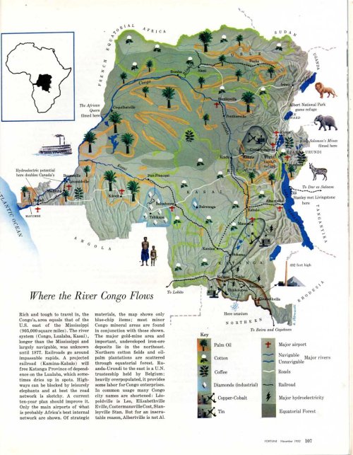
A map of the Congo River and its region, from the November 1952 issue of Fortune.

 “The Earth According to Haushofer, Geopolitician Extraordinary and Prophet of Nazi Domination” published in Fortune, November 1941. The text below this map indicates that it is azimuthal map projection, upon which Sir Halford Mackinder’s map of lebensraum (right) is transferred.
“The Mackinder map… fails to illustrate the roundness of the earth. Above is the Mackinder map on an azimuthal projection, centered near the ‘pivot area.’ This provides the ’roundness,’ but is subject to extreme distortion at the periphery… The azimuthal map also shows that the ‘outer crescent’ is not a crescent at all. Its tips meet, forming a ring – welded where? In North America.”

Finally, a cartogram of U.S. Army supply sources that accompanies an article called The Industrial Northeast” in Fortune (undated, included at Fulltable.com on this page).

Enjoyed this Jon – reminds me of some of Miguel Covarrubias’ (the Mexican caricaturist) work. here’s a sample:
http://www.americanartarchives.com/covarrubias.htm
we have a small precious collection of maps he did for the 1939 SF World’s Fair, the Golden Gate International Exposition. Beautiful.
Totally reminds me of the encyclopedias of old, when teaching geography was still in vogue… the visual-ness of landforms, or cultures or foods was always a kick of to my imagination as a 4th grader…