Archive for the ‘04 Map-Making Tools’ Category
Making Maps now at makingmaps.substack.com
Posted in 01 What's A Map?, 02 Why Are You Making Your Map?, 03 Mappable Data, 04 Map-Making Tools, 05 Geographic Framework, 06 Map Layout, 07 Hierarchies, 08 Generalization & Classification, 09 Map Symbolization, 10 Type on Maps, 11 Color on Maps, 12 Finishing Your Map, tagged Cartography, data analytics, Denis Wood, Geographic Information Systems, geospatial, information design, John Krygier, Making Maps, maps on January 17, 2025| Leave a Comment »
Book Review: Matthew Edney: Cartography. The Ideal and Its History
Posted in 01 What's A Map?, 02 Why Are You Making Your Map?, 03 Mappable Data, 04 Map-Making Tools, Deep Map Thoughts, Map Books, Map History on June 30, 2020| 1 Comment »
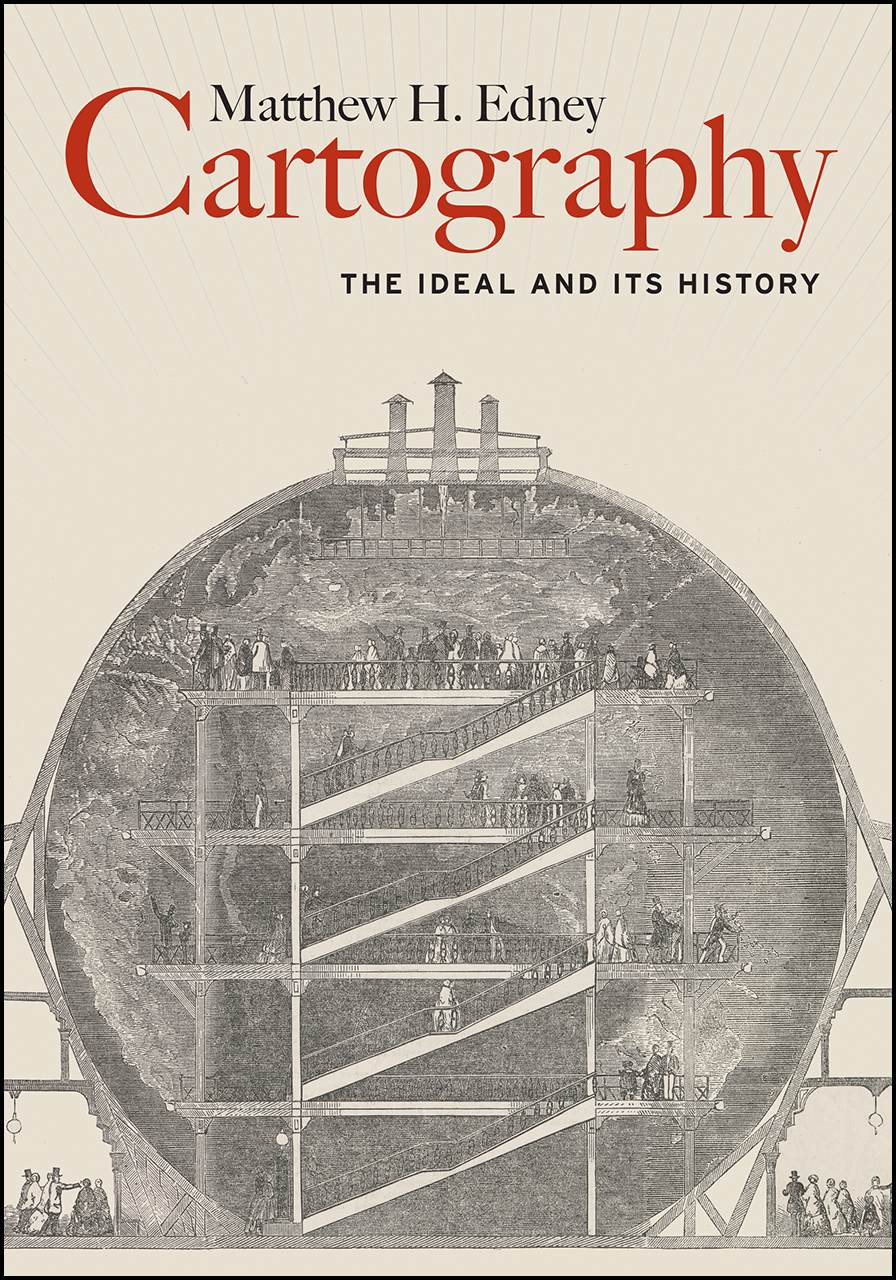
Matthew H. Edney. Cartography. The Ideal and Its History. xiii + 309 pp., figs., bibl., index. Chicago: The University of Chicago Press, 2019. $30.00 (paper), ISBN 9780226605685.
Matthew Edney @ USM
Matthew Edney @ Mapping As Process
University of Chicago Press Book Information
Book Review by John Krygier published in Isis: A Journal of the History of Science Society—Volume 111, Number 1, March 2020 (pp. 207-208)
There is no such thing as cartography, and this is a book about it. (p. 1)
Matthew Edney’s Cartography: The Ideal and its History provides a necessary corrective to the normative ideal of maps, mapping and the field of cartography. While of interest to scholars in the history of cartography, Edney’s book is just as important to the growing number of scholars whose research engages maps and mapping as part of diverse studies of culture, society and human history. Cartography: The Ideal and its History details problematic assumptions about maps, mapping and cartography, but it’s the creative potential of Edney’s book that’s most notable. As untenable assumptions are discarded, new insights emerge, insights which have the potential to greatly expand our understanding of maps and mapping across many different studies and disciplines.
Edney’s Cartography is situated in the intermingled fields of the history of cartography and critical cartography with touchstones including The History of Cartography, Book 1, edited by J.B. Harley and David Woodward (1987), Harley’s “Deconstructing the Map” (1989) and Denis Wood’s The Power of Maps (1992). These works, and many that followed, undermined narrow definitions of the map and broadened our understanding of the cultural, social and political context of mapping. Edney’s work as editor of later volumes of the History of Cartography, extensive publications on maps from Europe, North America and India as well as critical cartography make him an ideal scholar to take on the ideal of cartography. He does so by characterizing the traditional study of maps and mapping as “a profound act of cultural misdirection.” Maps and mapping are more complex, nuanced and disjunct than the universalizing, idealized conceptions offered by modern cartography, a thesis strongly supported by Edney’s immersion in diverse historical maps and mapping practices.
The most appealing parts of Cartography: The Ideal and its History are the delineation of fourteen modes of Western mapping and an intellectual assault on cartography’s idealized preconceptions. These issues are addressed in the first third of the book, prefaced by a discussion of the ideal and its limitations. Mapping modes include place, urban, property, engineering, chorographical, cosmographical, geographical, marine, celestial, boundary, geodetic, analytic, and overhead imaging. The concept of modes shifts focus away from a singular, idealized map (and map making process) to distinct (but evolving and interrelated) map types and processes that are better understood free of the narrow, idealized context within which they are typically situated. Cartography’s idealized preconceptions include ontology, pictorialness, individuality, materiality, observation, efficacy, discipline, publicity, morality and singularity & universality. In each case, Edney describes, critiques, and offers alternatives to these preconceptions. With the concept of mapping modes and critique of preconceptions in place, an intellectually sophisticated, nuanced and creative understanding of maps and mapping processes can play out.
Chapter 4, The Ideal of Cartography, details the construction of cartography as “a modern myth.” The chapter weaves in references to mapping modes and idealized preconceptions. One is left, upon finishing this chapter, with a history of the construction of modern cartography as well as an understanding of its limitations. Chapter 5 critiques the idealized geometry at the heart of modern cartography, specifically map scale. Much like maps and cartography in general, it is easy to naturalize map scale. This chapter, like the rest of the book, brings a sense of unease: many seemingly natural aspects of our common understanding of cartography are carefully constructed myths.
Cartography: The Ideal and its History is scholarly, well-written and a significant contribution to the history of science. It covers some ground explored by other recent scholars (including Matthew Wilson’s 2017 New Lines) but with a stronger footing in historical scholarship. Edney’s mapping modes and idealized preconceptions provide actionable ideas which are often lacking in critical cartography literature. It’s not clear, however, if Edney’s work will have much of an impact on modern mapping practitioners (cartography, geographic information systems, Geospatial technology) or academics in these technical fields. The myth of cartography is, if anything, functional and serves the needs of particular people and groups (property ownership, the military, government bureaucracy, business, etc.). Online mapping and navigational tools, such as Google Maps, are rife with problems (such as the inclusion of fake businesses that generate income for Google and for companies who pay to have these businesses on the map). Alas, people find such services useful and don’t really think the maps and information they engage with are anything other than an image of the real world. At the very least, scholars should not fall into the same trap: Matthew Edney’s Cartography: The Ideal and its History provides a corrective, a reimagined intellectual framework for maps and mapping that will, when engaged and operationalized, greatly broaden our understanding of the wondrous array of inscriptions and practices we call maps and mapping.
John Krygier
Professor of Geography
Ohio Wesleyan University
Delaware, OH. 43015
jbkrygier@owu.edu
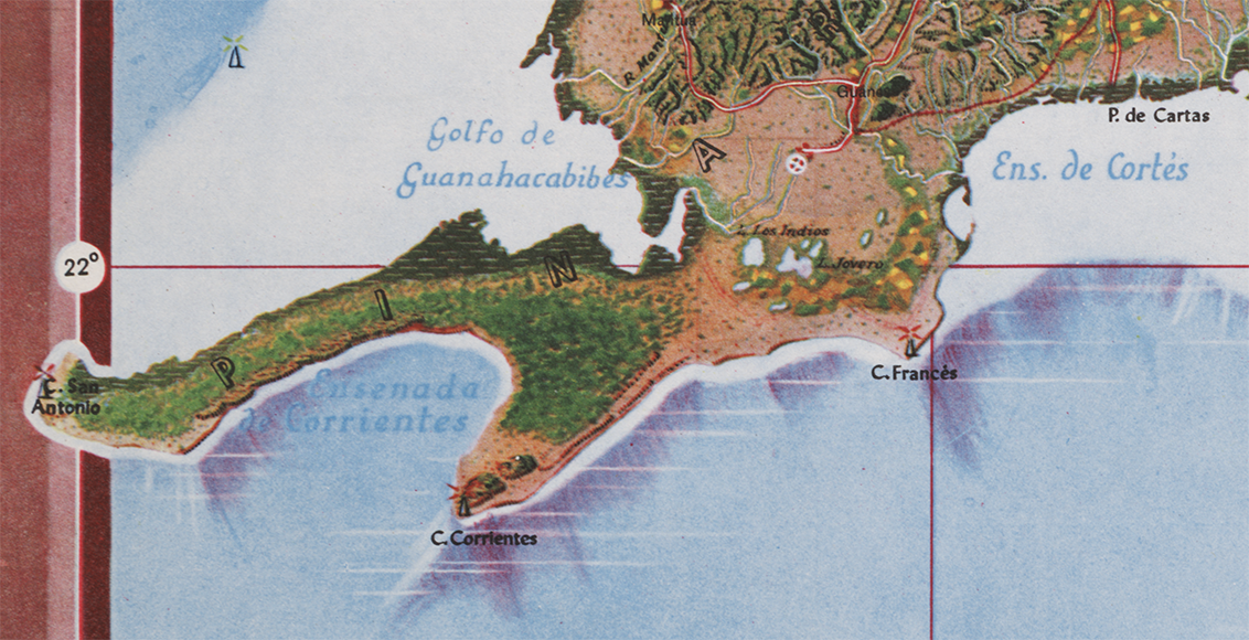
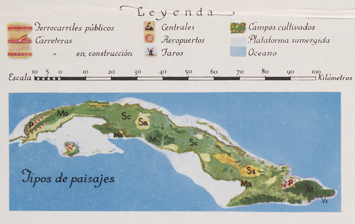
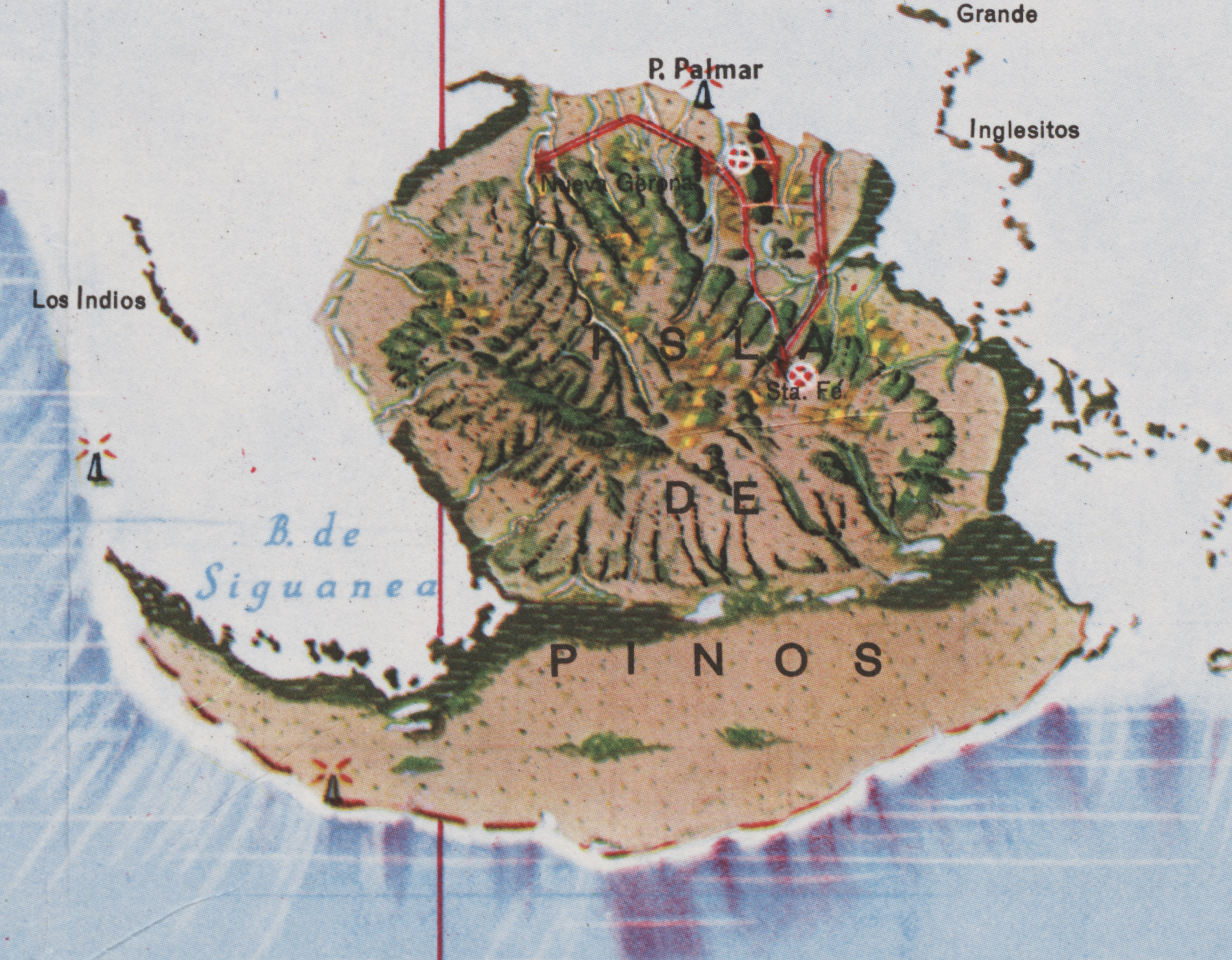
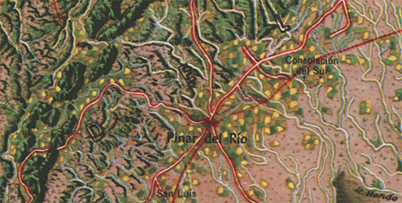
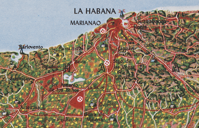
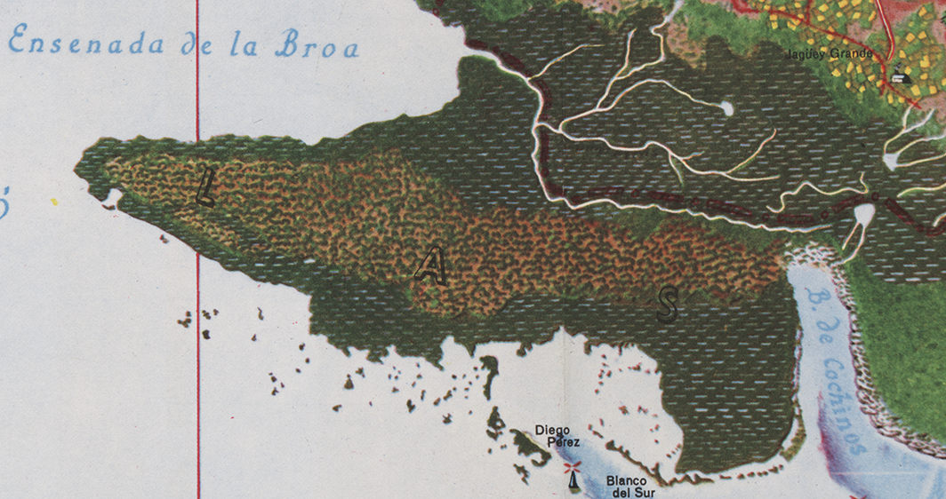
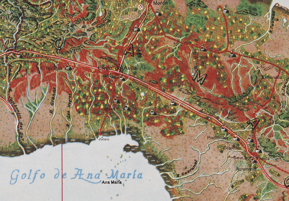
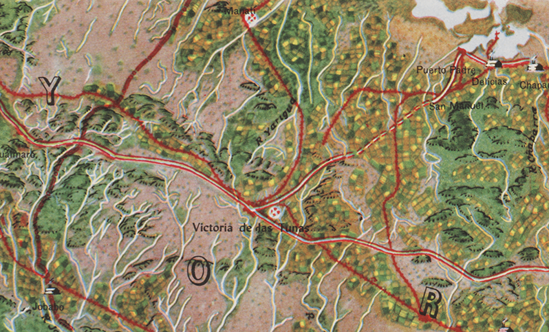
Mapa de los Paisajes de Cuba | Map of the Landscapes of Cuba | 1949 | Gerardo Canet & Erwin Raisz
Posted in 02 Why Are You Making Your Map?, 03 Mappable Data, 04 Map-Making Tools, 09 Map Symbolization, 11 Color on Maps, Map History, tagged Cuba - maps, Erwin Raisz - Atlases, Erwin Raisz - Map Design, Natural color mapping - history on July 29, 2014| 10 Comments »

The Atlas de Cuba by Gerardo Canet and Erwin Raisz, featured in a recent posting here, is accompanied by a large color map entitled Mapa de los Paisajes de Cuba (Map of the Landscapes of Cuba). The map is a hybrid of Raisz’s landform map style supplemented with diverse human landscape components. Canet and Raisz explain their methodology:
The accompanying map of Cuba is a new experiment in cartography. Color suggests land types: cultivated fields, pastures, mountains, swamps, valleys, etc. The symbols were selected after a series of flights over the Island and on analysis of numerous color photographs taken from the air It is expected that in this way the map will better reflect reality; more closely resembling on air view of the Island than the conventional maps we now have.
This approach is part of a tradition of natural or real color mapping combining terrain (in particular, shaded relief) with air imagery or map symbolization inspired by air imagery, an obvious outcome of aerial mapping in the early part of the 20th century. An article by Tom Patterson and Nathaniel Vaughn Kelso entitled Hal Shelton Revisited: Designing and Producing Natural-Color Maps with Satellite Land Cover Data (2004) delineates the author’s development of the Natural Earth data (shaded terrain + satellite land use data) in the context of earlier, related work by Hal Shelton, Eduard Imhof, Heinrich Berann, Richard Edes Harrison and Tibor Toth. It seems that Raisz was also an innovator in this realm of air-imagery inspired map design.
••••••••••••
See also, at this blog, Raisz’s History of American Cartography Timelines, Map Symbols: Landforms & Terrain, and Raisz’s currently available landform maps at www.raiszmaps.com.
••••••••••••

Mapa de los Paisajes de Cuba, 1949 (36.6mb)
••••••••••••••••••
Map details:


Map Art Exhibitions, 2012-13
Posted in 01 What's A Map?, 02 Why Are You Making Your Map?, 03 Mappable Data, 04 Map-Making Tools, 09 Map Symbolization, Deep Map Thoughts, tagged Cartography - art, Maps - art, maps - art - exhibits on May 12, 2014| 2 Comments »
Céline Boyer: Empreintes (from Céline Boyer)
•••••••
Denis Wood’s 2010 book Rethinking the Power of Maps includes a discussion of exhibits devoted to maps created by artists prior to 2010. A significant number of exhibits have opened since the book was published. Map Art Exhibitions, 2010-11 was posted in late 2012, and an update for 2012-13 is below.
Map Art Exhibitions, 2012-13
While we know there were more exhibitions than we cover here – so please note any we’ve overlooked in the comments – the last two years have marked a slackening of interest in map art as the genre is increasingly taken for granted. Map art is gradually seeping into art the way landscape painting did into the Western tradition in the fifteenth and sixteenth centuries, solidifying its position in the world of art as it loses its novelty.
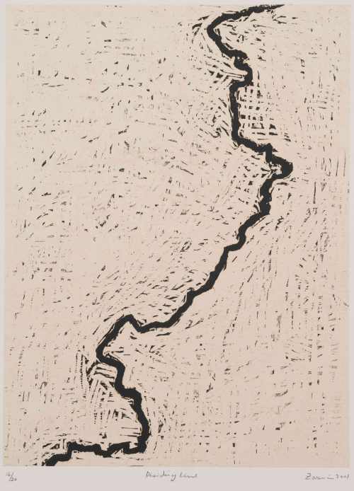
Zarina: Dividing Line (Paper Like Skin, Guggenheim)
One thing this means is that map art is beginning to show up in broader bodies of work – as in Zarina Hasmi’s (above) or Erik Parker’s (below) – and in exhibitions on other themes – as in three of shows we’ve included here.
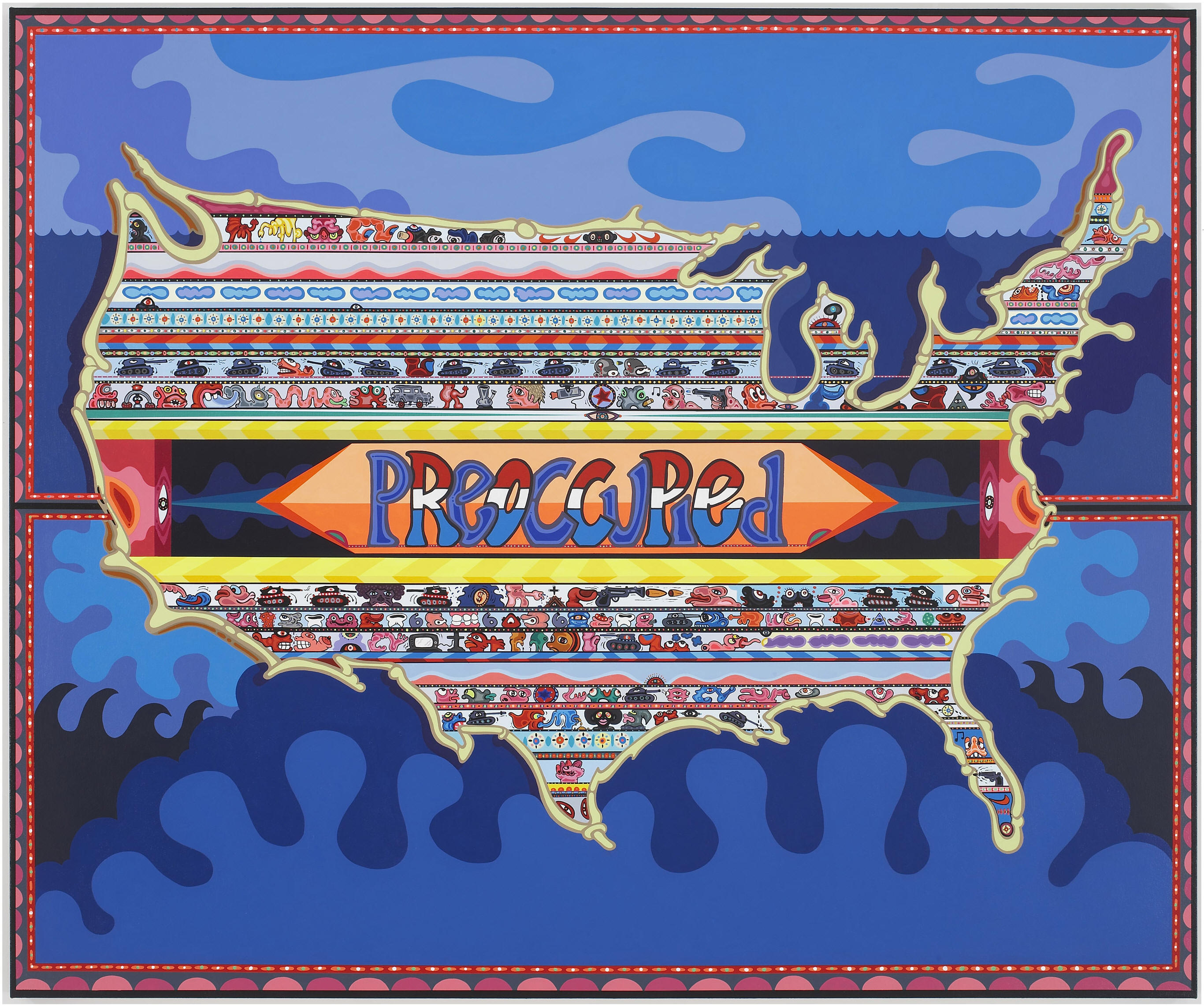
Eric Parker: Preoccupied (Too Mad to be Scared: Aldrich Contemporary Art Museum)
•••••••
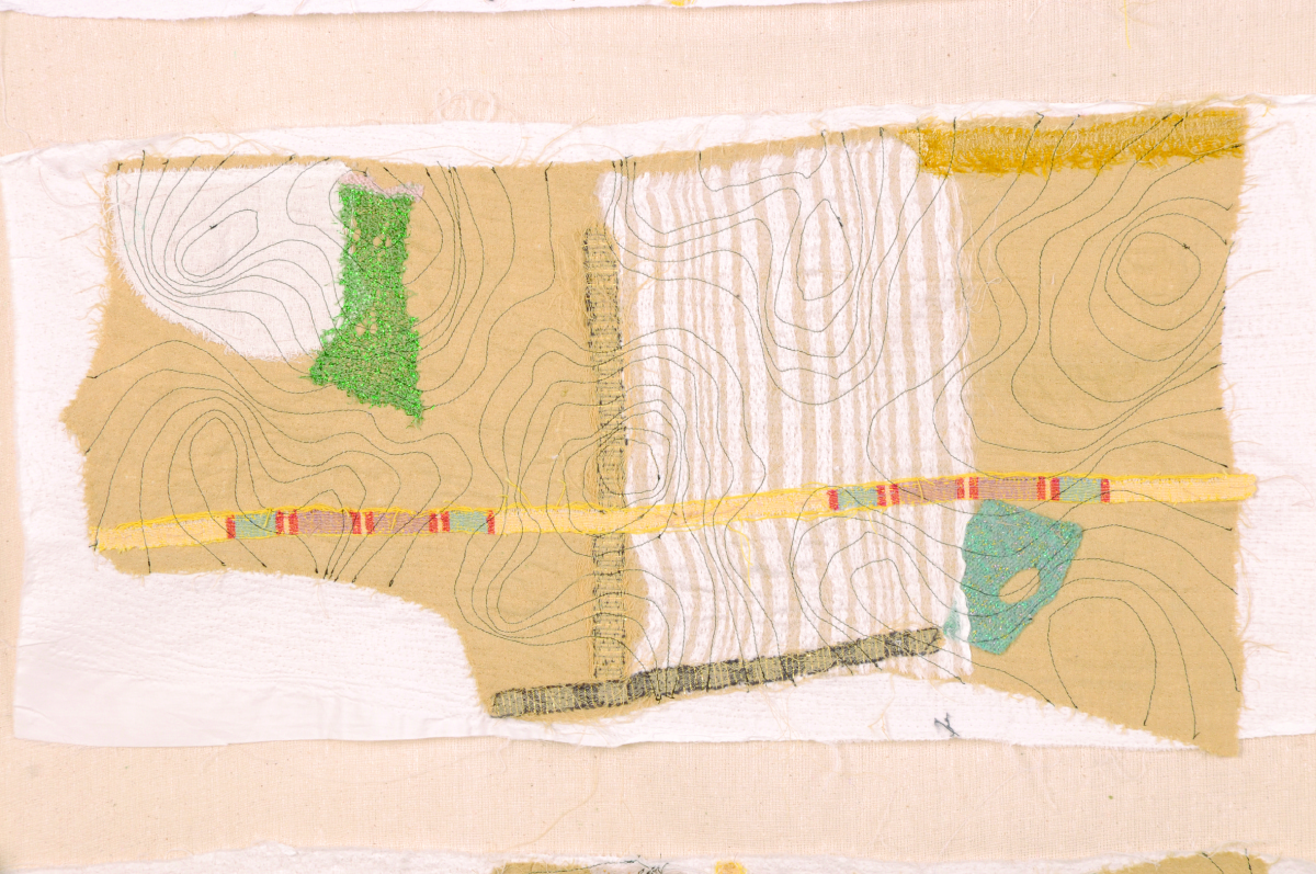
Julia Penrose: from Mapping the Future: Where Are You Now?
Mapping The Future: Where Are You Now? Textile Forum South West, Gallery at The Brewhouse Theatre & Arts Centre, Taunton, England, 2012. Following a successful Textiles Forum South West (TFSW) conference, Maps define the future: where are you now? held at Somerset College in 2011, our exhibition here included the work of 35 textile artists reflecting on a variety of map themes. The artists utilized a range of experimental techniques, including delicate hand stitch, felt making, quilting, collage knitting, sculpture as well as digital media. Reviews of the show are posted at the exhibition site, along with descriptions of all the projects. There’s a catalogue too, as well as a DVD of the show.
•••••••

Joyce Kozloff: JEEZ (Joyce Kozloff)
Joyce Kozloff: JEEZ, The Armory Show Modern, New York, 2012. About JEEZ, which hung at the main entrance of the 2012 Armory Show Modern in New York, Kozloff has said, “JEEZ is my election year piece, a 12’ x 12’ painting based on the Ebstorf map, a 13th century mappa mundi, which depicted Biblical stories and pagan myths within the world as it was then known, with Christ’s body as a symbolic and literal frame. I have inserted and rendered 125 images of Jesus from the history of art and worldwide popular culture – black, Latino, female, Asian; adults and babies; gay and straight; images from the movies and New Age hippies off the Internet – each true to its artistic ideal. As the archetypes and stereotypes accumulate, holy portraits are transformed into a rogue’s gallery of mismatched characters. Seen altogether, this proliferation wryly erodes their power.” Kozloff’s work was also included in a number of the other exhibitions noted here, in exhibitions at D. C. Moore in New York, and elsewhere.
•••••••

from Atlas Critique
Atlas critique, Parc Saint Léger, Contemporary Art Centre, Pougues-les-Eaux, France, 2012. The curators of this very interesting show wrote: “Although we are aware of the extent to which cartography as a discipline has been profoundly imbricated in the performative production of the narratives of modernity, in objective and positivist rationality, but also the history of colonialism and nationalistic constructions, for artists today, it has become a privileged site for the invention of counter-practices that open up new perspectives and participate in a deconstruction of hegemonies and post-colonial epistemologies as alternative tools for the production of knowledges, narratives and realities.” In demonstration of this they showed the work of, Francis Alÿs, Erick Beltrán, Berger & Berger, Border Art Workshop [a San Diego-based collaborative], Mark Boulos, Lewis Carroll / Henry Holiday, Chto delat? [a Russian art collective], Fernand Deligny, Michael Druks, Claire Fontaine, Internacional Errorista [an international art movement], Pedro Lasch, Vincent Meessen, Nástio Mosquito, Estefanía Peñafiel Loaiza, Lia Perjovschi, Radek Community+Dmitri Gutov [Moscow-based group], Philippe Rekacewicz, R.E.P. Group [a Ukrainian art collective], Allan Sekula & Noël Burch, Société Réaliste [a Parisian cooperative], Stalker [a walking group based in Rome], Endre Tót, David Wojnarowicz / James Wentzy / AIDS Community Television. This was an amazing exhibition, accompanied by conferences, performances, and films.
•••••••
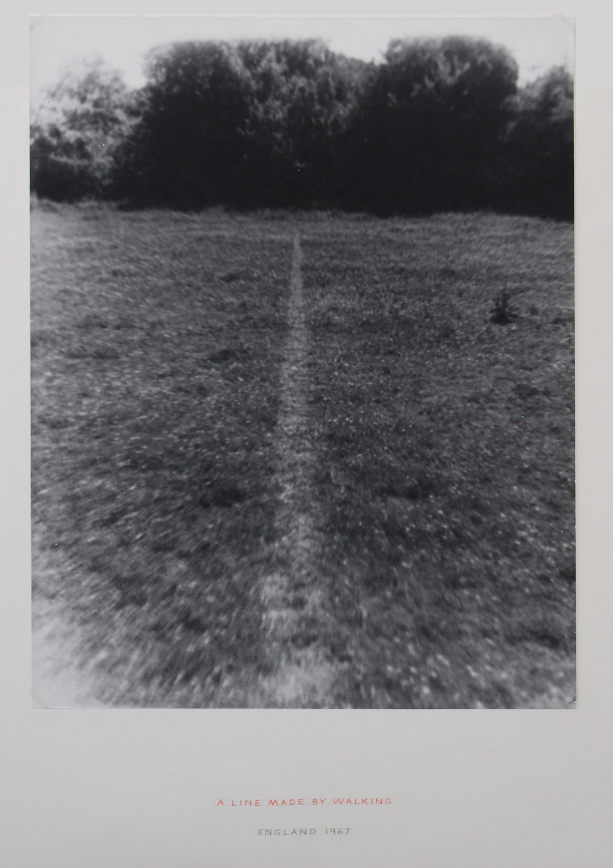
Richard Long: A Line Made by Walking (from Contemporary Cartographies: Drawing Thought)
Contemporary Cartographies: Drawing Thought, CaixaForum, Barcelona, Spain, 2012. Curated by Helena Tatay, this important exhibition included more than 140 works by 77 artists, from the classics (Dalí, Debord, Duchamp) to the contemporary (Alÿs, Kentridge, Kuitca), with the goal of “inviting the visitor to question both the systems of representation that we use and the ideas that underpin them.” As the press release put it, “The central aim of this exhibition is, therefore, to explore the ways in which contemporary artists have used cartographic language to subvert traditional systems of representation, propose new formulas or suggest the very impossibility of representing a globalised, ever more chaotic world.”
•••••••
Joyce Kozloff: Targets (from The Map as Art, Kemper Museum)
The Map as Art, Kemper Museum. St. Louis, Missouri, 2013. Inspired by Katharine Harmon’s best-selling book, The Map as Art, this exhibition presented work that explored the issue of mapping – whether conceptually or quite literally – while examining systems of personal gesture involved in large-scale works. The exhibition featured more than 30 works by seven artists: Ingrid Calame, Nathan Carter, Tiffany Chung, Joyce Kozloff, Lordy Rodriguez, Robert Walden, and Heidi Whitman, several of whom made presentations in the extensive programming that accompanied the show. It was co-curated by Kemper Museum curator Barbara O’Brien and Katharine Harmon. There was an illustrated gallery card. Sept 14, 2012-April 21, 2013.
•••••••
David Reimondo: Patch World Inverso (from MAPPAMUNDI, art et cartography)
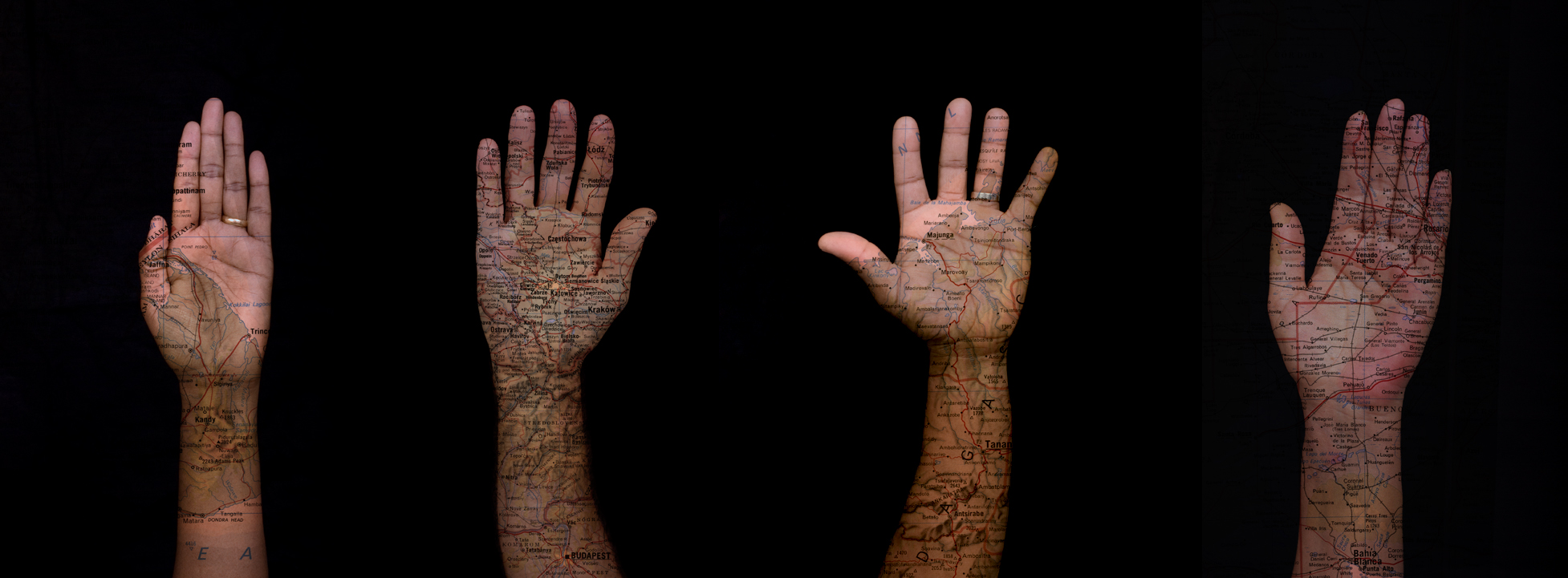
MAPPAMUNDI, art et cartographie, Hôtel des Arts, Centre d’art du Conseil général du Var, Toulon, 2013. Less pretentious than some shows, but more exciting, MAPPAMUNDI brought together 58 works by 26 artists, a number of them represented in Atlas critique (for example, Stalker) and/or Contemporary Cartographies: Drawing Thought (for example, Kuitca) in a show organized by Guillaume Monsaingeon around three themes: the body, combat, and the tale. Monsaingeon also wrote the fully-illustrated, 190-page catalogue, MAPPAMUNDI, art et cartographie, which opens with a long history of maps and map art. The exhibition included Céline Boyer’s project Empreintes, a collection of photographs of hands, against black backgrounds, on which maps of their places of origin (Senegal, Iran, Spain, and so on) have been superimposed. A 100-page book – all of which fold out – documents Empreintes. Boyer’s project is connected to those in the exhibition of Qin Ga and Kuitca, though indeed this show was rich in resonances.
•••••••

Expanded Map (from Expanded Map)
Expanded Map, RM Gallery, Auckland, New Zealand, 2013. Curated by Ruth Watson and James Wylie, who both co-authored the catalogue and have pieces in the show, Expanded Map is an artists show in an artists space. With the exception of Gigi Scaria, Lize Mogel, and Clare Noonan all the artists are locals: Auckland has a rich map art scene! The show was divided into two parts, both of them covered in the color catalogue.
•••••••
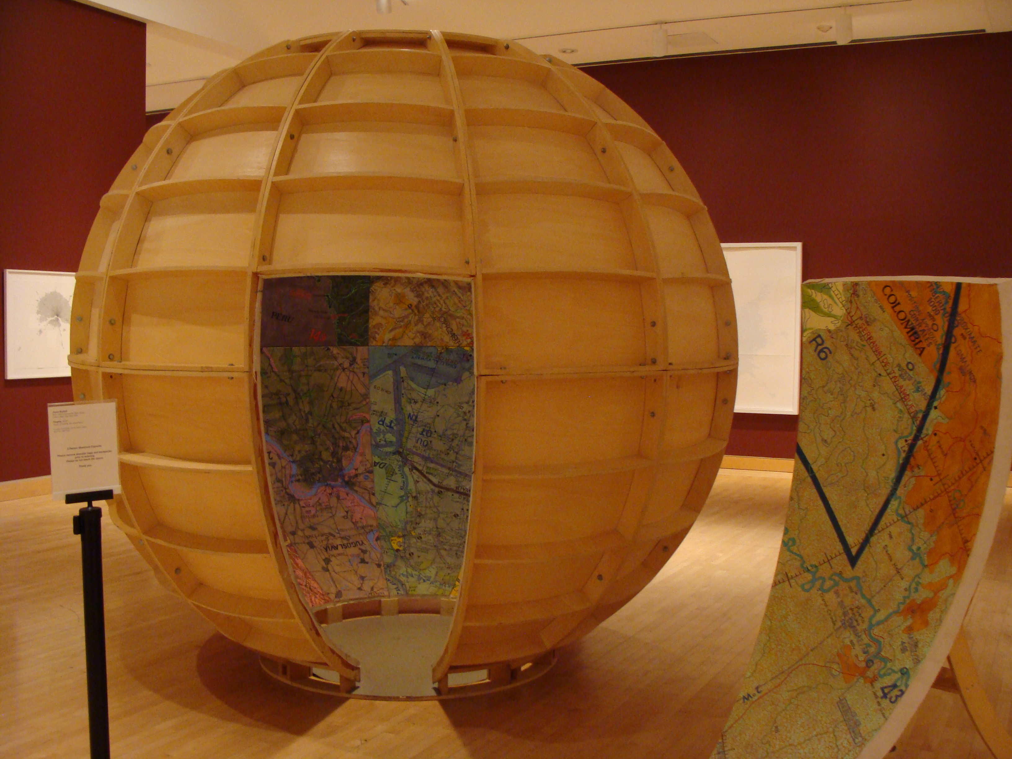
Mark Schatz: Universe Hive (From ArtHopper.com)
Universe, The Sculpture Center, Cleveland, Ohio, 2013. Mark Schatz mapped the world in this sprawling, double-sided landscape model built with ideas from architects, planners, hobbyists, and self-taught artists,. The faceted map could be folded up to make a Buckminster Fuller-inspired cuboctohedron; and it drew attention to individual perceptions of ones place, ones residence or “home,” and how it’s all a multifaceted, living, growing experience.
•••••••
Samuel Rowlett, Still From “Landscape Painting in the Expanded Field” (from Artfcity.com)
Artists’ Walks: The Persistence of Peripateticism, Dorsky Gallery, New York, 2013. Curated by Earl Miller, this is an example of a show tangential to the world of map art, but in an essential way, for walking, after all was for most of human history how we came to know the world. A lot of peripatetic art still uses maps to document the walks. Here this was the case for the work of Danica Phelps, Gwen MacGregor, and Sandra Rechico. The latter two also organized a piece, “Map It Out (New York),” in which they invited people to map the travels they’d made during the day, and then they assembled the collected drawings into a psychogeographic portrait of New York that hung alongside works by Richard Long, Hamish Fulton, and others. Neat show.
•••••••
Joseph Kosuth: From Memory, Draw a Map of the United States (from Huffington Post)
From Memory: Draw a Map of the United States, Sean Kelly Gallery, New York, 2013. This show is the first presentation of a project conceived and produced in 1971-1972 by Hisachika Takahashi. Takahashi, a Japanese artist living in New York, asked twenty-two fellow artists to each draw or paint a map of the United States entirely from memory on the handmade Japanese paper he provided: Arakawa, Jed Bark, Mel Bochner, Juan Downey, Alex Hay, Jasper Johns, Joseph Kosuth, Jeffrey Lew, Jane Logemann, Brice Marden, Gordon Matta-Clark, Richard Nonas, Robert Petersen, Robert Rauschenberg, Dorothea Rockburne, James Rosenquist, Keith Sonnier, Hisachika Takahashi, Cy Twombly, Susan Weil, Lawrence Weiner, Robert Whitman and Don Wyman. It’s a valuable document of the scene and of the map ferment beginning to grip the art world.
•••••••

Detail from Nalini Malani and Iftikhar Dadi: Bloodlines (from IndiWeek)
Lines of Control: Partition as a Productive Space, Nasher Museum of Art, Duke University, Durham, North Carolina, 2013-14. This is another show at once tangential to map art and yet concerned with an essential map element: lines of control. The lines of control in this case are mostly borders through contested areas (India/Pakistan, Israel/Palestine, Mexico/US, and so on). Green Cardamom brought together more than thirty contemporary artists (from Francis Alÿs to Muhammad Zeeshan) and a host of other contributors (including Iftikhar Dadi and Irit Rogoff) to mount a ceaselessly stimulating exhibition, first in 2012 at Cornell and then in 2013-14 at Duke. It spawned a 240-page full-color catalogue. A great stimulating show and a terrific catalogue!
•••••••
Maya Lin: Blue Lake Pass (from IndiWeek)
Surveying the Terrain, Contemporary Art Museum, Raleigh, 2013-14. While Lines of Control was up at Duke in Durham, across the Triangle in Raleigh, CAM was showing Surveying the Terrain, another show tangential to map art, yet equally concerned with an essential subject; or, as the gallery brochure put it, “Surveying the Terrain explores contemporary artworks that map our terrain.” Curated by Dan Solomon, it featured ten artists including Alfredo Jaar, Laura Kurgan, Maya Lin, and Trevor Paglen. Beautiful work!
•••••••
(from Bronx River Art)
MAPnificent! Artists Use Maps, Bronx River Art Center, New York, 2013-14. Curated by Yulia Tikhonova, this show’s 18 artists – among whom were Paula Scher and Mannahatta – approached the map from every direction. This may have been the year’s most classic map art show, a fading form.
•••••••
Roosmarijn Pallandt (from Roosmarijnpallandt.com)
Unmapping the World, EXD’13 / Instituto de Investigação Científica Tropical, Palácio dos Condes da Calheta, Lisbon, Portugal, 2013. Part of Experimental International Design Biennial 2013, and curated by Annelids de Vet (of the Subjective Atlas of … fame) and Nuno Coelho, the exhibit was “an exploration into the field of reactive map making practices. It aims to counterpoise the apparent neutrality of professional cartography through contemporary engaged mapping projects. In this exhibition, ways of mapping are used to resist the authority of state, to question ruling power structures and to expose the propensity of maps to simplify our world. The act of uncapping is presented as a poetic form of resistance.” And so much more!
•••••••

Across the Wall: Israeli Settlement Bus Routes: Ahmad Barclay & Polypod (from Visualizing Palestine)
The Cartography of the Unseen, The Research Gallery, Holon Institute of Technology, Holon, Israel, 2013. This exhibition dealt with “the political reading of the overt and covert mechanisms embedded in the act of cartography, by exposing the ideological aspects, as well as the solicitation to action performed through mapping. The exhibition analyses the ways in which the design of maps conditions the very interpretation of them, and examines how the act of mapping affects the reorganization of the mapped territory.” Thirteen projects from as many territories were presented, including work from both Israel and Palestine. Radical presentation!
•••••••
Old Map Newsreels 1935-1965: British Pathé
Posted in 02 Why Are You Making Your Map?, 03 Mappable Data, 04 Map-Making Tools, 09 Map Symbolization, Map History, tagged cartography - history, cartography - videos, Maps - History, maps - videos on April 26, 2014| 3 Comments »
The World Is Round! (1935)
••••••••••
Air Mapping (1935)
••••••••••
Moon Mapping (1953)
••••••••••
Map to the Coronation (1937)
••••••••••
Mainly Maps (1938)
••••••••••
Mapping It Out! (1940)
••••••••••
Map Depot In Desert (1943)
••••••••••
Map Making By Women’s Voluntary Service – Quite So! (1943)
••••••••••
New Maps for New Worlds (1945)
••••••••••
Mobile Map Truck (Step On It!) (1944)
••••••••••
Plastic Maps (1947)
••••••••••
Map Making (1952)
••••••••••
Interpol See Scotland Yard (Pre-Computer GIS) (1958)
••••••••••
Map Making (1961)
••••••••••
School Playground Map (1961)
••••••••••
Map Survey (1965)
••••••••••
Aerial Photography Aids Map Makers – Hungary (1965)
Linoleum Ceiling Map for Ill Supine Children | 1942
Posted in 01 What's A Map?, 02 Why Are You Making Your Map?, 04 Map-Making Tools, 09 Map Symbolization, tagged Maps - linoleum on February 5, 2014| 3 Comments »
Crippled children study map on ceiling while they lie on table taking treatments…
Innovations in linoleum maps, ca 1942:
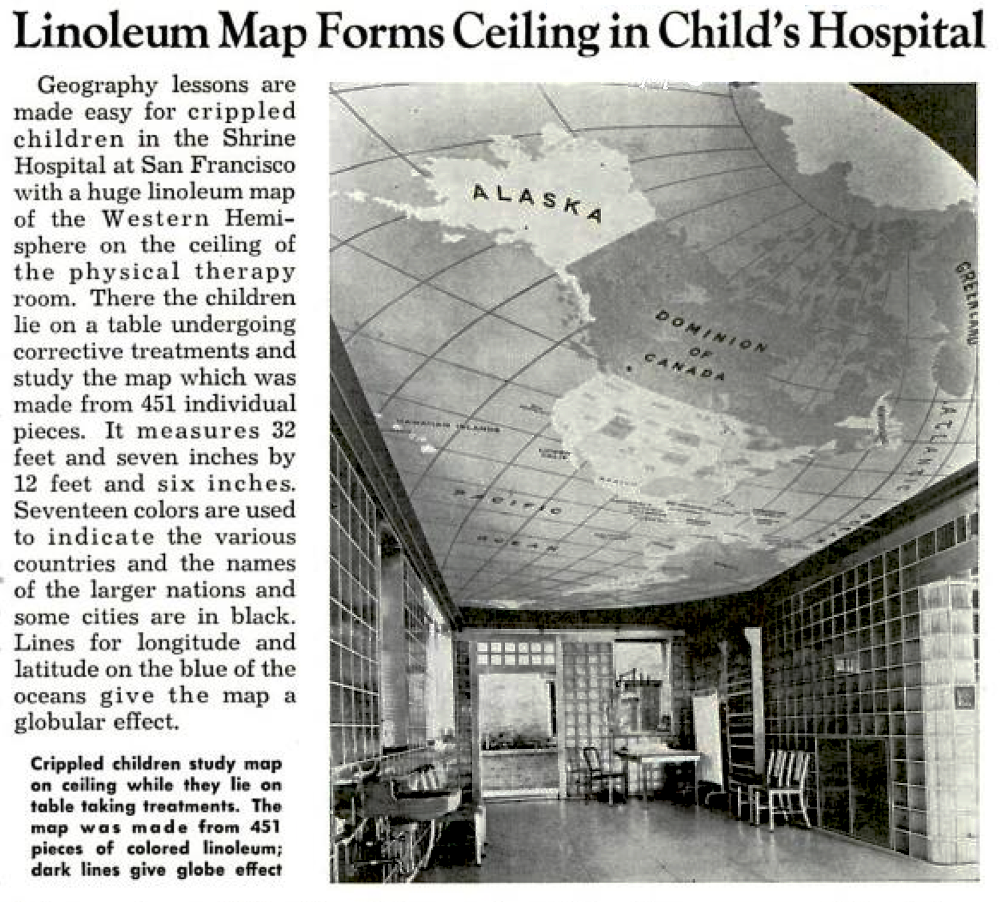
Located in the Shrine Hospital in San Francisco.
Map made from 451 individual pieces, and measures 32 feet by 12 feet.
Popular Mechanics, August 1942
Making Maps that Don’t Look Like Maps: Applied Counter-Cartocacoethes For Spies | 1915
Posted in 01 What's A Map?, 02 Why Are You Making Your Map?, 03 Mappable Data, 04 Map-Making Tools, 09 Map Symbolization, Map History, tagged Cartocacoethes, Maps - cartocacoethes, Maps - spy on July 2, 2013| 2 Comments »

Back in 2008 the word cartocacoethes was first used on this blog to describe “a mania, uncontrollable urge, compulsion or itch to see maps everywhere.”
Counter cartocacoethes can be applied in the world of espionage allowing spies to sneak intelligence out of hostile territories – making maps that don’t look like maps.
Stained-glass windows, butterfiles, leaves, moth heads…
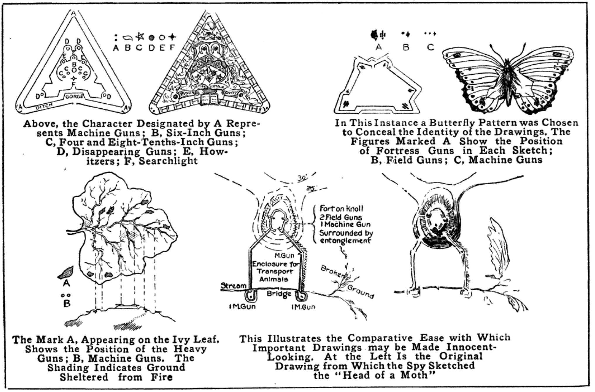
In making the drawings of fortified positions after ascertaining their plans, it was the work of the spy so to disguise them that their true character would not be recognized in the event of his capture by military authorities in the country where he was operating.
The plans of a fortification were first drawn in a regular manner and then disguised. In one case this was done by sketching ostensibly a stained-glass window. To the casual observer the drawing would bear no indication of its importance, but to the spy it was a carefully executed map of a military stronghold.
In another case the spy chose an ivy leaf as a pattern, the veins being drawn to represent the outline of the fortified position; the shading marking the ground sheltered from fire, and heavy spots, resembling worm-eaten holes, the positions of the large guns.
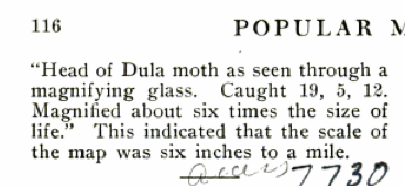
The entire article, reproduced in Popular Mechanics (July 1915) from an article in The Sketch (February 24, 1915):

Graduated Egg Map | 1931
Posted in 01 What's A Map?, 04 Map-Making Tools, 09 Map Symbolization, tagged Maps - eggs, Maps - poultry on March 20, 2013| Leave a Comment »
Iowa is dignified by the largest egg of all…
Innovations in poultry maps, 1931…
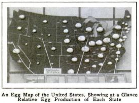
An egg map of the United States, showing at a glance relative egg production of each state, ca. 1931.
Each state is represented by imitation eggs of different sizes.
Popular Mechanics, May 1931
War Maps Made During Aeroplane Flights | 1913
Posted in 02 Why Are You Making Your Map?, 03 Mappable Data, 04 Map-Making Tools on March 8, 2013| 1 Comment »
Several signal officers flying alone or as passengers were able to make usable sketch maps of the country below them, as they flew two or three thousand feet in the air.
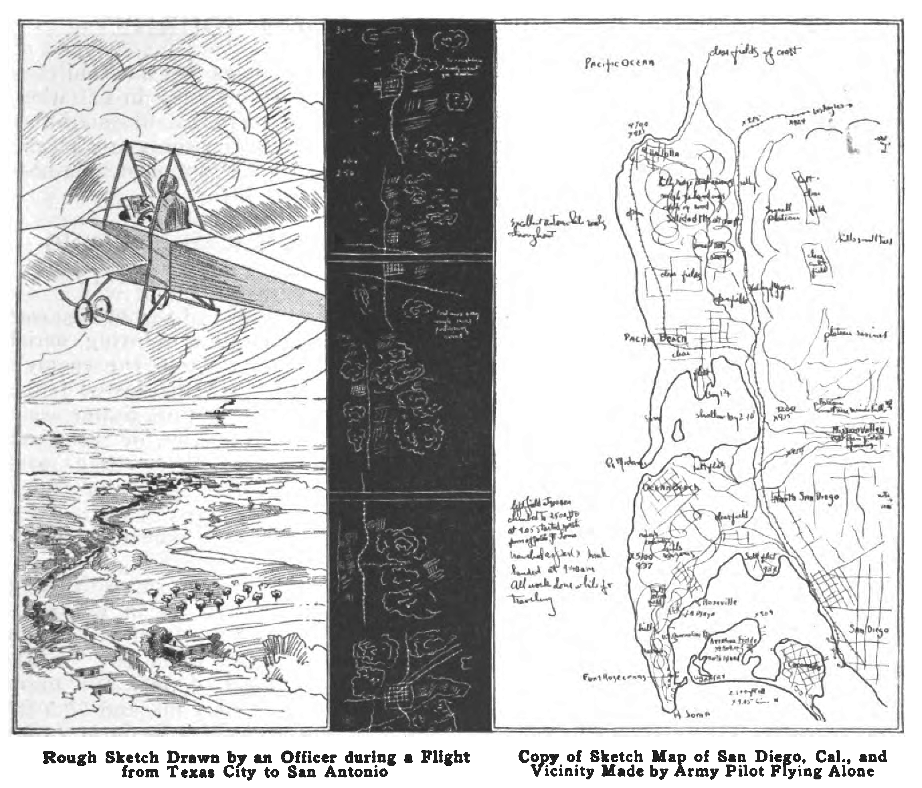
The practicability of making war maps from aeroplanes during aerial scouting expeditions into the enemy’s territory has recently been tested by the signal corps of the United States army and found entirely feasible. Several signal officers flying alone or as passengers were able to make usable sketch maps of the country below them, as they flew two or three thousand feet in the air. Two maps that were made during these tests are reproduced [above].
One of them is the rough sketch map drawn by Lieut. W.C. Sherman while riding as a passenger in an aeroplane with Lieut. Thomas DeWitt Milling on his record flight from Texas City to San Antonio. Tex., on March 28, 1913. It was drawn while they were traveling 56 miles an hour and, by means of the signal corps symbols, gives a clear picture of the country tover which they passed. Railroads, highways, streams. towns, woods. etc., are marked, and the figures on the lefthand margin indicate the aeroplane’s time. The original sketch is 12 ft. long and to scale, 6 1/2 inches equaling 10 minutes, and 1 in. equaling 1.44 mile. The other is a completed map drawn from a sketch of San Diego; Cal., and vicinity made by Lieut. J. D. Park while flying alone on May 3, 1913. a few days before his death in an aeroplane accident on May 9. The coast line and the topography of the country are indicated clearly enough to be of value to an attacking force, and at various points clear fields where airmen might make safe landings are marked out. Although the strip of country included in the map is 5 miles wide and 15 miles long, the entire sketch was made during a 35-minute flight from the aviation field at the south along the line of the railroad. At times the airman reached a height of over 3,000 ft. and from there was able to note the character of the country for 10 miles about.
Popular Mechanics Magazine, Volume 20, Number 4, October 1913.
Hand-sketched Glacial Landform Maps IV
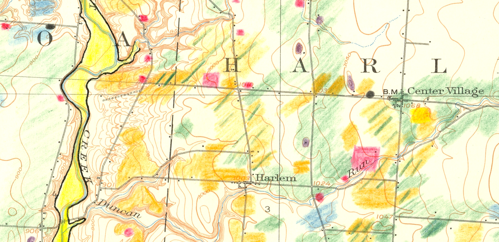
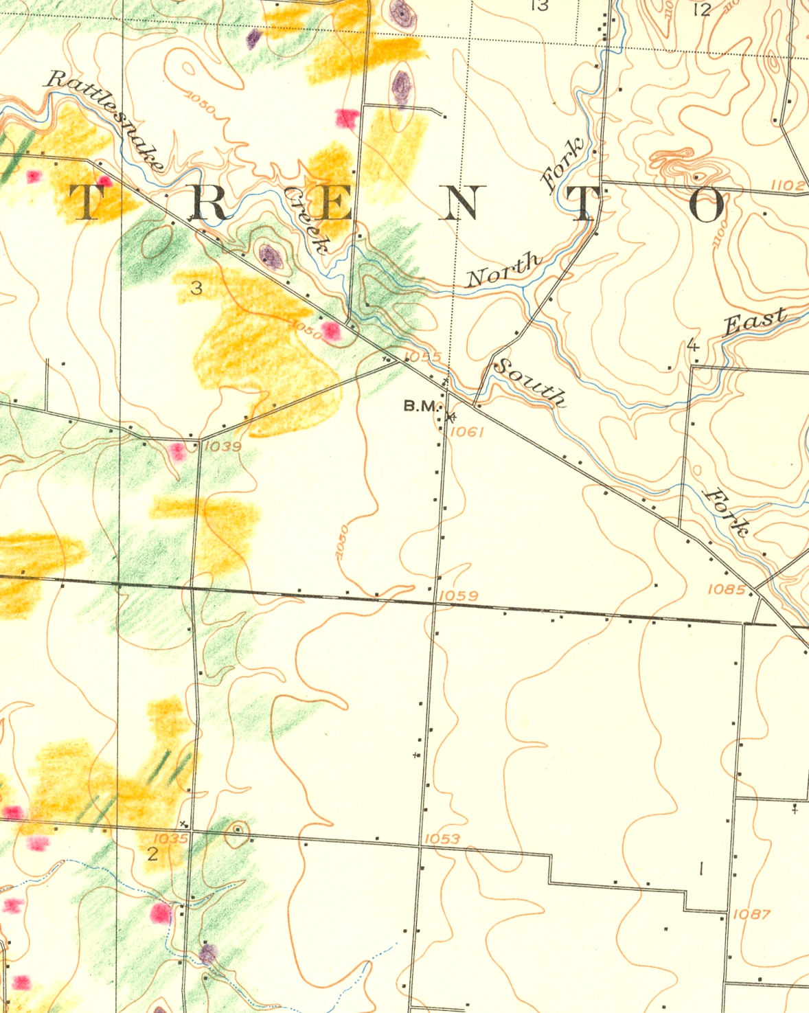
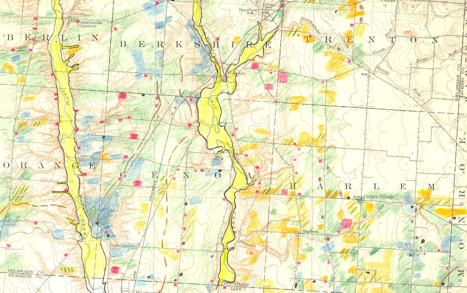
Posted in 04 Map-Making Tools, 09 Map Symbolization, 11 Color on Maps, tagged Maps - Annotated, Maps - Geomorphology on February 22, 2013| Leave a Comment »

Among the most expressive of map making tools are pencils, pens and other analog devices. The certainty of the topographic map contrasts with the precursory aesthetic of the hand drawn annotations.
This final posting in a series contains hand-sketched glacial geomorphology annotations on topographic maps by Dr. George Crowl (1910-87) who taught geology at Ohio Wesleyan University from 1947-1975. The topographic maps are from the USGS 15′ series, covering the area around Delaware, Ohio. Crowl was known for his field trips for students in Ohio and surrounding states. These manuscript maps, in the archives of the Geology & Geography Department at Ohio Wesleyan, were likely created for a generalized map of central Ohio glacial landforms for use on his field trips.
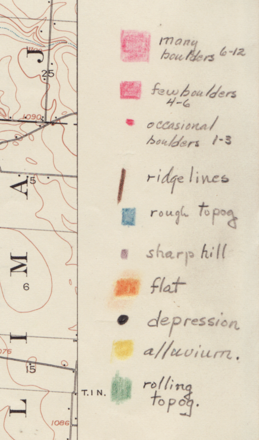
Excerpts from Westerville, OH USGS 15′ quadrangle