
Archive for the ‘05 Geographic Framework’ Category
Making Maps now at makingmaps.substack.com
Posted in 01 What's A Map?, 02 Why Are You Making Your Map?, 03 Mappable Data, 04 Map-Making Tools, 05 Geographic Framework, 06 Map Layout, 07 Hierarchies, 08 Generalization & Classification, 09 Map Symbolization, 10 Type on Maps, 11 Color on Maps, 12 Finishing Your Map, tagged Cartography, data analytics, Denis Wood, Geographic Information Systems, geospatial, information design, John Krygier, Making Maps, maps on January 17, 2025| Leave a Comment »
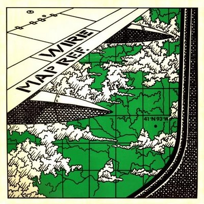
Map Songs: Wire’s Map Ref. 41° N 93° W
Posted in 05 Geographic Framework, Map Music, tagged Coordinate Systems, Graham Lewis, Latitude/Longitude, Map Songs, Wire (band) on March 11, 2008| 10 Comments »
Right on the heels of my post on the toe-tapping Longitude and Latitude song, a bit of background information on my other favorite coordinate-oriented song, Map Ref. 41° N 93° W by Wire. I quoted a bit of the lyrics from this song in the Making Maps book, to close the Geographic Framework chapter:
An unseen ruler defines with geometry
An unrulable expanse of geography
An aerial photographer over-exposed
To the cartologist’s 2D images knows
The areas where the water flowed
So petrified, the landscape grows
Straining eyes try to understand
The works, incessantly in hand
The carving and paring of the land
The quarter square, the graph divides
Beneath the rule a country hidesInterrupting my train of thought
Lines of longitude and latitude
Define and refine my altitude
A email query about the song was answered by Graham Lewis (here, here),Wire’s vocalist/bassist:
In 1978 Wire made their debut in the USA playing at CBGBs in NYC for 5 nights. When this engagement was completed I flew to LA to meet my girlfriend of the time and have 2 weeks vacation staying with friends. At the end of this I flew back to New York to hangout.
On the return daytime flight the visibility was perfect and I experienced a stunning aerial view of the Rockies and the vast Mid-Western plains…this was the inspiration for the first part of the text. I studied Geography at both O & A level and developed a fascination for maps and their reading… On this occasion one was able to read the epic landscape…vast gorges, an incomparable 2D flatness, meandering rivers, levees, oxbow lakes etc….with an unrelenting gridded road system imposed on top).
Some months later I had a similar sensation whilst traveling by road through the reclaimed agricultural lands of Holland. Whilst in the US it had been the road system here it was a grid system of drainage dikes. The vast green/ glass houses also made a memorable impression sparkling in the autumn sun….”Crystal palaces for floral kings”
The two pieces of writing dovetailed to produce one text on 2 locations…the title was conceptual… notionally the very centre of the Mid-west…I guessed and found a place called Centreville nearby… this seemed appropriate, poetical yet hardly scientific!
I knew a geographer had to have written the song.
Map Ref. 41°N 93°W was Wire’s sixth single, taken from their third album (one of my favorite albums of all time), 154.
The cover for the single opens this post.
Other album covers with maps here.
Map Songs: Longitude and Latitude Song
Posted in 05 Geographic Framework, 13 Multimedia Mapping, Map Music, tagged Cartography, latitude, longitude, Map Music, maps, Singing Science on February 27, 2008| 8 Comments »
Maps and cartography are not particularly popular as song themes.
But there is the Longitude and Latitude Song (MP3 file here). Careful or you’ll be singing this one out loud in your cubicle.
Performed by Tom Glazer and Dottie Evans, and written by Hy Zaret, the song is one of a series of sciency tunes, aimed to inspire Sputnik-era kiddies, on the Space Songs album, recorded in 1959.
Jeff Poskanzer’s terrific Singing Science web page has all the tracks from Space Songs, as well as the tracks from subsequent albums Energy and Motion Songs (“Ultraviolet and Infrared”), Experiment Songs (“We Know the Air is There”), Weather Songs (“The Water Cycle Song”), Nature Songs (“Song of the Rocks”), and More Nature Songs (“What is an Animal”).
Absent from the albums are other potential map songs: “Which Datum Do You Use?” “Project Me,” “The Large Scale/Small Scale Polka,” “Your Love is like a Decorative Font,” “She’s Natural Breaks, I’m Quantiles,” and “The Symbols of my Love are Abstract Shapes in a Selection of Different Hues Corresponding to Qualitative Data Variation.” I’ll stop now.
A quick search of a few open-source music databases (FreeDB and MusicBrainz) results in hundreds of songs with map in the title. Not many latitude/longitude songs, though. There are also quite a few mappy band names: The Maps, Swell Maps, Maps and Diagrams, Maps of the Heart (blah!), Maps and Atlases, Relief Maps, The Plat Maps, Map, Map of Wyoming, Map of the World, Town Map, The Map, Map of Africa, Map of Hell, Penguin Map Mijinko, The Search Map, Book of Maps, Minus a Map, Map the Growth, Map of July, Days without Maps, Mind Maps, Maps of Norway, and Not on the Map.
The potentially evil, formerly-open-source music database Gracenote has a moderately interesting Music Maps page, which uses recent CD lookup data to map the geography of popular music.
And, of course, the excellent World Beat Music map of the world over at Strange Maps.
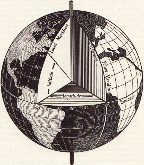
Latitude/longitude graphic from David Greenhood’s classic book Mapping.
Making Flat Earth Globes
Posted in 02 Why Are You Making Your Map?, 05 Geographic Framework, Maps Made, unMaking Maps on September 19, 2007| 41 Comments »
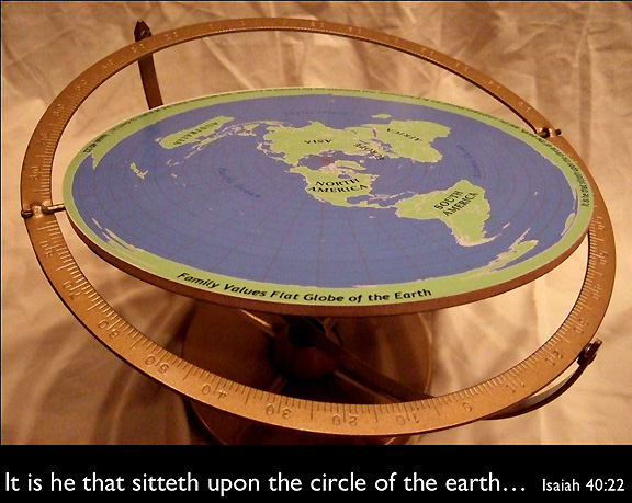
What if the world was spherical, but it didn’t matter?
Most of you have been unable to avoid the flat-earth kerfuffle on the day-time talk show The View.
On a recent episode one of the hosts, Sherri Shepherd, said she doesn’t believe the theory of evolution. Whoopi Goldberg, also a host, asked Shepherd “Is the world flat?”
Shepherd’s response was “…I Don’t know. I… I never thought about it, Whoopi. Is the world flat? I never thought about it.”
Most maps show the earth as flat. Map projection is the process whereby the surface of the 3D earth is transformed into 2 dimensions. A flat earth is usually more useful than a spherical one.
Awhile back I made a flat-earth globe for folks like Ms. Shepherd. It is a globe designed for niche cosmologies.
More images and basic instructions for making your own flat-earth globe below.
These Maps Tell Lies!
Posted in 05 Geographic Framework, 08 Generalization & Classification, Map History on July 12, 2007| 1 Comment »
I was catching up on back issues of the magazine The Independent (the May 22, 1920 issue) and came across this historical tidbit entitled “These Maps Tell Lies.”
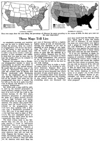
“An absolutely accurate and truthful map can be used in skillful hands to mislead the unwary. Only the crudest propagandists will distort his facts; it is far better to take the facts as nature gives them and present them in such a way to convey a false impression.”
