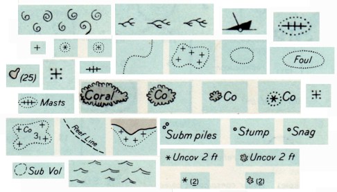
Rock which does not cover,
Coral reef, detached,
Wreck always partially submerged.
A number of sunken wrecks,
Obstruction of any kind,
Limiting danger line.
Foul ground, discolored water,
Position doubtful,
Existence doubtful.
Old map symbols and their descriptions can be poetic, enjoyable to view and read while providing ideas for symbols on contemporary maps. Indeed, is it possible that “maps are poems and poems are maps?” (see Howard Veregin’s “Geo-Poesy.”
Good map designers and map makers always look at other maps, including old maps, for map design ideas.
These symbols and textual descriptions of nautical dangers are taken from section O of Chart #1, Nautical chart symbols and abbreviations used by U.S. Lake Survey, Corps of Engineers, U.S. Army, Dept. of Defense; U.S. Coast and Geodetic Survey, Dept. of Commerce; U.S. Navy Hydrographic Office, Dept. of Defense (Washington DC, 1957). The entire page O from which the symbols were taken is here. A contemporary version of these symbols, still Chart #1, is here.

Great help, good find on the internet – thanks
Looking for a full set of Nautical Map Symbols. Especially those used by Admiralty Charts.
Thanks,
Ken
I fixed the last link in the post (after “Chart #1”) to take you to the current location of a free PDF of the book “Nautical Chart Symbols, Abbreviations and Terms” – which I think is what you are looking for.
Hi John,
I have received your email, regarding my looking for Nautical Map Symbols. The corrected link worked Great! This is exactly what I was looking for. I needed this for Dynamic Positioning.
Thank you,
Ken
Hello John Krygier. I want to extract the two symbols for “stranded wreck” and “dangerous wreck” for an article in next Riviera Reporter about a 49m motoryacht on the rocks for last 3 weeks here. But can’t isolate these symbols fromthe whole panel. Can you please advise?
How are you going to use the symbols? In other words – what kind of digital file do you need?
And also tell me the numbers of the two symbols on this page:
Click to access NauticalChart1957_Dangers.pdf
jk
Numbers 11 and 14. A Word file probably best as my copy will be in that. But maybe by pdf as well. Very grateful for your attention. Misprint in my post – yacht PARI is 40 metres; not 49m. Still rather tragic though no casualties – just dragged onto rocks in front of the D
Numbers 11 and 14. A Word file probably best as my copy will be in that. But maybe by pdf as well. Very grateful for your attention. Misprint in my post – yacht PARI is 40 metres; not 49m. Still rather tragic though no casualties – just dragged onto rocks in front of the David Niven villa when wind blew up at 04h30. Poor seamanship. MH.
The Geo-Poesy link is not available any more.
Any ideas of where I could find it?
Thank you in advance.
I put a PDF of the article up, the link should work now.
These symbols are fantastic – I’ve been looking at them with my Son (who’s just old enough to begin to enjoy map making). They certainly are poetry!
Mr. Krygier, the Coral reef, detached symbol “coral branch” is similar to petroglyphs that i have been examining. Is the reef rock symbol based on an earlyer example / time period?
Dan
Hello,
I am looking for wreck symbols on British Maps during their tenure in India. I have the maps, but they have used a variety of symbols, making it hard for me to decode them. I am looking for help, would be great if you could help.
Tiya Chatterji
Contact Matthew Edney at Univ. of Southern Maine: https://usm.maine.edu/directories/people/matthew-edney/
Hello John,
Thank you so much for your prompt response. Much appreciated.
Regards,
Tiya Chatterji