Harvard’s Erwin Raisz (1893-1968) was one of the 20th century’s preeminent cartographers (bio, bio, bio). Most people know of his landform maps, which are still in print. Raisz was also responsible for a series of atlases and hundreds of maps in books and academic articles.
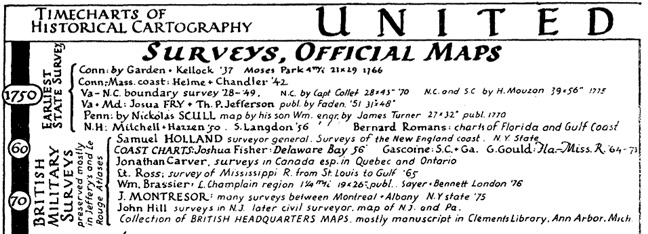
In a 1937 article for the journal Isis entitled “Outline of the History of American Cartography” Raisz generated a pair of “timecharts of historical cartography” covering key events and individuals in American cartographic history, subdivided into official maps/surveys and private cartography.
Excerpts of the charts, for educational purposes, are linked below.
The pair of charts are done up in Raisz’s unique hand-drawn style. Given their age, certain details may no longer be correct, but they capture the general sweep of American map history. The citation to the article from which these excerpts were drawn is: Erwin Raisz, “Outline of the History of American Cartography,” Isis, Vol. 26, No. 2. (Mar., 1937), pp. 373-391.

[…] Erwin Raisz is among the most creative cartographers of the 20th century, known in particular for his maps of landforms. […]
INSPIRATIONAL!