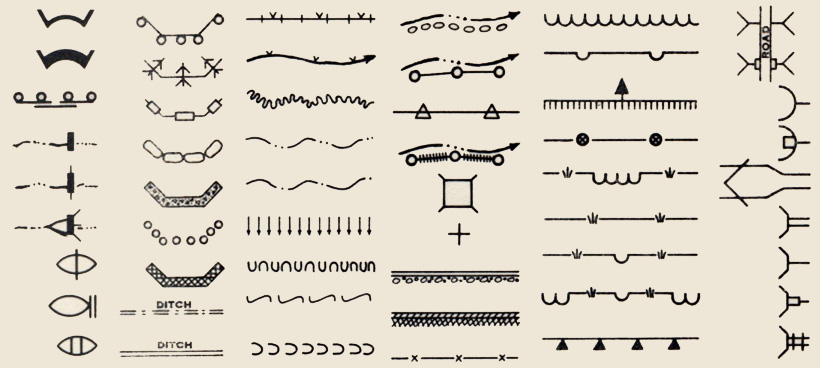
Dams, bulkheads, arches, ditches, flumes, outlet spreaders, outlet baffles, revetments, riprap, fence, gullies, borings, test pits, siphons, retaining walls, culverts, inlet transitions, jump structure, overfall, tree plantings, sheet erosion plantings, streams, lakes, terraces, ground water, water seepage, water limits, drains, percolators … the language of erosion and flood control in 1930s America.
The above symbols are selected from five pages (full PDF below) in Symbols and Instructions for Maps and Plans, a book compiled and published by the U.S. Department of the Interior Office of Indian Affairs in 1941.
Significant federally funded mapping took place in 1930s depression-era America. Different agencies compiled map standards, including map symbols, and many of these standards were published as government documents. Symbols and Instructions for Maps and Plans compiled standards and symbols from many of these sources, including the U.S. Forest Service, Soil Conservation Service, U.S. Geological Survey, National Park Service, Bureau of Reclamation, Federal Board of Surveys and Maps, and National Resources Committee, making it one of the most comprehensive of such map symbolization standards published.
The five pages of Symbols and Instructions for Maps and Plans linked below includes symbols for 28 different kinds of dams, 10 kinds of terraces 7 kinds of ditches, 7 kinds of gullies, 6 kinds of reventments, and dozens of other erosion and flood related phenomena.
Pages B-1.1 to B-1.5: Erosion and Flood Control Map Symbols (2.4 mb PDF)
Symbols can be found as pages B-1.1 to B-1.5 in Symbols and instructions for maps and plans, entire document, via HathiTrust.

I am doing an art piece on the St. Croix River and am looking for symbols relating to rivers. Where can I find these?
Try searching “river” at http://www.maphistory.info/
There may be a article on historical river symbols in one of the History of Cartography volumes (Harley, Woodward).
You may also want to try asking on the MAPHIST email discussion group.
The link to the pdf no longer works.
Changed the link. Sorry it took so long.