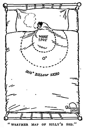
Deane Powell | Life | December 1, 1910
Posted in 01 What's A Map?, 03 Mappable Data, Map Cartoons, Map History, tagged Cartoons, maps, Weather Maps on January 22, 2008| 5 Comments »
Posted in 09 Map Symbolization, Map History, tagged coastlines, map symbols, nautical maps on January 17, 2008| 1 Comment »
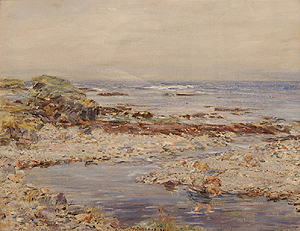
Ah, the shingly shore…
William McTaggart, A Shingly Shore, oil on canvas, 1904.
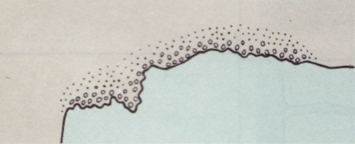
The nature of the coast: steep, flat, cliffy, rocky, sandhills, stony, shingly, sandy, mangrove, mud, gravel, coral, breakers, rubble, unsurveyed.
The nautical chart map symbol for a shingly shore is taken from section A of Chart #1, Nautical chart symbols and abbreviations used by U.S. Lake Survey, Corps of Engineers, U.S. Army, Dept. of Defense; U.S. Coast and Geodetic Survey, Dept. of Commerce; U.S. Navy Hydrographic Office, Dept. of Defense (Washington DC, 1957). The entire page A with the rest of the symbols is here (1.2 mb jpg). A contemporary version of these symbols, still Chart #1, is here.
Posted in 02 Why Are You Making Your Map?, 03 Mappable Data, 09 Map Symbolization, Maps Made, tagged maps, narrative, place, psychogeography on January 10, 2008| 31 Comments »
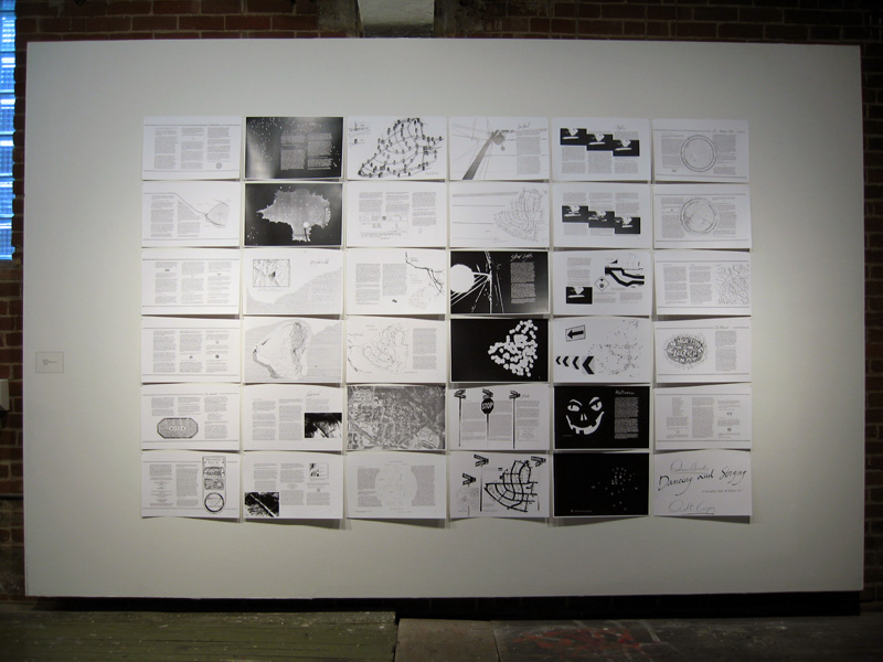
Denis Wood, co-author of Making Maps, has been working on an atlas of the Boylan Heights neighborhood in Raleigh, North Carolina since the mid 1970s. The atlas, which has never been published in its entirety, is called Dancing and Singing: A Narrative Atlas of Boylan Heights.
Inspired by Bill Bunge’s radical cartography in the 1960s and 1970s, the atlas contains diverse examples of creative, place-inspired maps, including maps of night, crime, fences, graffiti, textures, autumn leaves, routes, the underground, lines overhead, stars, and jack-o-lanterns. The atlas is of particular interest to those engaged in planning, urban history, urban geography, landscape architecture, participatory mapping and GIS, subversive cartography, counter-mapping, and psychogeography. Or anyone who enjoys creative mapping.
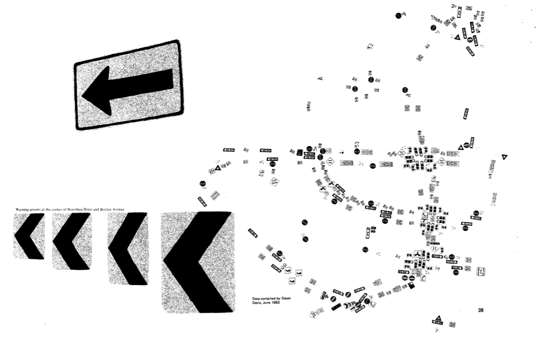
Sign Map (736kb PDF here)
The Atlas has been featured on NPR’s This American Life and in Katharine Harmon’s book You Are Here. All or or parts of the atlas have been shown at The Brattleboro Museum and Art Center, Brattleboro, Vermont (1989), the Tang Teaching Museum at Skidmore College in Saratoga Springs, New York (2001), at SCI-Arc in Los Angeles (2002), at Colby-Sawyer College in New London, New Hampshire (2002), at designbox in Raleigh, North Carolina (2004), and Publico Galleries in Cincinnatti, Ohio (2007). The image which opens this entry was taken at the Publico Gallery.
A description of the atlas by Denis and more of it’s maps follow.
Posted in 01 What's A Map?, 02 Why Are You Making Your Map?, Deep Map Thoughts on January 3, 2008| 4 Comments »
What are subversive cartographies? This issue is addressed a series of presentations organized by Chris Perkins (University of Manchester) and Jörn Seemann (Louisiana State University) for the upcoming 2008 Association of American Geographers meeting (Boston, April 15-19 2008).
“To be subversive, is to wish to overthrow, destroy or undermine the principles of established orders. As such subversive cartographies offer alternative representations to established social and political norms. Maps are no longer cast as mirrors of reality, instead they are increasingly conceived as diverse ways of thinking, perceiving and representing space and place which express values, world-views and emotions. Maps are no longer part of an elite discourse: they can empower, mystify, and enchant. More critical assessments of mapping increasingly explore subversive contexts strongly associated with innovative methodological approaches, with mapping seen as an explicitly situated form of knowledge. This shift has been strongly facilitated by the increasing popularity of new media, burgeoning technological change and newly developing mapping spaces (eg OpenStreetMap, WorldMapper and EmotionMap). So subversive mapping has an agency, which can be enacted outside existing cartographic conventions. It has escaped from the grasp of cartographers: everybody is mapping nowadays.” (edited from the original call for papers)
••••
Subversive Cartographies 1: Papers emphasizing the role of the aesthetic in the construction of alternative and artistic mappings. Common themes are the relations between artistic practice and mapping, narrative and (e)motional cartographies, and the politics of design.
Deconstructing Intentionally Manipulative Maps (IMMs)
Ian Muehlenhaus, University of Minnesota
Radical Cartography: Artists Making Activist Maps
Lize Mogel, Interdisciplinary Artist
Decolonizing Historical Cartography Through Narrative: Champlain’s Voyages Revisited
Margaret Wickens Pearce, Ohio University and Michael Hermann, University of Maine
Lynch Debord
Denis Wood, Independent Scholar
Discussant: Vincent J. Del Casino, California State University Long Beach
••••
Subversive Cartographies 2: Papers focus on the role of technologies and methodologies important in community engagement. Common themes include changing roles of the web, the emancipatory potential of GIS and ways of evaluating the aesthetic.
Subverting Civilization: Re-Mapping World History
Mellina Patterson and Stephen Hanna, University of Mary Washington
Small Voices Magnified: Using Web 2.0 for Mapping Alternative Australian Viewpoints
William Cartwright, RMIT University
Children with Physical Disabilities Map Neighbourhood Accessibility: Methodological Approaches
P. McKeever, and S. Ruddick, University of Toronto
“There is no community in Eastside”: GPS Tracks, Walking Interviews and Stories of Place
Phil Jones, University of Birmingham and James Evans, University of Manchester
Re-focusing on the Visual Politics and Practices of Grassroots GIS: Considering Subversive Potential and Limits
Sarah Elwood, University of Washington
••••
Subversive Cartographies 3: This final session focuses on more abstract aspects of subversion. Common themes include the ambiguities of the subversive, different ways of theorizing the medium and the practical, political and affectual potential of oppositional mapping.
Are Maps Autistic?
J.B. Krygier, Ohio Wesleyan University
“They have Stolen our Amazonia”: Internet Information Flows, Map Hoaxes and Nationalistic Sentiments in Brazil
Jörn Seemann, Louisiana State University
Subverting Carolina Blue: Mapping UNC-Chapel Hill through Drifting and DisOrientation
Craig Dalton, Counter Cartographies Collective UNC Chapel Hill
The Emotional Life of Maps and Other Visual Geographies
Jim Craine, California State University, Northridge and Stuart Aitken, San Diego State University
Discussant: Chris Perkins, University of Manchester
••••
Abstracts for Subversive Cartographies Presentations Below: