
Holy crap!
What to do when one of the few iconic prehistoric maps isn’t a map?
The 6200 BC “map” of Çatalhöyük in Turkey, complete with erupting “volcano” in the background, prefaces many discussions of maps and mapping. It is used to situate contemporary mapping as part of a long trajectory – “humans have always made maps.”
Alas, an important characteristic of any prehistoric “map” is that we can only speculate as to the intent of the creator. Yes we can look at some squiggly lines and say “hey, that looks like a map” but, of course, that depends on a modern sense of what a map is. And, possibly, a tendency for us to see maps where there are none.
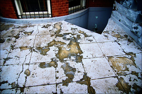
Indeed, many prehistoric “maps” may be the result of cartocacoethes – a mania, uncontrollable urge, compulsion or itch to see maps everywhere. Map simulacra like chipped paint:  a stone China:
  a mud puddle Australia:
  and “geographic tongue:”
  – a medical condition that “looks like a map.”
See also the many prehistoric squiggles (below left) illustrated in Catherine Delano Smith’s “Cartography in the Prehistoric Period in the Old World” in Brian Harley and David Woodward’s The History of Cartography, Volume One (Chicago, 1987, pp. 54-101).
 Part of me really wants these marks chipped in stone to be maps. But there does not seem to be much, if any, evidence that they are.
Why do we want mapping to stretch back into prehistory? If maps didn’t exist in prehistory, and were scarce prior to 1500, does that somehow undermine the importance of contemporary maps and mapping? What drives this cartocacoethes?
The Çatalhöyük “map” provides a great case study of the perils of prehistoric map hunting.

The Çatalhöyük map was first brought to attention in a 1964 article entitled “Excavations at Çatal Hüyük, 1963, Third Preliminary Report” by James Mellaart (Anatolian Studies 14 (1964, pp. 39-119).
A map of the excavations (right) shows the area allegedly represented on the “map.”
Mellaart’s 1967 book Çatal Hüyük: A Neolithic Town in Anatolia claimed that the Neolithic Anatolians at Çatalhöyük created the World’s first map, and fame for the map followed.
“The oldest town plan in existence” says Jeremy Harwood in To the Ends of the Earth: 100 Maps that Changed the World. “The oldest authenticated map in the world” says J.B. Harley in the UNESCO Courier. Of maps, it is, says Catherine Delano Smith in Imago Mundi, “the oldest known.” “The Catal Huyuk map … is perhaps 2000 years older than the oldest known writing system and 4000 or more years older than the oldest known alphabetical writing system…” says James Blaut in Transactions of the Institute of British Geographers. Heck, I even towed the party line in my introductory maps course lecture on the history of mapping.
Whoa, folks.
Archaeologist Stephanie Meece recently published an article in Anatolian Studies questioning the Çatalhöyük map’s status as a map. The original “map” wall painting is shown below, in a photo from Mellaart’s 1964 article. Most people have only seen the redrawing of the “map” with “volcano” (above) – not the original image.

In her article “A Bird’s Eye View – Of A Leopard’s Spots: The Çatalhöyük ‘Map’ and the Development of Cartographic Representation in Prehistory” (Anatolian Studies 56, 2006, pp. 1-16; full text here) Meece interrogates the claim that the particular wall painting found at Çatalhöyük is a map with erupting volcano in the background. Meece writes (in an email exchange):
…one of the take-home messages of the article was to go beyond the tendency to identify the images in isolation, based on a personal recognition of similarity. I wanted to emphasise the need to understand the paintings in their contexts, as part of a generations-old, well developed cultural tradition; taking one image out of its context and pointing out its superficial resemblance to something else is a bane of archaeologists, and leads to von Daniken and his spaceships.
The “volcano” in the wall painting (below top; redrawing, bottom left) was originally interpreted by Mellaart as a leopard-skin costume, similar to other leopard skin images found at Çatalhöyük (bottom right). Meece writes:
In several later paintings, notably the large so-called hunting scenes, human figures are depicted wearing stiff ‘skirts’ and head coverings that are painted with simple dots. The skirts are conventionally depicted as two wide triangles connected at their base, with two sharp points. They are twice as long as they are wide, and are filled in with dark-coloured dots, similar to the appearance of a stretched, prepared leopard skin.


The lower part of the wall painting, the “map,” does resemble the general layout of houses at Çatalhöyük, with storerooms surrounding a central room. Nevertheless, claims Meece,
These geometric designs below the leopard skin are better understood as part of the very common (though their abundance is under-represented in the published discussions of the paintings at the site) tradition of painted panels, placed along the lower registers of house walls. The ‘map’ pattern is entirely consistent with the standard range of motifs used in other buildings: a cell-like structure, repeated in horizontal lines, often with borders or frames enclosing each cell.


Meece examines an impressive array of evidence surrounding the painting and concludes
… looking closely at the wall painting, and situating it within the corpus of art objects at Çatalhöyük, it is clear that the original interpretation is much more likely to be the correct one. The painting is unlikely to be a map of Çatalhöyük, but rather depicts a leopard skin in the upper register, and the lower section is one of the very typical geometric patterns commonly found at the site.
Oh well.
In a forthcoming article entitled “Maps” Denis Wood and I argue
… if prehistoric humans did make maps – which is doubtful – they were neither made often nor in very many places; they likely served broadly pictorial, religious, ritual, symbolic, and/or magical functions; and their production was discontinuous with the practice of mapmaking encountered in historic populations.


