
Holy crap!
What to do when one of the few iconic prehistoric maps isn’t a map?
The 6200 BC “map” of Çatalhöyük in Turkey, complete with erupting “volcano” in the background, prefaces many discussions of maps and mapping. It is used to situate contemporary mapping as part of a long trajectory – “humans have always made maps.”
Alas, an important characteristic of any prehistoric “map” is that we can only speculate as to the intent of the creator. Yes we can look at some squiggly lines and say “hey, that looks like a map” but, of course, that depends on a modern sense of what a map is. And, possibly, a tendency for us to see maps where there are none.
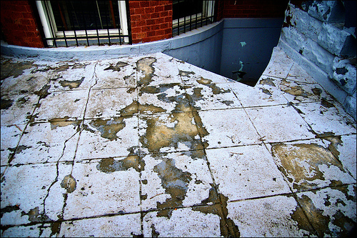
Indeed, many prehistoric “maps” may be the result of cartocacoethes – a mania, uncontrollable urge, compulsion or itch to see maps everywhere. Map simulacra like chipped paint:  a stone China:
  a mud puddle Australia:
  and “geographic tongue:”
  – a medical condition that “looks like a map.”
See also the many prehistoric squiggles (below left) illustrated in Catherine Delano Smith’s “Cartography in the Prehistoric Period in the Old World” in Brian Harley and David Woodward’s The History of Cartography, Volume One (Chicago, 1987, pp. 54-101).
 Part of me really wants these marks chipped in stone to be maps. But there does not seem to be much, if any, evidence that they are.
Why do we want mapping to stretch back into prehistory? If maps didn’t exist in prehistory, and were scarce prior to 1500, does that somehow undermine the importance of contemporary maps and mapping? What drives this cartocacoethes?
The Çatalhöyük “map” provides a great case study of the perils of prehistoric map hunting.

The Çatalhöyük map was first brought to attention in a 1964 article entitled “Excavations at Çatal Hüyük, 1963, Third Preliminary Report” by James Mellaart (Anatolian Studies 14 (1964, pp. 39-119).
A map of the excavations (right) shows the area allegedly represented on the “map.”
Mellaart’s 1967 book Çatal Hüyük: A Neolithic Town in Anatolia claimed that the Neolithic Anatolians at Çatalhöyük created the World’s first map, and fame for the map followed.
“The oldest town plan in existence” says Jeremy Harwood in To the Ends of the Earth: 100 Maps that Changed the World. “The oldest authenticated map in the world” says J.B. Harley in the UNESCO Courier. Of maps, it is, says Catherine Delano Smith in Imago Mundi, “the oldest known.” “The Catal Huyuk map … is perhaps 2000 years older than the oldest known writing system and 4000 or more years older than the oldest known alphabetical writing system…” says James Blaut in Transactions of the Institute of British Geographers. Heck, I even towed the party line in my introductory maps course lecture on the history of mapping.
Whoa, folks.
Archaeologist Stephanie Meece recently published an article in Anatolian Studies questioning the Çatalhöyük map’s status as a map. The original “map” wall painting is shown below, in a photo from Mellaart’s 1964 article. Most people have only seen the redrawing of the “map” with “volcano” (above) – not the original image.

In her article “A Bird’s Eye View – Of A Leopard’s Spots: The Çatalhöyük ‘Map’ and the Development of Cartographic Representation in Prehistory” (Anatolian Studies 56, 2006, pp. 1-16; full text here) Meece interrogates the claim that the particular wall painting found at Çatalhöyük is a map with erupting volcano in the background. Meece writes (in an email exchange):
…one of the take-home messages of the article was to go beyond the tendency to identify the images in isolation, based on a personal recognition of similarity. I wanted to emphasise the need to understand the paintings in their contexts, as part of a generations-old, well developed cultural tradition; taking one image out of its context and pointing out its superficial resemblance to something else is a bane of archaeologists, and leads to von Daniken and his spaceships.
The “volcano” in the wall painting (below top; redrawing, bottom left) was originally interpreted by Mellaart as a leopard-skin costume, similar to other leopard skin images found at Çatalhöyük (bottom right). Meece writes:
In several later paintings, notably the large so-called hunting scenes, human figures are depicted wearing stiff ‘skirts’ and head coverings that are painted with simple dots. The skirts are conventionally depicted as two wide triangles connected at their base, with two sharp points. They are twice as long as they are wide, and are filled in with dark-coloured dots, similar to the appearance of a stretched, prepared leopard skin.


The lower part of the wall painting, the “map,” does resemble the general layout of houses at Çatalhöyük, with storerooms surrounding a central room. Nevertheless, claims Meece,
These geometric designs below the leopard skin are better understood as part of the very common (though their abundance is under-represented in the published discussions of the paintings at the site) tradition of painted panels, placed along the lower registers of house walls. The ‘map’ pattern is entirely consistent with the standard range of motifs used in other buildings: a cell-like structure, repeated in horizontal lines, often with borders or frames enclosing each cell.


Meece examines an impressive array of evidence surrounding the painting and concludes
… looking closely at the wall painting, and situating it within the corpus of art objects at Çatalhöyük, it is clear that the original interpretation is much more likely to be the correct one. The painting is unlikely to be a map of Çatalhöyük, but rather depicts a leopard skin in the upper register, and the lower section is one of the very typical geometric patterns commonly found at the site.
Oh well.
In a forthcoming article entitled “Maps” Denis Wood and I argue
… if prehistoric humans did make maps – which is doubtful – they were neither made often nor in very many places; they likely served broadly pictorial, religious, ritual, symbolic, and/or magical functions; and their production was discontinuous with the practice of mapmaking encountered in historic populations.

Now this is great. Finally I have a straight answer to one of my longest-standing doubts. And I must admit that it is the answer I actually expected.
Thanks for your informative, accurate, interesting and well written posts, articles and books. Always a great read.
Speaking of making maps…Just came across something very cool. Was browsing The New York Public Library website and noticed it has a new video online that gives a behind-the-scenes snapshot of some of its map collection…which is the largest public library map collection in the world. Wanted to pass along the link: http://www.nypl.org/news/treasures/. Interesting video…check it out.
[…] E se o mapa mais antigo que se conhece não for um mapa? […]
[…] with me for quite some time: cartocacoethes – the compulsion to see maps everywhere. More on that here on the excellent blog Making Maps. Turns out that the famous Çatalhöyük map, dating from around […]
[…] UK, Africa and Australia? Further elaboration here. […]
IF…man was making maps that far back, most likely they would be carved or painted onto material that was easily portable (animal skins, bones or horns, wood, clay tablets), and have long since turned to dust.
[…] John Krygier uses the term to describe a putative map of Çatalhöyük dating from 6200 BC, citing a recent study that casts […]
[…] o excelente Making Maps explica, em inglês, em Cartocacoethes: Why the World’s Oldest Map Isn’t a Map, o mapa é na verdade apenas uma série de padrões geométricos abstratos, erroneamente […]
[…] and at other Anatolian Neolithic sites, as are chequered patterns of this type. John Krygier discusses Çatalhöyük and Meece’s article, with many illustrations and references, at the Making Maps blog. He suggests the history of the […]
[…] and at other Anatolian Neolithic sites, as are chequered patterns of this type. John Krygier discusses Çatalhöyük and Meece’s article, with many illustrations and references, at the Making Maps blog. He suggests the history of the […]
Hi !!! :)
My name is Piter Kokoniz. Just want to tell, that your posts are really interesting
And want to ask you: what was the reasson for you to start this blog?
Sorry for my bad english:)
Thank you:)
Your Piter Kokoniz, from Latvia
Hi Piter
The blog is meant to be a supplement to the book (“Making Maps” – thus some of the categories on the blog are tied to specific book chapters) and is a way for me to share interesting map information I have accumulated over the years. I try to post material that is not on the web, or difficult to find, or is just interesting to me.
Brilliant article:) I’m a keen amateur follower of all the excavations in Turkey, loved it, thanks.
NM
[…] Why the World’s Oldest Map Isn’t a Map […]
[…] uncontrollable urge to see maps in everyday, non-cartography-related objects.” The term was originally detailed on John Krygier’s Making Maps blog. Strange Maps has two posts representing a collection of […]
Catalhoyuk is such an important site in archeological terms, from neolithic mounds to the evidence for early domesticated farming and sheep herding. Not only this but the artistic evidence too like this “map” – amazing.
to john kryeger
I find your explanation too much emotive and a little bit phanatical about asserting that the rest of the painting in the wall known as Catalhoyuc map is not a map, giving more value to the “vision ” of the people that everywhere see “abstract art patterns” than to the “vision” of people that everywhere see maps I think that there is not any reazonable argument to do what you do .If you look into the concept of posible conception (lucien goldman) you will find that in communication processes what you get from a message like the “catalhoyuk map” (ie abstract art or a map or a tiger or stars ) is influenced by your personal experience so please keep looking at the map as your posible conception allows you and give other people the same right. respectfully Carlos Salman Gonzalez ( from mexico)
I agree. Methinks they doth protest too much. Keeping the image *in* context, the similarities to actual structures found is worth more than a blanket denial that the image isn’t representational.
[…] en Turquía, data del año 6.200 AC y es anterior al nacimiento de la escritura. Ha sido objeto de muchas polémicas (¿es una ilustración? ¿es un mapa?) y es considerado por muchos el mapa más antiguo. La pintura […]
[…] en Turquía, data del año 6.200 AC y es anterior al nacimiento de la escritura. Ha sido objeto de muchas polémicas (¿es una ilustración? ¿es un mapa?) y es considerado por muchos el mapa más antiguo. La pintura […]
[…] uncontrollable urge to see maps in everyday, non-cartography-related objects.” The term was originally detailed on John Krygier’s Making Maps blog. Strange Maps has two posts representing a collection of […]
Early people must have had a cognitive map of their environment in order to navigate, locate and share what they knew/ did not know about it. From this starting point surely we need to ask some quality questions about our notions of the possibility/ probability of map making?
It is certainly important to ask questions about the possibility of map-making in prehistory. But such inquiries must take into account the lack of evidence. The number of maps from prehistory is just about none, and they are rare for much of recorded human history. Some of us, particularly geographers and map fans, are so used to maps as a part of our day to day lives that we just can’t imagine a world without them. We then impose this map culture on the past, despite the lack of evidence, and start to see maps where there are none. That is not good. Think instead of people who have no need for maps. My wife would be completely happy if she never had to look at a map. If she needs directions, she uses the list of directions generated by Google Maps (not the map itself). She listens to her GPS (but doesn’t look at the map). This is a common human trait: being able to navigate and understand the world without maps. With a sophisticated cognitive “map” of the environment and no cultural traits that demanded accurate delineation of geographic space (such as property ownership) pre-historical people would be able to function just fine in a world without maps.
[…] in 2008 the word cartocacoethes was first used on this blog to describe “a mania, uncontrollable urge, compulsion or itch to […]
[…] Another ancient picture that resembles a map was created in the late 7th millennium BCE in Çatalhöyük, Anatolia, modern Turkey. This wall painting may represent a plan of this Neolithic village; however, recent scholarship has questioned the identification of this painting as a map. […]
[…] was a term first coined by from the Making Maps blog to describe “a mania, uncontrollable urge, compulsion or itch to see maps everywhere.” The cartographic equivalent to seeing Jesus in burnt toast, the terminology is a concatenation […]
[…] cartophilia takes many forms, but one of the strangest (and hardest to pronounce) is cartocacoethes (kart-oh-kak-oh-EE-theez), the tendency to see random patterns as maps. This mouthful of a word […]
[…] neolithic town in Anatolia I MAP I The power of maps and […]
[…] из самых странных и причудливых является картомания (cartocacoethes, тот редкий случай, когда русский термин короче и […]
[…] also the creator of one of my favorite cartographic terms, cartocacoethes, which he defined as “a mania, uncontrollable urge, compulsion or itch to see maps everywhere.” Hi co-author, Dennis Wood, is a former professor of design at North Carolina State […]
[…] del sole. C’è addirittura chi vuol far risalire le prime mappe al 7500 a.C., ma su tali teorie ci sono forti controversie. La mappa in assoluto più famosa in questo campo è quella di Charles Joseph Minard, ingegnere […]
[…] was a term first coined by John Krygier from the Making Maps blog to describe “a mania, uncontrollable urge, compulsion or itch to see maps everywhere.”The cartographic equivalent to seeing Jesus in burnt toast, the terminology is a […]
I would make these comments.
1 The antikythera mechanism would not have a predictable invention of Greeks over 2,000 years ago but there it is. Reconstructions work perfectly well. Similarly, the cuneiform musical notation to the Hymn to Nikea would seem unlikely but again there it is and it is playable.
2 Humans as a species try to make patterns from everything they see, constellations in the sky being an obvious example. It is true that the ‘map’ may not be what it seems, my understanding was that, if a map it, represented a town with streets, something not present at Catalhoyuk. So it may or may not be a map. We can not look into the minds of advanced prehistoric peoples, but actual discoveries tend to show more advancement than we had previously considered. The presence of the town itself, so far back in time could not have been predicted just a few years ago.
3 Finally, after a short break Pluto has now had its planetary status restored. We make our own decisions through our own prisms.
[…] map-related variants. One is called cartocacoethes: seeing maps where there aren’t any. See here for more. The other is cartozoology, and it describes Mr Hoyte’s hobby: the discovery and […]