Feeds:
Posts
Comments

Posts Tagged ‘Maps – History’

Fujimi_jusanshu_yochi_zenzu_c2 Fujimi_jusanshu_yochi_zenzu_c1

Fujimi_jusanshu_yochi_zenzu_c_legFujimi_jusanshu_yochi_zenzu_c0

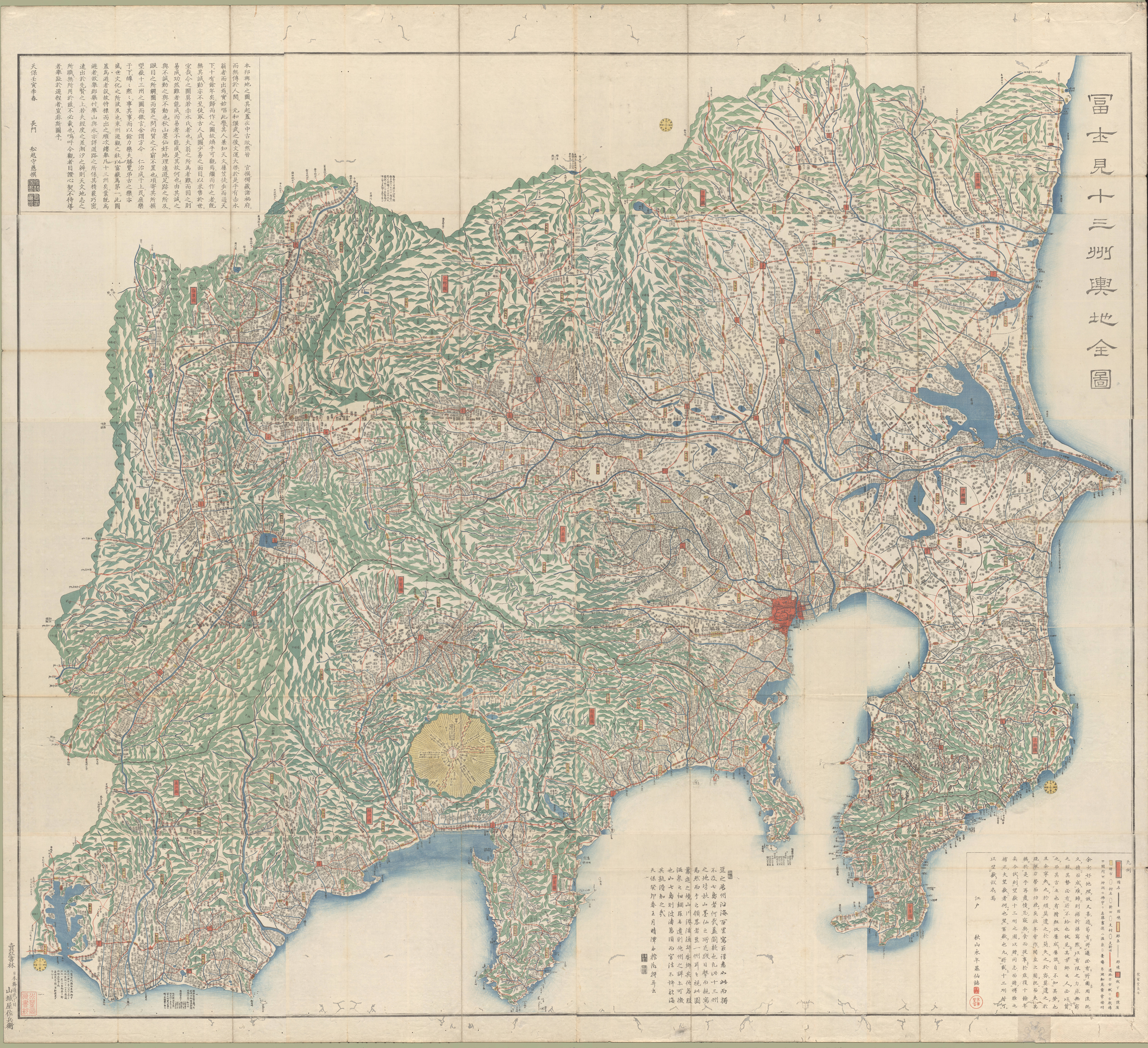
Fujimi jūsanshū yochi zenzu
(Map of the thirteen provinces from which Mt. Fuji is visible)
1843  |  Edo : Yamashiroya Sahei
Source

••••••••••

Kaiho_Kai_no_Kuni_ezu_c2 Kaiho_Kai_no_Kuni_ezu_c1

Kaiho_Kai_no_Kuni_ezu_c_legKaiho_Kai_no_Kuni_ezu_c0

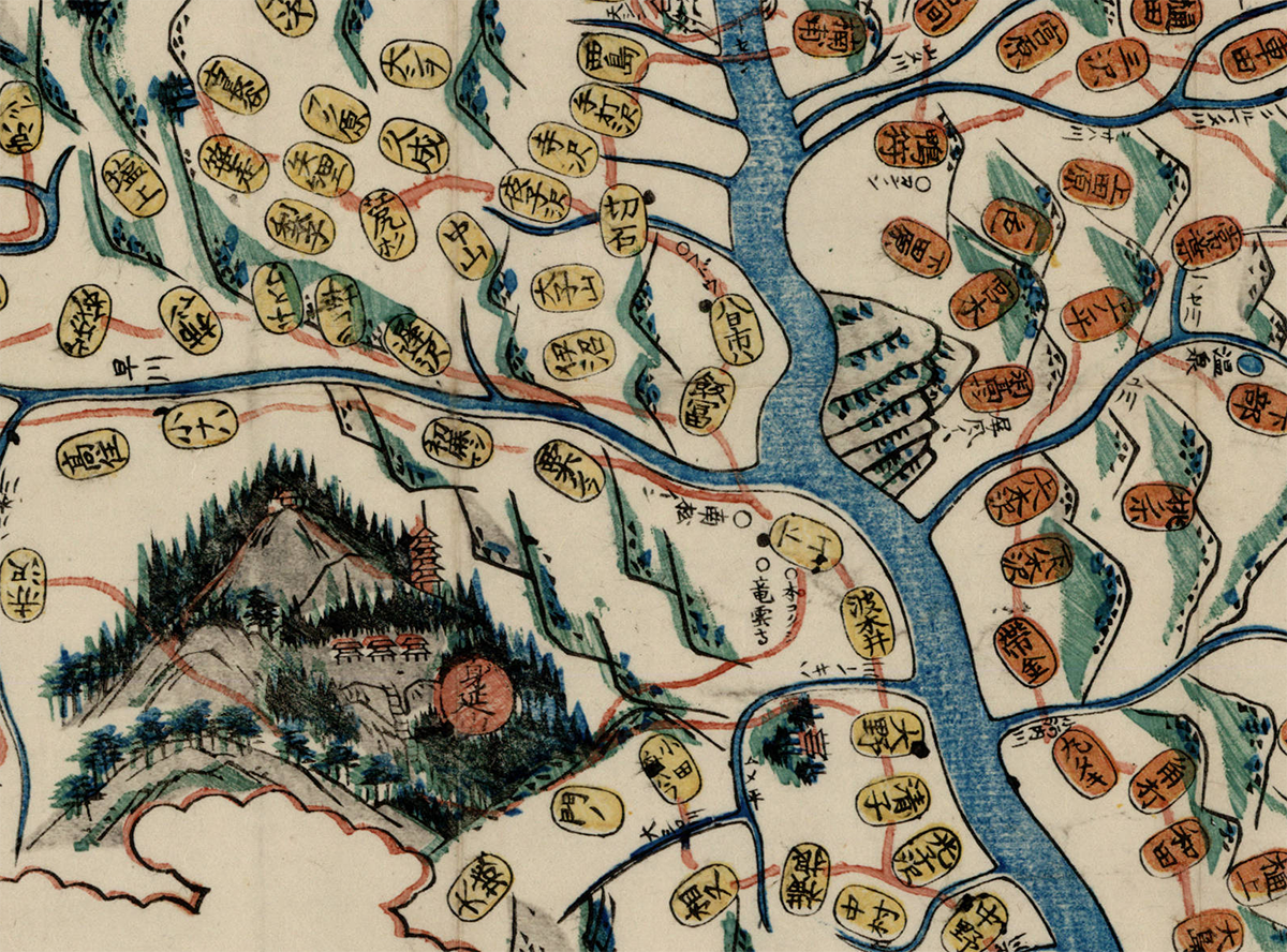
Kaihō Kai no Kuni ezu
(Pocket map of Kai Province)
1842  |  Kōfu, Kai Province : Murataya Kōtarō
Source

••••••••••

saka_yori_Tokai_ni_itaru_kairo_no_zu_c2 saka_yori_Tokai_ni_itaru_kairo_no_zu_c1 saka_yori_Tokai_ni_itaru_kairo_no_zu_c0

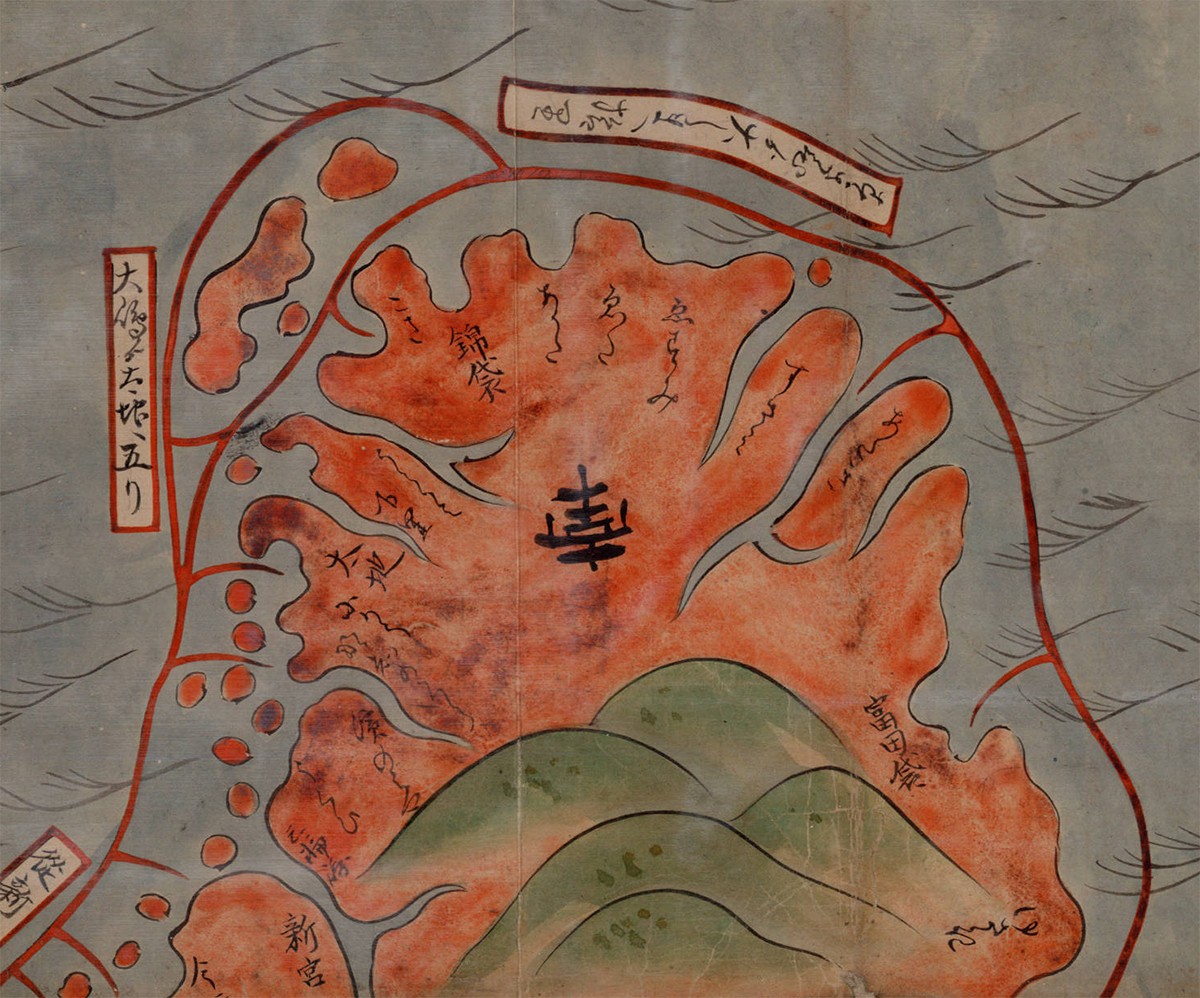
 Ōsaka yori Tōkai ni itaru kairo no zu
(Tōkaidō and the sea route from Ōsaka to Edo)
1855  |  Manuscript
Source

••••••••••

Shiga_kenka_Shigagun_Fujiomura_chinai_aza_hira_Kaigaya_Maegaki_jissokuzu_c2 Shiga_kenka_Shigagun_Fujiomura_chinai_aza_hira_Kaigaya_Maegaki_jissokuzu_c1

Shiga_kenka_Shigagun_Fujiomura_chinai_aza_hira_Kaigaya_Maegaki_jissokuzu_c_legShiga_kenka_Shigagun_Fujiomura_chinai_aza_hira_Kaigaya_Maegaki_jissokuzu_c0

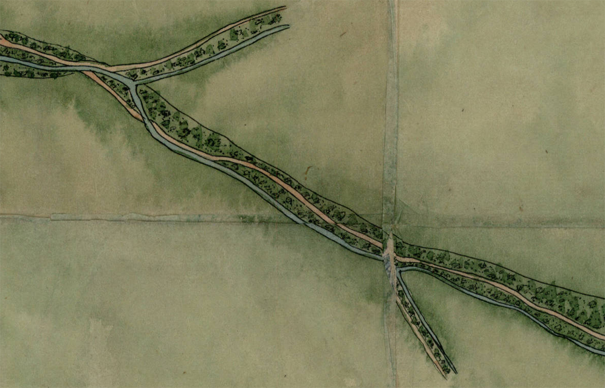
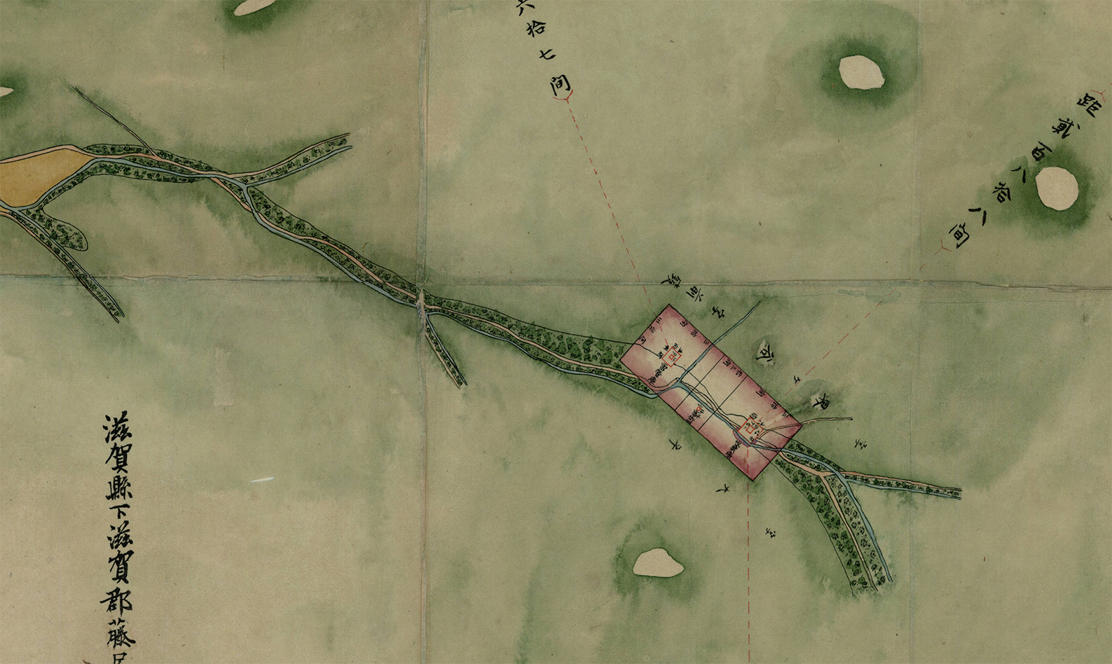
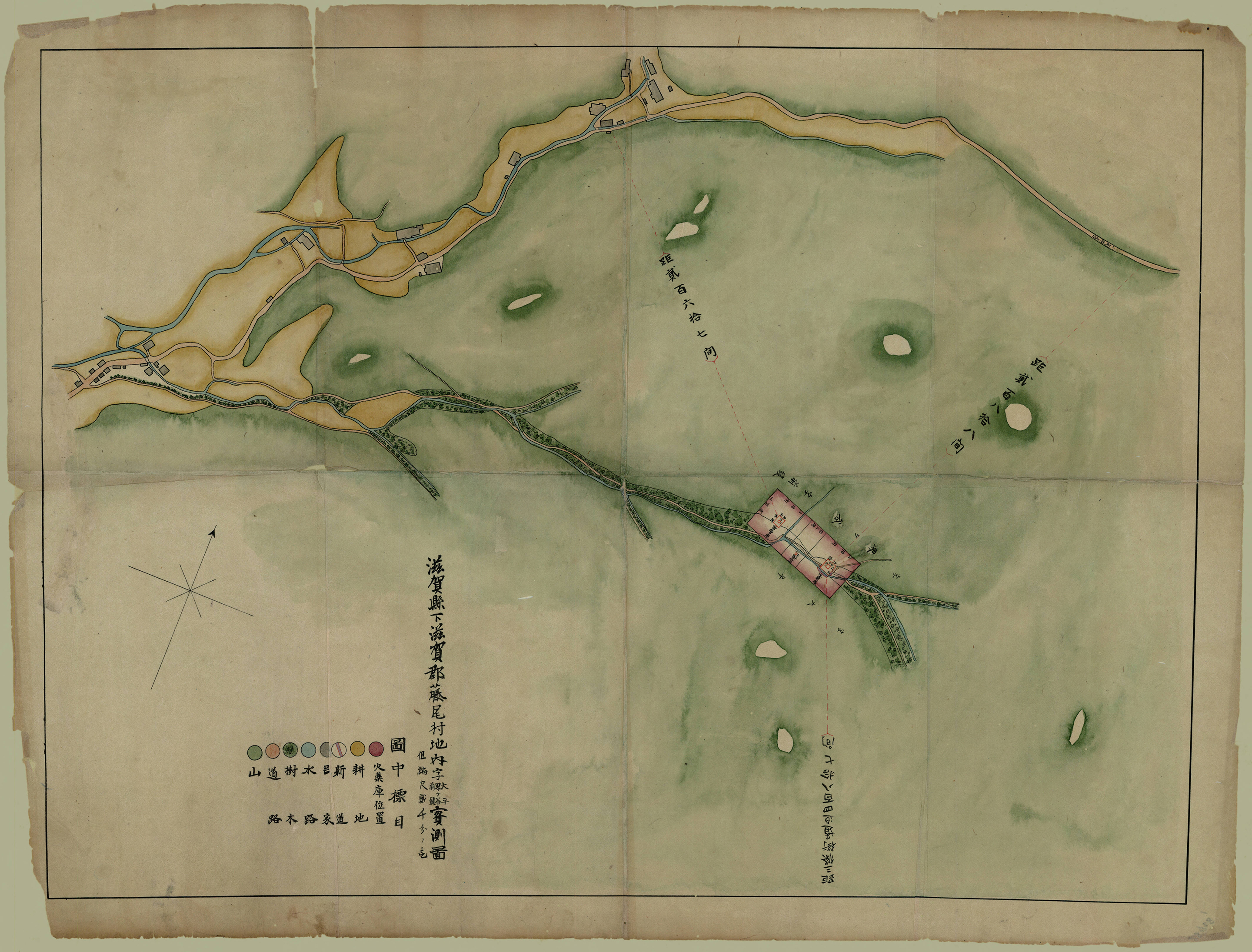
Shiga kenka Shiga-gun Fujio-mura chinai aza Ōhira Kaigaya Maegaki jissokuzu
(Measured map of Ōhira Kaigaya Maegaki, in Fujio Village, Shiga County, Shiga Prefecture – Gunpowder Safety Map)
1870  |  Manuscript
Source

••••••••••

University of British Columbia
Collection: Japanese Maps of the Tokugawa Era
Source & Description

Read Full Post »

The World Is Round! (1935)

••••••••••

Air Mapping (1935)

••••••••••

Moon Mapping (1953)

••••••••••

Map to the Coronation (1937)

••••••••••

Mainly Maps (1938)

••••••••••

Mapping It Out! (1940)

••••••••••

Map Depot In Desert (1943)

••••••••••

Map Making By Women’s Voluntary Service – Quite So! (1943)

••••••••••

New Maps for New Worlds (1945)

••••••••••

Mobile Map Truck (Step On It!) (1944)

••••••••••

Plastic Maps (1947)

••••••••••

Map Making (1952)

••••••••••

Interpol See Scotland Yard (Pre-Computer GIS) (1958)

••••••••••

Map Making (1961)

••••••••••

School Playground Map (1961)

••••••••••

Map Survey (1965)

••••••••••

Aerial Photography Aids Map Makers – Hungary (1965)

Read Full Post »

Schulten_Chinatown

Detail from a rare 1885 map showing vice in San Francisco’s Chinatown. Vice includes gambling (dark orange), Chinese prostitution (green), opium houses (yellow), Joss Houses (red) and White prostitution (blue). The map, from the Rumsey Map Collection, is an early example of detailed urban social mapping, in this case motivated by strong anti-Chinese sentiment. Click on the map (above) for more details from Historian Susan Schulten’s blog Mapping the Nation.

Schulten’s blog and website for her terrific book Mapping the Nation: History and Cartography in Nineteenth-Century America contain a wealth of maps and graphics. The book itself looks at the pivotal 19th century – when mapping expanded to include a diversity of human, social, cultural, political and environmental phenomena.

Selected details of maps from the blog are below: click on the title or image to see the entire map.

••••••••••

schulten_ch1-1

Emma Willard, “Introductory” Map of American History (1828)

“This map opened one of the first historical atlases of America, created by the noted educator Emma Willard. Note that she marked not just the location of tribes, but their migration over time.”

••••••••••

Schulten_ch1-2

Emma Willard, “First” Map of American History (1828)

“Willard’s second map in the atlas marked the earliest voyages to America, and took pains to represent change over time. Note the inclusion of failed voyages and settlements.”

••••••••••

Schulten_ch2-1

Diagram of the History of Political Parties in the United States (to 1880) (1880)

“Here is one of the many attempts to represent American history in graphic terms that flourished in the wake of the nation’s centennial, and which was updated in 1894.”

••••••••••

Schulten_ch2-2

Transportation and Rates of Travel (1932)

“Here Charles Paullin represented advances in transportation technology in geographic terms in order to depict the qualitative changes over the course of American history.”

••••••••••

Schulten_ch3-1

Course of Cholera in Boston in 1849 (1849)

“This is one of many examples of a map designed for etiological purposes, in this case to locate the source of the city’s 1849 cholera epidemic.”

••••••••••

Schulten_ch3-2

Sanitary Map of the City of New Orleans (1855)

“Barton compiled this complex map to locate the origin of the yellow fever outbreak of 1853, even noting the arrival of ships in the city port.”

••••••••••

Schulten_ch4-1

Map of the Cotton Regions of North America (1862)

“Mallet designed this complex map to guide the British as they developed cotton in India, drawing on existing geological and environmental maps from the era.”

••••••••••

Schulten_ch4-2

Map Showing the Distribution of the Slave Population of the Southern States (1861)

“One of the first American attempts to translate the census into cartographic form, and a favorite of President Lincoln during the Civil War.”

••••••••••

Schulten_ch5-1

Map of Bison Distribution Over Time (1876)

“This map depicts the shrinking bison population, highlighting the effects of expansion at the nation’s centennial. It became the model for William Temple Hornaday’s well-known map of 1887.”

••••••••••

Schulten_ch5-2

Geological Map of the United States (1872)

“This stunning map owed much to its antebellum maps of geology as well as the fine chromolithography of Julius Bien.”

••••••••••

9780226103969

Susan Schulten
Mapping the Nation: History and Cartography in Nineteenth-Century America
University of Chicago Press, 2012

Part One: Mapping the Past

Chapter 1: The Graphic Foundations of American History
Chapter 2: Capturing the Past through Maps

Part Two: Mapping the Present

Chapter 3: Disease, Expansion, and the Rise of Environmental Mapping
Chapter 4: Slavery and the Origin of Statistical Cartography
Chapter 5: The Cartographic Consolidation of America

Read Full Post »

spanish_health_areas_1936

Catalonian Health Administration Areas (1936-39)

•••••

spain_foreign_interests_1937

Foreign interests allied against the Spanish Republic (1937)

•••••

spain_aragon_front_1936

Aragon Front of the war: Republican gains shown as broken barbed wire, prisoners taken shown as silhouettes of men marching under guard, and captured armaments shown as images of specific weapons with numbers captured (1936).

•••••

german_campaigns_1914-8

The Way to Peace! Nine maps of German campaigns from August 1914 to spring 1918.

•••••

german_impact_british_shipping_1917

The Impact of Our Submarines: Reduction in shipping, south-east Britain, due to German Submarines (1917)

•••••

Imperial War Museum @ VADS

Spanish Civil War Poster Collection

Posters of Conflict Collection

•••••

Thanks to A London Salmagundi for original link

Read Full Post »

Scouts, snipers, poison gas, gas masks, trench warfare, rifle ranges, gun positions… Maps and war ca 1917…

1917_Map_reading_and_intelligence_training_09

And a terrific type at that.

•••••••

Map Reading and the Training of the Intelligence Section, i.e., Scouts, Snipers and Observers are a group of subjects which every officer should personally take interest in.

Not only because they are, as subjects, most interesting, but because they are of the most vital importance when in actual warfare.

To be unable to take a map of a strange sector of country, and thoroughly understand what every line and sign means, is to be helpless in the face of the enemy.

Consequently, I would advise every officer, N.C.O and man to improve his knowledge on map reading and its component parts, as active service in war will call on them every day for a thorough understanding of this subject.

LIEUT. COL. R. B. HAMILTON
Late O.C. Queen’s Own Rifles, 1917

•••••••

1917_Map_reading_and_intelligence_training_01

Orienteering with maps.

•••••••

1917_Map_reading_and_intelligence_training_02

Orienteering with maps.

•••••••

1917_Map_reading_and_intelligence_training_03

In Plate No. 10-A, we have a sample page of a field book after the traverse has been made and all the desired notes are completed ready to plot on arriving at headquarters or camp.

••••••• 1917_Map_reading_and_intelligence_training_04

Trench raid mapping.

•••••••

1917_Map_reading_and_intelligence_training_05

Trench map showing snipers and observation posts.

•••••••

1917_Map_reading_and_intelligence_training_06

Indirect firing at the longer ranges requires a proper fixed rifle stand, something on the lines of the stand shown in plate No. 25.

•••••••

1917_Map_reading_and_intelligence_training_07

Gun position.

•••••••

1917_Map_reading_and_intelligence_training_08

Map showing gun ranges and compass bearings.

•••••••

C. D. A. Barber

Map Reading and Intelligence Training.

Cleveland, Edward McKay, 1917

Book available at Google Books

Read Full Post »


Map symbols for river and river related features on Latvian topographic maps of the 1920s and earlier. From the book

Apzimejumi Merniecibas un Kulturtechniskiem Planiem

(Legends from Surveying and Cultural-Technical Plans)

Ministry of Agriculture

Riga, Latvia, 1928.

[4.4mb pdf of entire booklet here]

Original plate with translation to English below:


p = parkland

n = marshland

v = heath

zp = fens

s = sand / desert

sp = moss bog

grb = gravel pit

ak = stone pit

kp = peat bog

akl = quarry

sb = sand pit

mb = clay pit

Read Full Post »

Map symbols for bridges and river related features on Latvian topographic maps of the 1920s and earlier. From the book

Apzimejumi Merniecibas un Kulturtechniskiem Planiem

(Legends from Surveying and Cultural-Technical Plans)

Ministry of Agriculture

Riga, Latvia, 1928.

Original plate with translation to English below:

Bridges:

Iron

Stone

Wood

Pontoon

Raft

Toll Bridges:

Iron

Stone

Wood

Floating Bridge

Locks:

Stone

Wood

Anchored Raft

Boat Raft

Oared Raft

Roped raft

Boundary in the middle of the river

Boundary at the edge of the drainage ditch

Read Full Post »

Map symbols for roads and road related features on Latvian topographic maps of the 1920s and earlier. From the book

Apzimejumi Merniecibas un Kulturtechniskiem Planiem

(Legends from Surveying and Cultural-Technical Plans)

Ministry of Agriculture

Riga, Latvia, 1928.

Original plate with translation to English below:

Public Roads:

1) a, b – carriageway edge

2) carriageway:
c – stone or macadamized, d – wood, e – gravel, f – unbuilt

3) g – culverts

4) h – stone bridge

5) i – rail bridge

6) k – road shoulder

7) l – ditches

8) m – greenery / vegetation

 a – entrenchment

 b – embankment

 c – slope to one side

 d – marsh dams

 e – ditches

Winter road

Trail

Private roads

1) a, b – outer edge

2) carrageway:
c – unbuilt, d – stone or macadamized, e – wood, f – gravel;

3) g – culverts

4) h – wooden bridge

5) i – ditch

•••••••••••••••••••••••••••••••••••••

A scarce booklet of map symbols that appears in only one library (Berlin State Library) according to the global library catalog WorldCat. I will post more symbols from this booklet in the near future, as well as a PDF of the entire booklet.

Read Full Post »

The Survey of Egypt, 1910, 1:1,000,000, Sheet 5 (detail 1, close-up)

•••

Found while cleaning out an old map cabinet: oceans of just about nothing, punctuated by signs of a minimal landscape. Soiled, creased, tears, dusty. Thumb-print and fading pencil marks, from someone who stared at this map a long time ago.

Details from a topographic map of Egypt in 6 sheets, published by The Survey of Egypt in 1910, scale 1:1,000,000.

Click on any map for a larger version of the scan.

•••

The Survey of Egypt, 1910, 1:1,000,000, Sheet 5 (detail 1)

•••

The Survey of Egypt, 1910, 1:1,000,000, Sheet 1 (detail 1)

•••

The Survey of Egypt, 1910, 1:1,000,000, Sheet 1 (detail 2)

•••

Note the type leaking over the map border (Mediterranean, Lake Borollos, Gharbia)

The Survey of Egypt, 1910, 1:1,000,000, Sheet 1 (detail 3 – close-up)

•••

Note the type leaking over the map border (Mediterranean, Lake Borollos, Gharbia)

The Survey of Egypt, 1910, 1:1,000,000, Sheet 1 (detail 3)

•••

The Survey of Egypt, 1910, 1:1,000,000, Sheet 3 (detail 1 – close-up)

•••

The Survey of Egypt, 1910, 1:1,000,000, Sheet 3 (detail 1)

•••

The Survey of Egypt, 1910, 1:1,000,000, Sheet 5 (detail 2)

•••

The Survey of Egypt, 1910, 1:1,000,000, Sheet 6 (detail 1)

Read Full Post »