Erwin Raisz is among the most creative cartographers of the 20th century, known in particular for his maps of landforms.
In 1931 Raisz outlined and illustrated the methods behind his landform maps, in an article in the Geographical Review (Vol. 21, No. 2, April 1931). Excerpts from the text and graphics in the article are included below.
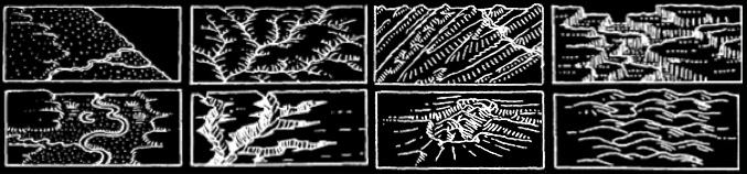
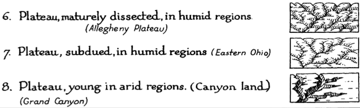
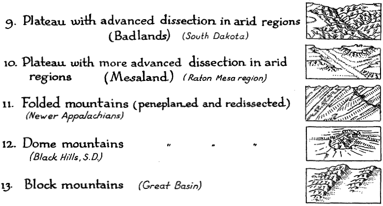
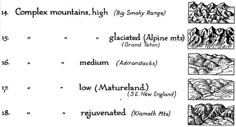
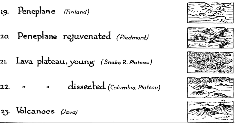
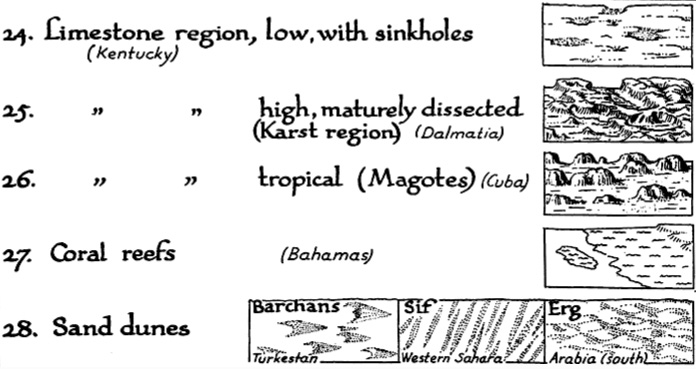
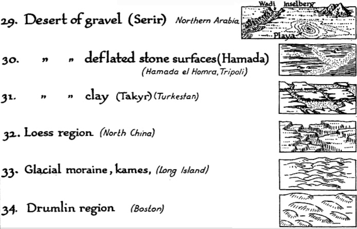
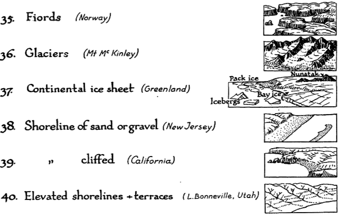
Raisz’s approach is to create complex pictorial map symbols for specific landform types. Each specific application, of course, would have to modify the symbols to fit the configuration of particular landforms.
One of the limitations of Raisz’s work is that it is so personal and idiosyncratic that it virtually defies automation or application in the realm of computer mapping. Thus digital cartography has, in some cases, limited the kind of maps we can produce.
Raisz writes:
There is one problem in cartography which has not yet been solved: the depiction of the scenery of large areas on small-scale maps.


Most of our school maps show contour lines with or without color tints. Excellent as this method is on detailed topographic sheets … it fails when it has to be generalized for a small-scale map of a large area. Nor does the other common method, hachuring, serve better.
For the study of settlement, land utilization, or any other aspect of man’s occupation of the earth it is more important to have information about the ruggedness, trend, and character of mountains, ridges, plains, plateaus, canyons, and so on-in a word, the physiography of the region.
Our purpose here is to describe and define more closely a method already, in use, what we may call the physiographic method of showing scenery. This method is an outgrowth of the block diagram. [T]he method was fully developed by William Morris Davis. Professor Davis has used block diagrams more to illustrate physiographic principles than to represent actual scenery.
Professor A. K. Lobeck’s Physiographic Diagram of the United States and the one of Europe do away entirely with the block form, and the physiographic symbols are systematically applied to the vertical map. His book Block Diagrams is the most extended treatise on the subject.
It is probable that the mathematically-minded cartographer will abhor this method. It goes back to the primitive conceptions of the early maps, showing mountains obliquely on a map where everything should be seen vertically. We cannot measure off elevation or the angle of slope. Nevertheless, this method is based on as firm a scientific principle as a contour or hachure map: the underlying science is not mathematics but physiography.
If we regard the physiographic map as a systematic application of a set of symbols instead of a bird’s-eye view of a region, we do not violate cartographic principles even though the symbols are derived from oblique views instead of vertical views. It may be observed that our present swamp symbols are derived from a side view of water plants.
••••••
Landform map symbols include: plains (sand & gravel, semiarid, grassland, savannah, forest, needle forest, forest swamp, swamp, tidal marsh, cultivated land), coastal plain, flood plain, alluvial fans, conoplain, cuesta land, plateau (subdued, young, dissected), folded mountains, dome mountains, block mountains, complex mountains (high, glaciated, medium, low, rejuvenated), peneplane, lava plateau (young, dissected), volcanoes, limestone region (with sinkholes, dissected, karst, tropical, mogotes), coral reefs, sand dunes, desert of gravel (serir), deflated stone surfaces (hamada), clay (takyr), loess region, glacial moraine, kames, drumlin region, fjords, glaciers, shoreline (sand, gravel, cliffed), and elevated shorelines & terraces.

[…] from John Krygier’s April 3, 2008 post on his DIY blog. Erwin Raisz is among the most creative cartographers of the 20th century, known […]
Wow! This is an extensive and informative list that will definetly inspire my artwork.
Thanks for taking the time to compile this blog!
I’ve got to say I am thrilled that I found your blog and this post in particular. My own particular interest is in role-playing and wargaming, but this is a wonderful addition to any map-enthusiasts repertoire.
Beautiful illustrations!
Thank you for articulating Raisz technological novelty. That answered to some questions that arose while admiring some of his work.
Wur non-profit produces great numbers of mediocre maps (we do other things well) even thought maps should be our showcase. Is there an organization of cartographers we might approach to find Raisz inspired interns?
Tom Magnuson
A significant accumulation of cartographic craftspersons can be found at cartotalk.com
The North American Cartographic Information Society (NACIS) has as members many great design cartographers. http://www.nacis.org
john k.
Mapdiva is pleased to make available a free symbol collection for Ortelius software today, including several Raisz-inspired symbols. Though Raisz’ style defies automation, having a few hill and mountain symbols is always a nice addition for pictorial maps. Additional hill and mountain symbols are inspired by Abraham Ortelius and calligrapher Heather Child. If you’d like to share , here is the link for more info and download: http://www.mapdiva.com/2010/08/ortelius-free-mountains-map-symbols/
Jill Saligoe-Simmel
Tom and John,
The Raisz family reprinted many of Erwin Raisz’s maps and the maps are now available through http://www.raiszmaps.com.
And if you’re ever in the Boston vicinity make sure you drop in to the Harvard Map Collection to see some fabulous manuscript items in the Raisz collection.
Reblogged this on Schedim's Blog and commented:
Fantastic cartographic source of inspiration!
I would Love to try this
Reblogged this on Kathy Roydon and commented:
This was a fascinating and useful post for anyone struggling to create their own maps and making them legible! I learned more from this post than in several other search attempts.
[…] also, at this blog, Raisz’s History of American Cartography Timelines, Map Symbols: Landforms & Terrain, and Raisz’s currently available landform maps […]
fabulous resource! Thanks!
Garbage did not help me at all
Anyone have a visual specifically for “Rough Terrain”, specifically for wargame maps?
A bit of background on the Erwin Raisz landform symbols: Raisz was a geomorphologist, those are people who study landforms. Thus the symbols he developed follow categories of landforms as defined by geomorphology. There are many other kinds of landforms – like “rough terrain” which could be created, but Raisz did not have them as that is not really a geomorphological category. Google “fantasy maps” or see if someone at https://www.cartographersguild.com/forum.php has created some examples.